more stats
1.5 miles
Distance
6 ft
Climb
-727 ft
Descent
00:09:52
Avg time
-721 ft
Altitude change
7,607 ft
Altitude min
8,328 ft
Altitude max
8,328 ft
Altitude start
7,608 ft
Altitude end
-9.2%
Grade
-35.2%
Grade max
5.2%
Grade min
177 ft
Distance climb
1 mile
Distance down
558 ft
Distance flat
00:09:52
Avg time

Holy Molé Details

  • Activities
    • Mountain Bike
    • E-Bike
    • Adaptive Bike
  • Riding Area
    Glorieta Adventure Camps
    Santa Fe, New Mexico
  • Difficulty Rating
  • Voted Difficulty
    Blue (1 vote)
  • Local Popularity
    95 in Mountain Biking [+]
    • 95 in E-Biking
  • Global Ranking
    #22118 in Mountain Biking [+]
    • #16087 in E-Biking
  • Trail Type
    Singletrack
  • Bike Type
    DH, AM, XC, DJ, Adaptive MTB
  • Climb Difficulty
    Blue
  • Physical Rating
    Moderate
  • Dogs Allowed
    Yes
  • eBike Allowed
    Yes up to Class 3
  • TTFs on Trail
    Berm, Jump, Gap Jump, Roller Coaster
  • Year Opened
    2017
  • Land Owner
    Glorieta Adventure Camps

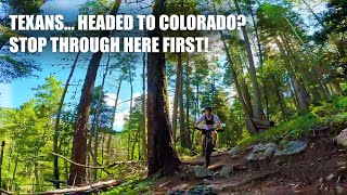
Machine built with enhancements and new sections added in the fall of 2017. Lots of A/B options with the A line having lots of jumps and drops. Berms, table tops, rollable doubles in addition to A options.

ADAPTIVE MTB INFO
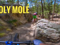
Rating: aMTB3 - Major Obstacles Exist - Precarious Rock Garden, Off Camber, Tight Berms - Support Rider Needed

Access Info

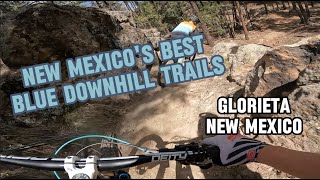
Glorieta Camps - Access via Baptist Bypass or permission through main gate.

Trail Supporters
  • Jagged Axe Designs
    Builder

  • USFS
    Land Manager
Local Trail Association
Traditionally Indigenous Territory

Recent Activity on Trail

Past Week
  • 0 rides
  •  
6 Months
  • 87 rides
  • 13 miles avg distance
All
  • 894 rides
  • Last: Jun 8, 2026
c1c2c3c4
January
February
March
April
May
June
July
August
September
October
November
December
update trails status or condition

Holy Molé Trail Reports

statusdatedescription
Jun 17, 2026 @ 10:15am (America/Denver)
3 days
reporter Closed For Construction! Holy Mole is getting reworked! This project will be ongoing for the next 4-6 weeks, we expect it to be re opened end of...
Jun 10, 2026 @ 1:59pm (America/Denver)
Jun 10, 2026
Closed for construction!
Mar 21, 2026 @ 10:50am (America/Ciudad_Juarez)
Mar 21, 2026
Dusty
Mar 4, 2026 @ 9:51am (America/Denver)
Mar 4, 2026
reporter
Feb 27, 2026 @ 6:07pm (America/Denver)
Feb 27, 2026
Heads up 2 large trees are down. One you can see with plenty of notice the other one sneaks up on you on a steep descent. Otherwise running great.
more »
Status:
on Jun 17, 2026
Avg: 4.58 (21 votes)
Your vote: 0

view (3,926)
close
3D
Trail Conditions
  • Unknown
  • Snow Groomed
  • Snow Packed
  • Snow Covered
  • Snow Cover Partial
  • Freeze/thaw Cycle
  • Icy
  • Prevalent Mud
  • Wet
  • Variable
  • Ideal
  • Dry
  • Very Dry
Trail Flow (Ridden Direction)
Trailforks scans users ridelogs to determine the most popular direction each trail is ridden. A good flowing trail network will have most trails flowing in a single direction according to their intension.
The colour categories are based on what percentage of riders are riding a trail in its intended direction.
  • > 96%
  • > 90%
  • > 80%
  • > 70%
  • > 50%
  • < 50%
  • bi-directional trail
  • no data
Trail Last Ridden
Trailforks scans ridelogs to determine the last time a trail was ridden.
  • < 2 days
  • < 1 week
  • < 2 weeks
  • < 1 month
  • < 6 months
  • > 6 months
Trail Ridden Direction
The intended direction a trail should be ridden.
  • Downhill Only
  • Downhill Primary
  • Both Directions
  • Uphill Primary
  • Uphill Only
  • One Direction
Contribute Details
Colors indicate trail is missing specified detail.
  • Description
  • Photos
  • Description & Photos
  • Videos
Trail Popularity ?
Trailforks scans ridelogs to determine which trails are ridden the most in the last 9 months. Trails are compared with nearby trails in the same city region with a possible 25 colour shades. Think of this as a heatmap, more rides = more kinetic energy = warmer colors.
  • most popular
  • popular
  • less popular
  • not popular
ATV/ORV/OHV Filter
Max Vehicle Width
inches
US Cell Coverage
Legend
cell carrier legend

Radar Time
Activity Recordings
Trailforks uses anonymized public activity data. ?
Activity Recordings
Trailforks uses anonymized public activity data. ?
Personal Heatmap
Activity Types
all / none
Options
2
Date range month
Winter Trails
Warning A routing network for winter maps does not exist. Selecting trails using the winter trails layer has been disabled.
Missing Trails
Most Popular
Least Popular
Trails are colored based on popularity. The more popular a trail is, the more red. Less popular trails trend towards green.
Jump Magnitude Heatmap
Heatmap of where riders jump on trails. Zoom in to see individual jumps, click circles to view jump details.
BC Backroad Status

Service Road Atlas is a free to use, community-driven service for viewing and creating reports on the numerous back-country service roads around B.C. and Alberta.

map legend
Slope Aspect
Direction the slope faces
Flat N NE E SE S SW W NW
Trails Deemphasized
Trails are shown in grey.
disable
Only show trails with no bike usage.
Enable
Suggested Layers
Based on selected activity type

    Save the current map location and zoom level as your default home location whenever this page is loaded.

    Save
        Directions to holy-mole trailhead (35.607770, -105.757140)

        Photos

        19 more »
        102 |
        Dec 3, 2025 @ 3:36pm
        Dec 3, 2025
        97 |
        Dec 3, 2025 @ 3:36pm
        Dec 3, 2025
        526 |
        Aug 25, 2020 @ 3:19pm
        Aug 25, 2020
        503 |
        Aug 25, 2020 @ 3:20pm
        Aug 25, 2020

        Videos

        10 more »
        Colorado MTB Trip 2025 | Santa Fe, NM |...
        39:10 | 53 | Nov 25, 2025 , Santa Fe
        First time riding Holy Molé at Glorieta
        113 | Jun 9, 2025 , Santa Fe
        RIPPING NEW MEXICO'S BEST BLUE DOWNHILL TRAILS
        19:44 | 173 | May 5, 2024 , Santa Fe
        Incredible Downhills | Mountain Biking Holy...
        9:42 | 195 | Feb 22, 2024 , Santa Fe

        Routes with this trail

        4.0 13 miles 2,055 ft 7 Out & Back
        Yes the stories are true: trails at Glorieta Adventure Camps are hard! This route, though, encompasses...
        5.0 22 miles 3,874 ft 68 Loop
        One of the best rides in NM (In my opinion). Has 4 amazing downhills, 3 of which having singletrack climbs...
        6 miles 1,106 ft 5
        6 mi intermediate route through ruiz and holy mole

        6 Reviews & Comments


        We hope you've been enjoying Trailforks!

        Create a FREE account to view trail comments and much more.

        • By jemezcTF Pro SFFTS & contributors
        • #112914 - 6,178 views

        Frequently Asked Questions About Holy Molé

        Where is Holy Molé located?
        Holy Molé is located in Glorieta Adventure Camps, Santa Fe, New Mexico, United States. It is part of the Glorieta Adventure Camps trail network. The trailhead is located at coordinates 35.60777, -105.75714.
        How hard is Holy Molé?
        Holy Molé is rated as Blue difficulty. The physical rating is Moderate. The average grade is 9.2%. The climb difficulty is rated Blue.
        What is the elevation gain for Holy Molé?
        Holy Molé has 6 ft of elevation gain. The trail has 727 ft of elevation descent. The elevation ranges from 7,607 ft to 8,328 ft.
        How long is Holy Molé?
        Holy Molé is 1.5 miles long. The trail type is singletrack.

        Hit the Trail

        Open in App

        Get this trail on your phone instantly.
        open trail in app

        Download Trail

        Save to wishlist, Garmin & download.
        save the trail

        Find Related Routes

        Find routes and users activities that include this trail.
        find routes for this trail

        You must enter a description before submitting.