more stats
961 ft
Distance
21 ft
Climb
-131 ft
Descent
00:03:26
Avg time
-112 ft
Altitude change
1,375 ft
Altitude min
1,510 ft
Altitude max
1,487 ft
Altitude start
1,375 ft
Altitude end
-11.7%
Grade
-28%
Grade max
21.4%
Grade min
144 ft
Distance climb
791 ft
Distance down
30 ft
Distance flat
00:03:26
Avg time

Home Brew Details

  • Activities
    • Mountain Bike
    • E-Bike
  • Riding Area
    Diamond Head
    Squamish, British Columbia
  • Difficulty Rating
  • Voted Difficulty
    Double Black Diamond (1 vote)
  • Local Popularity
    55 in Mountain Biking [+]
    • 70 in E-Biking
  • Global Ranking
    #62457 in Mountain Biking [+]
    • #55650 in E-Biking
  • Trail Type
    Singletrack
  • Bike Type
    DH, AM
  • Direction
    Downhill Only
    Popular Direction Shown
  • Dogs Allowed
    Yes
  • eBike Allowed
    Yes up to Class 1
  • TTFs on Trail
    Jump, Skinny, Teeter Totter

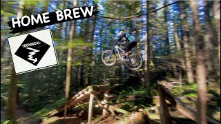
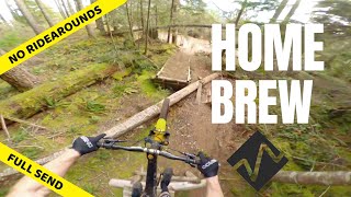
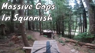
This trail features large gap jumps and skinny lines. All the jumps and log rides are optional, hence only the single black rating for the trail. If you are doing the gaps, its definitely a double black. Large gaps with high consequence.

Local Trail Association
Traditionally Indigenous Territory

Recent Activity on Trail

Past Week
  • 0 rides
  •  
6 Months
  • 6 rides
  • 13 miles avg distance
All
  • 401 rides
  • Last: Jun 3, 2026
c1c2c3c4
January
February
March
April
May
June
July
August
September
October
November
December
update trails status or condition

Home Brew Trail Reports

Status:
on Mar 1, 2026
Avg: 4.33 (21 votes)
Your vote: 0

view (2,580)
close
3D
Trail Conditions
  • Unknown
  • Snow Groomed
  • Snow Packed
  • Snow Covered
  • Snow Cover Partial
  • Freeze/thaw Cycle
  • Icy
  • Prevalent Mud
  • Wet
  • Variable
  • Ideal
  • Dry
  • Very Dry
Trail Flow (Ridden Direction)
Trailforks scans users ridelogs to determine the most popular direction each trail is ridden. A good flowing trail network will have most trails flowing in a single direction according to their intension.
The colour categories are based on what percentage of riders are riding a trail in its intended direction.
  • > 96%
  • > 90%
  • > 80%
  • > 70%
  • > 50%
  • < 50%
  • bi-directional trail
  • no data
Trail Last Ridden
Trailforks scans ridelogs to determine the last time a trail was ridden.
  • < 2 days
  • < 1 week
  • < 2 weeks
  • < 1 month
  • < 6 months
  • > 6 months
Trail Ridden Direction
The intended direction a trail should be ridden.
  • Downhill Only
  • Downhill Primary
  • Both Directions
  • Uphill Primary
  • Uphill Only
  • One Direction
Contribute Details
Colors indicate trail is missing specified detail.
  • Description
  • Photos
  • Description & Photos
  • Videos
Trail Popularity ?
Trailforks scans ridelogs to determine which trails are ridden the most in the last 9 months. Trails are compared with nearby trails in the same city region with a possible 25 colour shades. Think of this as a heatmap, more rides = more kinetic energy = warmer colors.
  • most popular
  • popular
  • less popular
  • not popular
ATV/ORV/OHV Filter
Max Vehicle Width
inches
US Cell Coverage
Legend
cell carrier legend

Radar Time
Activity Recordings
Trailforks uses anonymized public activity data. ?
Activity Recordings
Trailforks uses anonymized public activity data. ?
Personal Heatmap
Activity Types
all / none
Options
2
Date range month
Winter Trails
Warning A routing network for winter maps does not exist. Selecting trails using the winter trails layer has been disabled.
Missing Trails
Most Popular
Least Popular
Trails are colored based on popularity. The more popular a trail is, the more red. Less popular trails trend towards green.
Jump Magnitude Heatmap
Heatmap of where riders jump on trails. Zoom in to see individual jumps, click circles to view jump details.
BC Backroad Status

Service Road Atlas is a free to use, community-driven service for viewing and creating reports on the numerous back-country service roads around B.C. and Alberta.

map legend
Slope Aspect
Direction the slope faces
Flat N NE E SE S SW W NW
Trails Deemphasized
Trails are shown in grey.
disable
Only show trails with no bike usage.
Enable
Suggested Layers
Based on selected activity type

    Save the current map location and zoom level as your default home location whenever this page is loaded.

    Save
        Directions to home-brew trailhead (49.746460, -123.077980)

        Photos

        61 more »
        2,005 |
        Sep 9, 2015 @ 3:42am
        Sep 9, 2015
        719 |
        Jun 20, 2015 @ 9:06pm
        Jun 20, 2015
        18 |
        Apr 10, 2026 @ 10:04am
        Apr 10, 2026
        15 |
        Apr 10, 2026 @ 10:04am
        Apr 10, 2026

        Videos

        6 more »
        youtuber HOME BREW | Black trail | Squamish - University
        0:00 | 143 | Dec 29, 2023 , Squamish
        youtuber What Do You Do When a Trail Becomes Your NEMESIS?
        10:07 | 986 | Oct 22, 2020 , Squamish
        Home Brew into Throwdown in Squamish, BC Trail...
        0:24 | 217 | Mar 24, 2024 , Squamish
        Sending Some Big Gaps In Squamish For The...
        18:24 | 330 | Aug 27, 2021 , Squamish

        Trail Lists

        Routes with this trail

        11 miles 2,539 ft 16
        old school squamish xc loop
        4 miles 800 ft 9
        Antithesis > Cortes Planks > homebrew > Whet Yer Blade > Brodown > Phil & Cam’s
        23 miles 4,962 ft 34
        Best Double Blacks of Squamish

        7 Reviews & Comments


        We hope you've been enjoying Trailforks!

        Create a FREE account to view trail comments and much more.

        • By canadakaTF Pro Trailforks & contributors
        • #2056 - 8,851 views

        Frequently Asked Questions About Home Brew

        Where is Home Brew located?
        Home Brew is located in Diamond Head, Squamish, British Columbia, Canada. It is part of the Diamond Head trail network. The trailhead is located at coordinates 49.74646, -123.07798.
        How hard is Home Brew?
        Home Brew is rated as Black Diamond difficulty. The average grade is 11.7%.
        What is the elevation gain for Home Brew?
        Home Brew has 21 ft of elevation gain. The trail has 131 ft of elevation descent. The elevation ranges from 1,375 ft to 1,510 ft.
        Is Home Brew a point to point trail?
        Yes, Home Brew is a point to point trail. The direction is Downhill Only. The trail type is singletrack.

        Hit the Trail

        Open in App

        Get this trail on your phone instantly.
        open trail in app

        Download Trail

        Save to wishlist, Garmin & download.
        save the trail

        Find Related Routes

        Find routes and users activities that include this trail.
        find routes for this trail

        You must enter a description before submitting.