more stats
1.2 miles
Distance
23 ft
Climb
-151 ft
Descent
00:07:09
Avg time
-129 ft
Altitude change
957 ft
Altitude min
1,086 ft
Altitude max
1,086 ft
Altitude start
958 ft
Altitude end
-2.1%
Grade
-11.2%
Grade max
10%
Grade min
735 ft
Distance climb
4,163 ft
Distance down
1,253 ft
Distance flat
00:07:09
Avg time

Horny Devil Details

  • Activities
    • Mountain Bike
    • E-Bike
  • Riding Area
  • Difficulty Rating
  • Local Popularity
    100 in Mountain Biking [+]
    • 100 in E-Biking
  • Global Ranking
    #1192 in Mountain Biking [+]
    • #2487 in E-Biking
  • Trail Type
    Singletrack
  • Bike Type
    AM, XC
  • Direction
    Downhill Only[+]
    Popular Direction Shown
    • Downhill Only for E-Biking
  • Physical Rating
    Easy
  • Trail Visibility
    Always easy to follow
  • eBike Allowed
    Yes up to Class 1

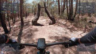
A fast flowing trail, marked with a pair of Devil's Horns (trees) at its start. The first few corners are a bit tight but it just gets faster and faster until eventually spitting you out at the Black Stump car park.

Trail Supporters
Local Trail Association
Traditionally Indigenous Territory

Recent Activity on Trail

Past Week
  • 4 rides
  • 26.2 km average
6 Months
  • 170 rides
  • 23.0 km avg distance
All
  • 2,610 rides
  • Last: Jun 16, 2026
c1c2c3c4
January
February
March
April
May
June
July
August
September
October
November
December
Status:
on Jun 7, 2026
Ideal
Avg: 4.26 (9 votes)
Your vote: 0

view (15,734)
close
3D
Trail Conditions
  • Unknown
  • Snow Groomed
  • Snow Packed
  • Snow Covered
  • Snow Cover Partial
  • Freeze/thaw Cycle
  • Icy
  • Prevalent Mud
  • Wet
  • Variable
  • Ideal
  • Dry
  • Very Dry
Trail Flow (Ridden Direction)
Trailforks scans users ridelogs to determine the most popular direction each trail is ridden. A good flowing trail network will have most trails flowing in a single direction according to their intension.
The colour categories are based on what percentage of riders are riding a trail in its intended direction.
  • > 96%
  • > 90%
  • > 80%
  • > 70%
  • > 50%
  • < 50%
  • bi-directional trail
  • no data
Trail Last Ridden
Trailforks scans ridelogs to determine the last time a trail was ridden.
  • < 2 days
  • < 1 week
  • < 2 weeks
  • < 1 month
  • < 6 months
  • > 6 months
Trail Ridden Direction
The intended direction a trail should be ridden.
  • Downhill Only
  • Downhill Primary
  • Both Directions
  • Uphill Primary
  • Uphill Only
  • One Direction
Contribute Details
Colors indicate trail is missing specified detail.
  • Description
  • Photos
  • Description & Photos
  • Videos
Trail Popularity ?
Trailforks scans ridelogs to determine which trails are ridden the most in the last 9 months. Trails are compared with nearby trails in the same city region with a possible 25 colour shades. Think of this as a heatmap, more rides = more kinetic energy = warmer colors.
  • most popular
  • popular
  • less popular
  • not popular
ATV/ORV/OHV Filter
Max Vehicle Width
inches
US Cell Coverage
Legend
cell carrier legend

Radar Time
Activity Recordings
Trailforks uses anonymized public activity data. ?
Activity Recordings
Trailforks uses anonymized public activity data. ?
Personal Heatmap
Activity Types
all / none
Options
2
Date range month
Winter Trails
Warning A routing network for winter maps does not exist. Selecting trails using the winter trails layer has been disabled.
Missing Trails
Most Popular
Least Popular
Trails are colored based on popularity. The more popular a trail is, the more red. Less popular trails trend towards green.
Jump Magnitude Heatmap
Heatmap of where riders jump on trails. Zoom in to see individual jumps, click circles to view jump details.
BC Backroad Status

Service Road Atlas is a free to use, community-driven service for viewing and creating reports on the numerous back-country service roads around B.C. and Alberta.

map legend
Slope Aspect
Direction the slope faces
Flat N NE E SE S SW W NW
Trails Deemphasized
Trails are shown in grey.
disable
Only show trails with no bike usage.
Enable
Suggested Layers
Based on selected activity type

    Save the current map location and zoom level as your default home location whenever this page is loaded.

    Save
        Directions to horny-devil trailhead (-31.977830, 116.119330)

        Photos

        6 more »
        113 |
        Jul 19, 2020 @ 12:55am
        Jul 19, 2020
        86 |
        Jul 19, 2020 @ 12:54am
        Jul 19, 2020
        73 |
        Jul 10, 2020 @ 4:35am
        Jul 10, 2020
        191 |
        Oct 31, 2019 @ 5:46pm
        Oct 31, 2019

        Videos

        2 more »
        Horny Devil  2 March 2026
        5:46 | 82 | Mar 26, 2026 , Kalamunda
        MTB Kalamunda Horny Devil
        5:40 | 31 | Dec 25, 2024 , Kalamunda

        Trail Lists

        Routes with this trail

        3.5 13 miles 1,250 ft 35
        The original loop that started it all, that has been added to much since it first opened in 2011. Most of...
        5.0 11 miles 931 ft 34
        Alternative plan for sunday afternoon ride with Bill
        4.0 17 miles 1,667 ft 50 Loop
        Camel Farm Loop with a bit of a challenge

        Reviews / Comments

        No reviews yet, be the first to write a review or ask a question.
        Use trail reports to comment on trail conditions.


        We hope you've been enjoying Trailforks!

        Create a FREE account to view trail comments and much more.

        • By BELLMACHER & contributors
        • #19422 - 4,105 views

        Frequently Asked Questions About Horny Devil

        Where is Horny Devil located?
        Horny Devil is located in Kalamunda Trail Network, Kalamunda, Australia. It is part of the Kalamunda Trail Network trail network. The trailhead is located at coordinates -31.97783, 116.11933.
        How hard is Horny Devil?
        Horny Devil is rated as Blue difficulty. The physical rating is Easy. The average grade is 2.1%.
        What is the elevation gain for Horny Devil?
        Horny Devil has 23 ft of elevation gain. The trail has 151 ft of elevation descent. The elevation ranges from 957 ft to 1,086 ft.
        Is Horny Devil a point to point trail?
        Yes, Horny Devil is a point to point trail. The direction is Downhill Only. The trail type is singletrack.

        Hit the Trail

        Open in App

        Get this trail on your phone instantly.
        open trail in app

        Download Trail

        Save to wishlist, Garmin & download.
        save the trail

        Find Related Routes

        Find routes and users activities that include this trail.
        find routes for this trail

        You must enter a description before submitting.