more stats
1,401 ft
Distance
25 ft
Climb
-156 ft
Descent
00:00:55
Avg time
-129 ft
Altitude change
834 ft
Altitude min
985 ft
Altitude max
985 ft
Altitude start
856 ft
Altitude end
-9.2%
Grade
-32.2%
Grade max
21%
Grade min
210 ft
Distance climb
984 ft
Distance down
210 ft
Distance flat
00:00:55
Avg time

Hot Lap Details

  • Activities
    • Mountain Bike
  • Riding Area
    Coast Gravity Park
    Sechelt, British Columbia
  • Difficulty Rating
  • Local Popularity
    55 in Mountain Biking
  • Global Ranking
    #76017 in Mountain Biking
  • Trail Type
    Machine Groomed
  • Bike Type
    DH, AM
  • Direction
    Downhill Only
    Popular Direction Shown
  • Dogs Allowed
    Yes

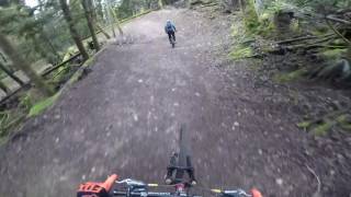
Once harnessed, Hot Lap is one of our best trails to let loose on with roller jumps and turns that offer interpretive options for how you want to shred them.

Bike Park

Traditionally Indigenous Territory

Recent Activity on Trail

Past Week
  • 0 rides
  •  
6 Months
  • 23 rides
  • 14 miles avg distance
All
  • 298 rides
  • Last: Jun 14, 2026
c1c2c3c4
January
February
March
April
May
June
July
August
September
October
November
December
Status:
on Jul 7, 2025
Dry
Avg: 4.62 (26 votes)
Your vote: 0

view (3,076)
close
3D
Trail Conditions
  • Unknown
  • Snow Groomed
  • Snow Packed
  • Snow Covered
  • Snow Cover Partial
  • Freeze/thaw Cycle
  • Icy
  • Prevalent Mud
  • Wet
  • Variable
  • Ideal
  • Dry
  • Very Dry
Trail Flow (Ridden Direction)
Trailforks scans users ridelogs to determine the most popular direction each trail is ridden. A good flowing trail network will have most trails flowing in a single direction according to their intension.
The colour categories are based on what percentage of riders are riding a trail in its intended direction.
  • > 96%
  • > 90%
  • > 80%
  • > 70%
  • > 50%
  • < 50%
  • bi-directional trail
  • no data
Trail Last Ridden
Trailforks scans ridelogs to determine the last time a trail was ridden.
  • < 2 days
  • < 1 week
  • < 2 weeks
  • < 1 month
  • < 6 months
  • > 6 months
Trail Ridden Direction
The intended direction a trail should be ridden.
  • Downhill Only
  • Downhill Primary
  • Both Directions
  • Uphill Primary
  • Uphill Only
  • One Direction
Contribute Details
Colors indicate trail is missing specified detail.
  • Description
  • Photos
  • Description & Photos
  • Videos
Trail Popularity ?
Trailforks scans ridelogs to determine which trails are ridden the most in the last 9 months. Trails are compared with nearby trails in the same city region with a possible 25 colour shades. Think of this as a heatmap, more rides = more kinetic energy = warmer colors.
  • most popular
  • popular
  • less popular
  • not popular
ATV/ORV/OHV Filter
Max Vehicle Width
inches
US Cell Coverage
Legend
cell carrier legend

Radar Time
Activity Recordings
Trailforks uses anonymized public activity data. ?
Activity Recordings
Trailforks uses anonymized public activity data. ?
Personal Heatmap
Activity Types
all / none
Options
2
Date range month
Winter Trails
Warning A routing network for winter maps does not exist. Selecting trails using the winter trails layer has been disabled.
Missing Trails
Most Popular
Least Popular
Trails are colored based on popularity. The more popular a trail is, the more red. Less popular trails trend towards green.
Jump Magnitude Heatmap
Heatmap of where riders jump on trails. Zoom in to see individual jumps, click circles to view jump details.
BC Backroad Status

Service Road Atlas is a free to use, community-driven service for viewing and creating reports on the numerous back-country service roads around B.C. and Alberta.

map legend
Slope Aspect
Direction the slope faces
Flat N NE E SE S SW W NW
Trails Deemphasized
Trails are shown in grey.
disable
Only show trails with no bike usage.
Enable
Suggested Layers
Based on selected activity type

    Save the current map location and zoom level as your default home location whenever this page is loaded.

    Save
        Directions to hot-lap trailhead (49.502360, -123.722360)

        Photos

        4 more »
        383 |
        Oct 2, 2017 @ 7:52am
        Oct 2, 2017
        343 |
        Oct 2, 2017 @ 7:51am
        Oct 2, 2017
        195 |
        Aug 24, 2014 @ 8:35pm
        Aug 24, 2014
        209 |
        Aug 24, 2014 @ 8:35pm
        Aug 24, 2014

        Videos

        13 more »
        Dirt Wave | Coast Gravity Park, BC
        9 | Jun 1, 2026 , Sechelt
        youtuber Exploring EVERY Trail at Coast Gravity Park - BC
        18:34 | 51 | May 16, 2026 , Sechelt
        First lap at Coast Grav
        5:08 | 475 | Aug 17, 2020 , Sechelt
        youtuber Hot Lap - Coast Gravity
        658 | Dec 12, 2017 , Sechelt

        1 Review & Comments


        We hope you've been enjoying Trailforks!

        Create a FREE account to view trail comments and much more.

        Frequently Asked Questions About Hot Lap

        Where is Hot Lap located?
        Hot Lap is located in Coast Gravity Park, Sechelt, British Columbia, Canada. It is part of the Coast Gravity Park trail network. The trailhead is located at coordinates 49.50236, -123.72236.
        How hard is Hot Lap?
        Hot Lap is rated as Blue difficulty. The average grade is 9.2%.
        What is the elevation gain for Hot Lap?
        Hot Lap has 25 ft of elevation gain. The trail has 156 ft of elevation descent. The elevation ranges from 834 ft to 985 ft.
        Is Hot Lap a point to point trail?
        Yes, Hot Lap is a point to point trail. The direction is Downhill Only. The trail type is machine groomed.

        Hit the Trail

        Open in App

        Get this trail on your phone instantly.
        open trail in app

        Download Trail

        Save to wishlist, Garmin & download.
        save the trail

        Find Related Routes

        Find routes and users activities that include this trail.
        find routes for this trail

        You must enter a description before submitting.