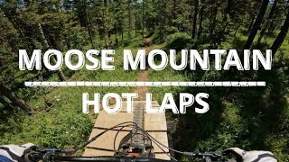
more stats
4,390 ft
Distance
-309 ft
Descent
00:12:17
Avg time
-309 ft
Altitude change
5,111 ft
Altitude min
5,419 ft
Altitude max
5,419 ft
Altitude start
5,112 ft
Altitude end
-7%
Grade
-33.3%
Grade max
-0.2%
Grade min
4,226 ft
Distance down
167 ft
Distance flat
00:12:17
Avg time

Hotlaps Details

  • Activities
    • Mountain Bike
    • E-Bike
    • Hike
    • Trail Running
  • Riding Area
    Moose Mountain
    Bragg Creek, Alberta
  • Difficulty Rating
  • Voted Difficulty
    Green (1 vote)
  • Local Popularity
    75 in Mountain Biking [+]
    • 90 in E-Biking
    • 50 in Trail Running
    • 5 in Hiking
  • Global Ranking
    #72509 in Mountain Biking [+]
    • #31972 in E-Biking
    • #118787 in Trail Running
    • #220996 in Hiking
  • Trail Type
    Singletrack
  • Direction
    Downhill Primary
    Popular Direction Shown
  • Dogs Allowed
    Yes
  • eBike Allowed
    Yes up to Class 1

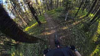
Hot Laps is a trail for the beginner rider. The trail is mostly single-track and cut line riding. The trail is all downhill and allows riders to get their first taste of downhill riding. Hot Laps is a trail “Au Naturel” all dirt baby.

Access Info

Hot Laps had drop off and pick up points both on the Moose Mt road. The trail head is located just above the 2km marker on the right hand side (just above the guard rail). The pickup is located at the Elbow Valley crossing (look for the businessman crossing sign). Its best ridden as a pedal loop for beginners - park at the 2 km lot and pedal up to the trailhead then use the road to return to 2km.

Local Trail Association

Recent Activity on Trail

Past Week
  • 5 rides
  • 16 miles average
6 Months
  • 29 rides
  • 11 miles avg distance
All
  • 305 rides
  • Last: Jun 21, 2026
c1c2c3c4
January
February
March
April
May
June
July
August
September
October
November
December
Status:
on May 11, 2026
Ideal
Avg: 3.08 (19 votes)
Your vote: 0

view (1,994)
close
3D
Trail Conditions
  • Unknown
  • Snow Groomed
  • Snow Packed
  • Snow Covered
  • Snow Cover Partial
  • Freeze/thaw Cycle
  • Icy
  • Prevalent Mud
  • Wet
  • Variable
  • Ideal
  • Dry
  • Very Dry
Trail Flow (Ridden Direction)
Trailforks scans users ridelogs to determine the most popular direction each trail is ridden. A good flowing trail network will have most trails flowing in a single direction according to their intension.
The colour categories are based on what percentage of riders are riding a trail in its intended direction.
  • > 96%
  • > 90%
  • > 80%
  • > 70%
  • > 50%
  • < 50%
  • bi-directional trail
  • no data
Trail Last Ridden
Trailforks scans ridelogs to determine the last time a trail was ridden.
  • < 2 days
  • < 1 week
  • < 2 weeks
  • < 1 month
  • < 6 months
  • > 6 months
Trail Ridden Direction
The intended direction a trail should be ridden.
  • Downhill Only
  • Downhill Primary
  • Both Directions
  • Uphill Primary
  • Uphill Only
  • One Direction
Contribute Details
Colors indicate trail is missing specified detail.
  • Description
  • Photos
  • Description & Photos
  • Videos
Trail Popularity ?
Trailforks scans ridelogs to determine which trails are ridden the most in the last 9 months. Trails are compared with nearby trails in the same city region with a possible 25 colour shades. Think of this as a heatmap, more rides = more kinetic energy = warmer colors.
  • most popular
  • popular
  • less popular
  • not popular
ATV/ORV/OHV Filter
Max Vehicle Width
inches
US Cell Coverage
Legend
cell carrier legend

Radar Time
Activity Recordings
Trailforks uses anonymized public activity data. ?
Activity Recordings
Trailforks uses anonymized public activity data. ?
Personal Heatmap
Activity Types
all / none
Options
2
Date range month
Winter Trails
Warning A routing network for winter maps does not exist. Selecting trails using the winter trails layer has been disabled.
Missing Trails
Most Popular
Least Popular
Trails are colored based on popularity. The more popular a trail is, the more red. Less popular trails trend towards green.
Jump Magnitude Heatmap
Heatmap of where riders jump on trails. Zoom in to see individual jumps, click circles to view jump details.
BC Backroad Status

Service Road Atlas is a free to use, community-driven service for viewing and creating reports on the numerous back-country service roads around B.C. and Alberta.

map legend
Slope Aspect
Direction the slope faces
Flat N NE E SE S SW W NW
Trails Deemphasized
Trails are shown in grey.
disable
Only show trails with no bike usage.
Enable
Suggested Layers
Based on selected activity type

    Save the current map location and zoom level as your default home location whenever this page is loaded.

    Save
        Directions to hotlaps trailhead (50.883420, -114.752070)

        Photos

        22 more »
        134 |
        Jul 8, 2022 @ 10:13pm
        Jul 8, 2022
        260 |
        Oct 1, 2021 @ 11:13am
        Oct 1, 2021
        354 |
        Aug 17, 2021 @ 8:53pm
        Aug 17, 2021
        285 |
        Aug 17, 2021 @ 8:53pm
        Aug 17, 2021

        Videos

        3 more »
        MMBTS Virtual Enduro RD1
        17:24 | 196 | Jun 6, 2024 , Bragg Creek
        Hot Laps [Moose Mountain]
        4:02 | 419 | May 22, 2023 , Bragg Creek
        Hotlaps - Moose Mountain MTB
        3:42 | 602 | Jul 26, 2022 , Bragg Creek

        Trail Lists

        Routes with this trail

        14 miles 2,412 ft 3 Loop
        Segment #1 Hot Laps Segment #2 Trappers DH Segment #3 Stones DH
        9 miles 1,424 ft 10 Loop
        moose mtn - 7-27
        16 miles 3,693 ft 6 Race
        Up Moose Road to Hot Laps Field entrance Race Hot Laps Up Moose Road to Family Guy entrance Race Family...

        3 Reviews & Comments


        We hope you've been enjoying Trailforks!

        Create a FREE account to view trail comments and much more.

        Frequently Asked Questions About Hotlaps

        Where is Hotlaps located?
        Hotlaps is located in Moose Mountain, Bragg Creek, Alberta, Canada. It is part of the Moose Mountain trail network. The trailhead is located at coordinates 50.88342, -114.75207.
        How hard is Hotlaps?
        Hotlaps is rated as Green difficulty. The average grade is 7%.
        What is the elevation gain for Hotlaps?
        The trail has 94 m of elevation descent. The elevation ranges from 1,558 m to 1,652 m.
        Is Hotlaps a point to point trail?
        Hotlaps is not a point to point trail. The direction is Downhill Primary. The trail type is singletrack.

        Hit the Trail

        Open in App

        Get this trail on your phone instantly.
        open trail in app

        Download Trail

        Save to wishlist, Garmin & download.
        save the trail

        Find Related Routes

        Find routes and users activities that include this trail.
        find routes for this trail

        You must enter a description before submitting.