more stats
1,837 ft
Distance
-344 ft
Descent
00:13:18
Avg time
-344 ft
Altitude change
444 ft
Altitude min
789 ft
Altitude max
789 ft
Altitude start
443 ft
Altitude end
-18.7%
Grade
-35.8%
Grade max
2.7%
Grade min
16 ft
Distance climb
1,732 ft
Distance down
89 ft
Distance flat
00:13:18
Avg time

Hueso Details

  • Activities
    • Mountain Bike
    • E-Bike
    • Observed Trials
  • Riding Area
    Alice Lake & Highlands
    Squamish, British Columbia
  • Difficulty Rating
  • Voted Difficulty
    Double Black Diamond (6 votes)
  • Local Popularity
    90 in Mountain Biking [+]
    • 90 in E-Biking
    • 60 in Observed Trials
  • Global Ranking
    #828 in Mountain Biking [+]
    • #1956 in E-Biking
    • #156 in Observed Trials
  • Trail Type
    Mixed
  • Bike Type
    DH, AM
  • Direction
    Downhill Only
    Popular Direction Shown
  • Physical Rating
    Moderate
  • Season
    Any time of year, as long as it's kinda dry.
  • Dogs Allowed
    Yes
  • eBike Allowed
    Yes up to Class 1
  • TTFs on Trail
    Drop, Rock Face
  • Year Opened
    2014

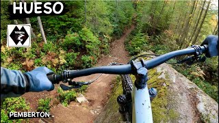
Hueso is a beautiful masterpiece of trail that goes from below where the Entrails routes end. The trail head starts about a hundred metres to the right of Gouranga, It's a series of south facing grippy rock slabs with some slightly easier panty lines on the harder sections. It's best ridden dry, but the rock is very grippy, so confident riders (who've hit the trail before) could probably ride it wet. Lower your tire pressure before dropping in.

Access Info

It’s right next to the insane Highway to Hell track; in-between Highway to Hell and 2-Stroke Smoke.

Local Trail Association
Traditionally Indigenous Territory

Recent Activity on Trail

Past Week
  • 11 rides
  • 9 miles average
6 Months
  • 114 rides
  • 10 miles avg distance
All
  • 1,199 rides
  • Last: Jun 20, 2026
c1c2c3c4
January
February
March
April
May
June
July
August
September
October
November
December
Status:
on Jun 20, 2026
Ideal
Avg: 4.71 (64 votes)
Your vote: 0

view (8,173)
close
3D
Trail Conditions
  • Unknown
  • Snow Groomed
  • Snow Packed
  • Snow Covered
  • Snow Cover Partial
  • Freeze/thaw Cycle
  • Icy
  • Prevalent Mud
  • Wet
  • Variable
  • Ideal
  • Dry
  • Very Dry
Trail Flow (Ridden Direction)
Trailforks scans users ridelogs to determine the most popular direction each trail is ridden. A good flowing trail network will have most trails flowing in a single direction according to their intension.
The colour categories are based on what percentage of riders are riding a trail in its intended direction.
  • > 96%
  • > 90%
  • > 80%
  • > 70%
  • > 50%
  • < 50%
  • bi-directional trail
  • no data
Trail Last Ridden
Trailforks scans ridelogs to determine the last time a trail was ridden.
  • < 2 days
  • < 1 week
  • < 2 weeks
  • < 1 month
  • < 6 months
  • > 6 months
Trail Ridden Direction
The intended direction a trail should be ridden.
  • Downhill Only
  • Downhill Primary
  • Both Directions
  • Uphill Primary
  • Uphill Only
  • One Direction
Contribute Details
Colors indicate trail is missing specified detail.
  • Description
  • Photos
  • Description & Photos
  • Videos
Trail Popularity ?
Trailforks scans ridelogs to determine which trails are ridden the most in the last 9 months. Trails are compared with nearby trails in the same city region with a possible 25 colour shades. Think of this as a heatmap, more rides = more kinetic energy = warmer colors.
  • most popular
  • popular
  • less popular
  • not popular
ATV/ORV/OHV Filter
Max Vehicle Width
inches
US Cell Coverage
Legend
cell carrier legend

Radar Time
Activity Recordings
Trailforks uses anonymized public activity data. ?
Activity Recordings
Trailforks uses anonymized public activity data. ?
Personal Heatmap
Activity Types
all / none
Options
2
Date range month
Winter Trails
Warning A routing network for winter maps does not exist. Selecting trails using the winter trails layer has been disabled.
Missing Trails
Most Popular
Least Popular
Trails are colored based on popularity. The more popular a trail is, the more red. Less popular trails trend towards green.
Jump Magnitude Heatmap
Heatmap of where riders jump on trails. Zoom in to see individual jumps, click circles to view jump details.
BC Backroad Status

Service Road Atlas is a free to use, community-driven service for viewing and creating reports on the numerous back-country service roads around B.C. and Alberta.

map legend
Slope Aspect
Direction the slope faces
Flat N NE E SE S SW W NW
Trails Deemphasized
Trails are shown in grey.
disable
Only show trails with no bike usage.
Enable
Suggested Layers
Based on selected activity type

    Save the current map location and zoom level as your default home location whenever this page is loaded.

    Save
        Directions to hueso-3240 trailhead (49.756760, -123.113520)

        Photos

        66 more »
        1,250 |
        Aug 7, 2017 @ 1:16am
        Aug 7, 2017
        1,009 |
        Jul 9, 2016 @ 10:26am
        Jul 9, 2016
        602 |
        Aug 7, 2017 @ 4:29pm
        Aug 7, 2017
        218 |
        Nov 3, 2023 @ 12:25pm
        Nov 3, 2023

        Videos

        36 more »
        youtuber New Bike Shakedown,
        15:19 | 856 | Feb 19, 2023 , Squamish
        youtuber He Told Me NOT To Drop This
        13:17 | 457 | Feb 25, 2023 , Squamish
        youtuber Super Tech Riding with Dangerous Dave in...
        10:33 | 1157 | Jul 3, 2017 , Squamish
        youtuber HUESO | Double black trail | Squamish - Alice Lake
        2:02 | 153 | Dec 7, 2023 , Squamish

        Articles

        Video: A Classic Squamish Slabs Lap With Remy Metailler
        Apr 17, 2020 from pinkbike.com
        Remy Metailler tackling these lines with ease.

        Routes with this trail

        3.0 11 miles 2,094 ft 37 Loop
        The toughest trails in Squamish, compiled. Try not to crash.
        5 miles 925 ft 8
        Entrails, Boney Elbows, Highway to Hell, Hueso
        6 miles 1,295 ft 8
        Entrails > Chossy > Hueso

        11 Reviews & Comments


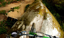
        We hope you've been enjoying Trailforks!

        Create a FREE account to view trail comments and much more.

        • By canadakaTF Pro Trailforks & contributors
        • #3240 - 21,805 views

        Frequently Asked Questions About Hueso

        Where is Hueso located?
        Hueso is located in Alice Lake & Highlands, Squamish, British Columbia, Canada. It is part of the Alice Lake & Highlands trail network. The trailhead is located at coordinates 49.75676, -123.11352.
        How hard is Hueso?
        Hueso is rated as Double Black Diamond difficulty. The physical rating is Moderate. The average grade is 18.7%.
        What is the elevation gain for Hueso?
        The trail has 344 ft of elevation descent. The elevation ranges from 444 ft to 789 ft.
        Is Hueso a point to point trail?
        Yes, Hueso is a point to point trail. The direction is Downhill Only. The trail type is mixed.

        Hit the Trail

        Open in App

        Get this trail on your phone instantly.
        open trail in app

        Download Trail

        Save to wishlist, Garmin & download.
        save the trail

        Find Related Routes

        Find routes and users activities that include this trail.
        find routes for this trail

        You must enter a description before submitting.