more stats
3,268 ft
Distance
128 ft
Climb
-175 ft
Descent
00:04:32
Avg time
-48 ft
Altitude change
3,076 ft
Altitude min
3,216 ft
Altitude max
3,124 ft
Altitude start
3,077 ft
Altitude end
-1.5%
Grade
-32.5%
Grade max
34.3%
Grade min
1,388 ft
Distance climb
1,352 ft
Distance down
528 ft
Distance flat
00:04:32
Avg time

Huff & Puff Details

  • Activities
    • Mountain Bike
    • E-Bike
    • Winter Fat Bike
    • Hike
    • Trail Running
    • Observed Trials
  • Riding Area
    Mountain Shadows
    Golden, British Columbia
  • Difficulty Rating
  • Local Popularity
    90 in Mountain Biking [+]
    • 70 in E-Biking
    • 95 in Trail Running
    • 40 in Hiking
    • 5 in Observed Trials
  • Global Ranking
    #50997 in Mountain Biking [+]
    • #72040 in E-Biking
    • #21577 in Trail Running
    • #229900 in Hiking
    • #1194 in Observed Trials
  • Trail Type
    Singletrack
  • Bike Type
    XC, Fat
  • Direction
    Both Directions
    Popular Direction Shown
  • Dogs Allowed
    Yes
  • eBike Allowed

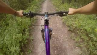
Huff & Puff would best be described as a trail that is right smack dab in the middle of the Mountain Shadows trail system. It’s very fast riding, with some exceptional cornering and short sprinty sections. The northern section of this trail is a definite favourite. It is a shared-use trail; keep and eye out for trials riders.

This trail can be broken down into two halves. The southern half runs from Kobe’s to its second junction with Magic Dragon junction (note: Huff & Puff has 2 junctions with Magic Dragon). This section rides well in either direction.

The northern half of Huff & Puff runs from the aforementioned second Magic Dragon junction to Quentin’s. This northern section of trail is best ridden in a northerly direction. Although it is technically a two-way trail, it’s best to ride that section one-way going north. This part of the trail is all about the down in open country. There are some small features on this trail, plus one gap jump, all are just off the main line. The finish of this trail is at an intersection with Quentin’s trail.

Local Trail Association
Traditionally Indigenous Territory

Recent Activity on Trail

Past Week
  • 2 rides
  • 7 miles average
6 Months
  • 42 rides
  • 9 miles avg distance
All
  • 562 rides
  • Last: Jun 23, 2026
c1c2c3c4
January
February
March
April
May
June
July
August
September
October
November
December
Status:
on May 29, 2026
Ideal
Avg: 4.06 (8 votes)
Your vote: 0

view (4,665)
close
3D
Trail Conditions
  • Unknown
  • Snow Groomed
  • Snow Packed
  • Snow Covered
  • Snow Cover Partial
  • Freeze/thaw Cycle
  • Icy
  • Prevalent Mud
  • Wet
  • Variable
  • Ideal
  • Dry
  • Very Dry
Trail Flow (Ridden Direction)
Trailforks scans users ridelogs to determine the most popular direction each trail is ridden. A good flowing trail network will have most trails flowing in a single direction according to their intension.
The colour categories are based on what percentage of riders are riding a trail in its intended direction.
  • > 96%
  • > 90%
  • > 80%
  • > 70%
  • > 50%
  • < 50%
  • bi-directional trail
  • no data
Trail Last Ridden
Trailforks scans ridelogs to determine the last time a trail was ridden.
  • < 2 days
  • < 1 week
  • < 2 weeks
  • < 1 month
  • < 6 months
  • > 6 months
Trail Ridden Direction
The intended direction a trail should be ridden.
  • Downhill Only
  • Downhill Primary
  • Both Directions
  • Uphill Primary
  • Uphill Only
  • One Direction
Contribute Details
Colors indicate trail is missing specified detail.
  • Description
  • Photos
  • Description & Photos
  • Videos
Trail Popularity ?
Trailforks scans ridelogs to determine which trails are ridden the most in the last 9 months. Trails are compared with nearby trails in the same city region with a possible 25 colour shades. Think of this as a heatmap, more rides = more kinetic energy = warmer colors.
  • most popular
  • popular
  • less popular
  • not popular
ATV/ORV/OHV Filter
Max Vehicle Width
inches
US Cell Coverage
Legend
cell carrier legend

Radar Time
Activity Recordings
Trailforks uses anonymized public activity data. ?
Activity Recordings
Trailforks uses anonymized public activity data. ?
Personal Heatmap
Activity Types
all / none
Options
2
Date range month
Winter Trails
Warning A routing network for winter maps does not exist. Selecting trails using the winter trails layer has been disabled.
Missing Trails
Most Popular
Least Popular
Trails are colored based on popularity. The more popular a trail is, the more red. Less popular trails trend towards green.
Jump Magnitude Heatmap
Heatmap of where riders jump on trails. Zoom in to see individual jumps, click circles to view jump details.
BC Backroad Status

Service Road Atlas is a free to use, community-driven service for viewing and creating reports on the numerous back-country service roads around B.C. and Alberta.

map legend
Slope Aspect
Direction the slope faces
Flat N NE E SE S SW W NW
Trails Deemphasized
Trails are shown in grey.
disable
Only show trails with no bike usage.
Enable
Suggested Layers
Based on selected activity type

    Save the current map location and zoom level as your default home location whenever this page is loaded.

    Save
        Directions to huff--puff trailhead (51.278360, -116.924620)

        Photos

        1 more »
        61 |
        Jul 6, 2024 @ 9:33pm
        Jul 6, 2024

        Videos

        1 more »
        Ride Golden Like A Girl
        8:50 | 507 | Aug 31, 2018 , Golden

        Routes with this trail

        5 miles 921 ft 4
        Join the Furious 5 Funduro!
        5 miles 772 ft 5
        Groomed fat bike trail for Winter 2021/22
        4 miles 690 ft 4 Loop
        A 6 km cross country mountain bike loop from the area.

        Reviews / Comments

        No reviews yet, be the first to write a review or ask a question.
        Use trail reports to comment on trail conditions.


        We hope you've been enjoying Trailforks!

        Create a FREE account to view trail comments and much more.

        • By canadakaTF Pro Trailforks & contributors
        • #3469 - 3,028 views

        Frequently Asked Questions About Huff & Puff

        Where is Huff & Puff located?
        Huff & Puff is located in Mountain Shadows, Golden, British Columbia, Canada. It is part of the Mountain Shadows trail network. The trailhead is located at coordinates 51.27836, -116.92462.
        How hard is Huff & Puff?
        Huff & Puff is rated as Blue difficulty. The average grade is 1.5%.
        What is the elevation gain for Huff & Puff?
        Huff & Puff has 128 ft of elevation gain. The trail has 175 ft of elevation descent. The elevation ranges from 3,076 ft to 3,216 ft.
        Is Huff & Puff a point to point trail?
        Huff & Puff is not a point to point trail. The direction is Both Directions. The trail type is singletrack.

        Hit the Trail

        Open in App

        Get this trail on your phone instantly.
        open trail in app

        Download Trail

        Save to wishlist, Garmin & download.
        save the trail

        Find Related Routes

        Find routes and users activities that include this trail.
        find routes for this trail

        You must enter a description before submitting.