more stats
2,480 ft
Distance
45 ft
Climb
-18 ft
Descent
00:06:14
Avg time
27 ft
Altitude change
523 ft
Altitude min
571 ft
Altitude max
524 ft
Altitude start
551 ft
Altitude end
1.1%
Grade
-7.9%
Grade max
11.2%
Grade min
883 ft
Distance climb
341 ft
Distance down
1,237 ft
Distance flat
00:06:14
Avg time

Humble Ninja Details

  • Activities
    • Mountain Bike
    • E-Bike
    • Hike
    • Trail Running
  • Riding Area
    The Abyss / Extension Ridge
    Nanaimo, British Columbia
  • Difficulty Rating
  • Local Popularity
    90 in Mountain Biking [+]
    • 70 in Trail Running
    • 90 in Hiking
  • Global Ranking
    #59462 in Mountain Biking [+]
    • #83306 in Trail Running
    • #38745 in Hiking
  • Trail Type
    Singletrack
  • Bike Type
    XC
  • Climb Difficulty
    Blue
  • Physical Rating
    Moderate
  • Dogs Allowed
    Yes
  • eBike Allowed
    Yes up to Class 1

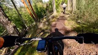
The second of two trails built to replace the logged out section of Humility it is fast and flowy. Like Secret Ninja it used sections of the old Humility trail. Fast and fun trail

Access Info

From the south end you come off of Secret Ninja and go straight across the gravel road. From the north end coming of off Keiths trail you go across the gravel road straight onto a wide single track trail. Cross a little stream and go straight ahead into the clear cut. Do not turn left.

This trail is unsanctioned.

Traditionally Indigenous Territory

Recent Activity on Trail

Past Week
  • 7 rides
  • 9 miles average
6 Months
  • 161 rides
  • 8 miles avg distance
All
  • 1,139 rides
  • Last: Jun 22, 2026
c1c2c3c4
January
February
March
April
May
June
July
August
September
October
November
December
Status:
on Apr 17, 2026
Ideal
Avg: 3.83 (12 votes)
Your vote: 0

view (4,504)
close
3D
Trail Conditions
  • Unknown
  • Snow Groomed
  • Snow Packed
  • Snow Covered
  • Snow Cover Partial
  • Freeze/thaw Cycle
  • Icy
  • Prevalent Mud
  • Wet
  • Variable
  • Ideal
  • Dry
  • Very Dry
Trail Flow (Ridden Direction)
Trailforks scans users ridelogs to determine the most popular direction each trail is ridden. A good flowing trail network will have most trails flowing in a single direction according to their intension.
The colour categories are based on what percentage of riders are riding a trail in its intended direction.
  • > 96%
  • > 90%
  • > 80%
  • > 70%
  • > 50%
  • < 50%
  • bi-directional trail
  • no data
Trail Last Ridden
Trailforks scans ridelogs to determine the last time a trail was ridden.
  • < 2 days
  • < 1 week
  • < 2 weeks
  • < 1 month
  • < 6 months
  • > 6 months
Trail Ridden Direction
The intended direction a trail should be ridden.
  • Downhill Only
  • Downhill Primary
  • Both Directions
  • Uphill Primary
  • Uphill Only
  • One Direction
Contribute Details
Colors indicate trail is missing specified detail.
  • Description
  • Photos
  • Description & Photos
  • Videos
Trail Popularity ?
Trailforks scans ridelogs to determine which trails are ridden the most in the last 9 months. Trails are compared with nearby trails in the same city region with a possible 25 colour shades. Think of this as a heatmap, more rides = more kinetic energy = warmer colors.
  • most popular
  • popular
  • less popular
  • not popular
ATV/ORV/OHV Filter
Max Vehicle Width
inches
US Cell Coverage
Legend
cell carrier legend

Radar Time
Activity Recordings
Trailforks uses anonymized public activity data. ?
Activity Recordings
Trailforks uses anonymized public activity data. ?
Personal Heatmap
Activity Types
all / none
Options
2
Date range month
Winter Trails
Warning A routing network for winter maps does not exist. Selecting trails using the winter trails layer has been disabled.
Missing Trails
Most Popular
Least Popular
Trails are colored based on popularity. The more popular a trail is, the more red. Less popular trails trend towards green.
Jump Magnitude Heatmap
Heatmap of where riders jump on trails. Zoom in to see individual jumps, click circles to view jump details.
BC Backroad Status

Service Road Atlas is a free to use, community-driven service for viewing and creating reports on the numerous back-country service roads around B.C. and Alberta.

map legend
Slope Aspect
Direction the slope faces
Flat N NE E SE S SW W NW
Trails Deemphasized
Trails are shown in grey.
disable
Only show trails with no bike usage.
Enable
Suggested Layers
Based on selected activity type

    Save the current map location and zoom level as your default home location whenever this page is loaded.

    Save
        Directions to humble-ninja trailhead (49.120830, -123.953880)

        Photos

        6 more »
        41 |
        Nov 7, 2020 @ 8:42am
        Nov 7, 2020
        207 |
        Feb 19, 2017 @ 6:49pm
        Feb 19, 2017
        280 |
        Mar 10, 2016 @ 9:57pm
        Mar 10, 2016
        43 |
        Dec 15, 2025 @ 4:26pm
        Dec 15, 2025

        Videos

        2 more »
        Humble Ninja - Abyss Nanaimo - Mar 2026
        79 | Mar 23, 2026 , Nanaimo
        Humble Ninja
        4:43 | 168 | Feb 11, 2023 , Nanaimo

        Routes with this trail

        1.5 6 miles 620 ft 14 Loop Race
        The race course is slightly revised for 2016. It will be ridden clockwise and features a mix of technical...
        123 miles 18,870 ft 510 Loop Race
        This event route is a fundraiser for Nanaimo Loaves and Fishes. Robin Dutton and Peter Sinclair will see...

        1 Review & Comments


        We hope you've been enjoying Trailforks!

        Create a FREE account to view trail comments and much more.

        • #50755 - 2,134 views

        Frequently Asked Questions About Humble Ninja

        Where is Humble Ninja located?
        Humble Ninja is located in The Abyss / Extension Ridge, Nanaimo, British Columbia, Canada. It is part of the The Abyss / Extension Ridge trail network. The trailhead is located at coordinates 49.12083, -123.95388.
        How hard is Humble Ninja?
        Humble Ninja is rated as Blue difficulty. The physical rating is Moderate. The average grade is 1.1%. The climb difficulty is rated Blue.
        What is the elevation gain for Humble Ninja?
        Humble Ninja has 45 ft of elevation gain. The trail has 18 ft of elevation descent. The elevation ranges from 523 ft to 571 ft.
        How long is Humble Ninja?
        Humble Ninja is 2,480 ft long. The trail type is singletrack.

        Hit the Trail

        Open in App

        Get this trail on your phone instantly.
        open trail in app

        Download Trail

        Save to wishlist, Garmin & download.
        save the trail

        Find Related Routes

        Find routes and users activities that include this trail.
        find routes for this trail

        You must enter a description before submitting.