more stats
2,057 ft
Distance
-205 ft
Descent
00:02:52
Avg time
-205 ft
Altitude change
840 ft
Altitude min
1,045 ft
Altitude max
1,045 ft
Altitude start
840 ft
Altitude end
-10%
Grade
-19.5%
Grade max
-2%
Grade min
1,952 ft
Distance down
105 ft
Distance flat
00:02:52
Avg time

Hustler Details

  • Activities
    • Mountain Bike
    • Hike
    • Trail Running
  • Riding Area
    Burke Mountain
    Coquitlam, British Columbia
  • Difficulty Rating
  • Voted Difficulty
    Blue (1 vote)
  • Local Popularity
    100 in Mountain Biking [+]
    • 90 in Trail Running
    • 95 in Hiking
  • Global Ranking
    #14982 in Mountain Biking [+]
    • #601 in Trail Running
    • #1480 in Hiking
  • Hiking SAC Scale
    T1 Hiking
  • Trail Type
    Singletrack
  • Bike Type
    AM, XC
  • Direction
    Downhill Primary
    Popular Direction Shown
  • Climb Difficulty
    Green
  • Physical Rating
    Moderate
  • Trail Visibility
    Always easy to follow
  • Family Friendly
    Yes
  • Dogs Allowed
    Yes
  • Land Owner
    Wesbild

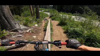
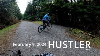
Hustler is one of the most accessible trails on Burke Mountain. Sightlines are good and there are many easier features (low bridges, rock gardens and rooty sections) to progress your skills on. Popular when the snowline is low and to introduce novice riders to proper mountain biking. Also very scenic around sunset

Access Info

Hustler exits on Harper Road above the hairpin. Franks now leads into the old bottom section of Hustler, which one climbs up to the new Hustler exit. These reroutes were created, in cooperation with Wesbild, to prevent mountain bikers conflicting with the new road construction near the hairpin corner of Harper.

This trail is unsanctioned.

Recent Activity on Trail

Past Week
  • 12 rides
  • 5 miles average
6 Months
  • 251 rides
  • 6 miles avg distance
All
  • 3,551 rides
  • Last: Jun 20, 2026
c1c2c3c4
January
February
March
April
May
June
July
August
September
October
November
December
Status:
on Jun 20, 2026
Very Dry
Avg: 3.6 (46 votes)
Your vote: 0

view (19,268)
close
3D
Trail Conditions
  • Unknown
  • Snow Groomed
  • Snow Packed
  • Snow Covered
  • Snow Cover Partial
  • Freeze/thaw Cycle
  • Icy
  • Prevalent Mud
  • Wet
  • Variable
  • Ideal
  • Dry
  • Very Dry
Trail Flow (Ridden Direction)
Trailforks scans users ridelogs to determine the most popular direction each trail is ridden. A good flowing trail network will have most trails flowing in a single direction according to their intension.
The colour categories are based on what percentage of riders are riding a trail in its intended direction.
  • > 96%
  • > 90%
  • > 80%
  • > 70%
  • > 50%
  • < 50%
  • bi-directional trail
  • no data
Trail Last Ridden
Trailforks scans ridelogs to determine the last time a trail was ridden.
  • < 2 days
  • < 1 week
  • < 2 weeks
  • < 1 month
  • < 6 months
  • > 6 months
Trail Ridden Direction
The intended direction a trail should be ridden.
  • Downhill Only
  • Downhill Primary
  • Both Directions
  • Uphill Primary
  • Uphill Only
  • One Direction
Contribute Details
Colors indicate trail is missing specified detail.
  • Description
  • Photos
  • Description & Photos
  • Videos
Trail Popularity ?
Trailforks scans ridelogs to determine which trails are ridden the most in the last 9 months. Trails are compared with nearby trails in the same city region with a possible 25 colour shades. Think of this as a heatmap, more rides = more kinetic energy = warmer colors.
  • most popular
  • popular
  • less popular
  • not popular
ATV/ORV/OHV Filter
Max Vehicle Width
inches
US Cell Coverage
Legend
cell carrier legend

Radar Time
Activity Recordings
Trailforks uses anonymized public activity data. ?
Activity Recordings
Trailforks uses anonymized public activity data. ?
Personal Heatmap
Activity Types
all / none
Options
2
Date range month
Winter Trails
Warning A routing network for winter maps does not exist. Selecting trails using the winter trails layer has been disabled.
Missing Trails
Most Popular
Least Popular
Trails are colored based on popularity. The more popular a trail is, the more red. Less popular trails trend towards green.
Jump Magnitude Heatmap
Heatmap of where riders jump on trails. Zoom in to see individual jumps, click circles to view jump details.
BC Backroad Status

Service Road Atlas is a free to use, community-driven service for viewing and creating reports on the numerous back-country service roads around B.C. and Alberta.

map legend
Slope Aspect
Direction the slope faces
Flat N NE E SE S SW W NW
Trails Deemphasized
Trails are shown in grey.
disable
Only show trails with no bike usage.
Enable
Suggested Layers
Based on selected activity type

    Save the current map location and zoom level as your default home location whenever this page is loaded.

    Save
        Directions to hustler trailhead (49.308380, -122.744440)

        Photos

        48 more »
        6 |
        Jun 14, 2026 @ 1:03pm
        Jun 14, 2026
        89 |
        Nov 27, 2023 @ 3:03pm
        Nov 27, 2023
        187 |
        Apr 15, 2021 @ 1:45am
        Apr 15, 2021
        114 |
        Nov 22, 2019 @ 2:57pm
        Nov 22, 2019

        Videos

        27 more »
        Green Hustler - Burke Mountain
        5:02 | 150 | Aug 28, 2024 , Coquitlam
        HUSTLER Feb 9, 2024
        0:56 | 246 | Feb 11, 2024 , Coquitlam
        Burke - Hustler
        3:10 | 320 | May 20, 2023 , Coquitlam
        Burke Mountain Blue Flow Trails Racing the Sunset
        7:40 | 273 | Oct 24, 2022 , Coquitlam

        Routes with this trail

        5.0 5 miles 1,432 ft 7
        Some of the best trails on lower burke.
        3 miles 616 ft 8
        This route is going to pose a technical challenge to grade 8 riders. At nearly 5 km, it is a bit shorter...
        2.0 6 miles 1,628 ft 10
        The climb out of the start gate and up gravel pitches of 20% at its steepest will test the legs of BC's...

        Trail Products

        6 Reviews & Comments


        We hope you've been enjoying Trailforks!

        Create a FREE account to view trail comments and much more.

        • #914 - 10,108 views

        Frequently Asked Questions About Hustler

        Where is Hustler located?
        Hustler is located in Burke Mountain, Coquitlam, British Columbia, Canada. It is part of the Burke Mountain trail network. The trailhead is located at coordinates 49.30838, -122.74444.
        How hard is Hustler?
        Hustler is rated as Blue difficulty. The physical rating is Moderate. The average grade is 10%. The climb difficulty is rated Green.
        What is the elevation gain for Hustler?
        The trail has 205 ft of elevation descent. The elevation ranges from 840 ft to 1,045 ft.
        Is Hustler a point to point trail?
        Hustler is not a point to point trail. The direction is Downhill Primary. The trail type is singletrack.

        Hit the Trail

        Open in App

        Get this trail on your phone instantly.
        open trail in app

        Download Trail

        Save to wishlist, Garmin & download.
        save the trail

        Find Related Routes

        Find routes and users activities that include this trail.
        find routes for this trail

        You must enter a description before submitting.