more stats
3,163 ft
Distance
-182 ft
Descent
00:05:08
Avg time
-182 ft
Altitude change
6,143 ft
Altitude min
6,325 ft
Altitude max
6,325 ft
Altitude start
6,145 ft
Altitude end
-5.7%
Grade
-24%
Grade max
-1.2%
Grade min
3,163 ft
Distance down
00:05:08
Avg time

Hydroplant Details

  • Activities
    • Mountain Bike
    • E-Bike
    • Horse
    • Hike
    • Trail Running
    • Dirtbike/Moto
  • Riding Area
    Bald Mountain Ephraim
    Ephraim, Utah
  • Difficulty Rating
  • Local Popularity
    75 in Mountain Biking [+]
    • 5 in E-Biking
    • 95 in Trail Running
    • 5 in Hiking
    • 5 in Dirtbiking
    • 5 in Horseback
  • Global Ranking
    #103671 in Mountain Biking [+]
    • #171319 in E-Biking
    • #33975 in Trail Running
    • #265558 in Hiking
    • #4337 in Dirtbiking
    • #4171 in Horseback
  • Hiking SAC Scale
    T1 Hiking
  • Trail Type
    Singletrack
  • Bike Type
    DH, AM, XC
  • Direction
    Both Directions
  • Dogs Allowed
    Yes
  • eBike Allowed
    Yes up to Class 1

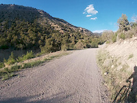
This trail starts out as a fourhweeler trail when you are traveling from west to east. About midway through the trail their are ton of rock of to the side of the trail. I’ve hit my pedal many time, so be warned. The rest is fairly straight forward. Not really any features like jumps or berms.

Access Info

Head the Main Canyon road, turn left onto New Canyon about 300-400 feet. Trail head on the left.

Trail Supporters
  • Sponsor

Recent Activity on Trail

Past Week
  • 0 rides
  •  
6 Months
  • 0 rides
  •  
All
  • 11 rides
  • Last: Oct 21, 2025
c1c2c3c4
January
February
March
April
May
June
July
August
September
October
November
December
update trails status or condition

Hydroplant Trail Reports

statusdatedescription
Jul 26, 2025 @ 10:06pm
Jul 26, 2025
Double track to single track that’s overgrown. Not worth the effort.
Aug 9, 2022 @ 5:31pm
Aug 9, 2022
It's very overgrown as usual, and rocky as usual.
Jul 16, 2020 @ 11:11am
Jul 16, 2020
This trail is overgrown due to lack of use. be careful because the tall grass and rocks make for a more difficult ride.
Jun 15, 2020 @ 2:21pm
Jun 15, 2020
Jun 3, 2020 @ 12:34am
Jun 3, 2020
Nice path but beware some of the rocks can catch you off guard on some parts
more »
Status:
on Jul 26, 2025
Dry
Avg: 3.54 (5 votes)
Your vote: 0

view (99)
close
3D
Trail Conditions
  • Unknown
  • Snow Groomed
  • Snow Packed
  • Snow Covered
  • Snow Cover Partial
  • Freeze/thaw Cycle
  • Icy
  • Prevalent Mud
  • Wet
  • Variable
  • Ideal
  • Dry
  • Very Dry
Trail Flow (Ridden Direction)
Trailforks scans users ridelogs to determine the most popular direction each trail is ridden. A good flowing trail network will have most trails flowing in a single direction according to their intension.
The colour categories are based on what percentage of riders are riding a trail in its intended direction.
  • > 96%
  • > 90%
  • > 80%
  • > 70%
  • > 50%
  • < 50%
  • bi-directional trail
  • no data
Trail Last Ridden
Trailforks scans ridelogs to determine the last time a trail was ridden.
  • < 2 days
  • < 1 week
  • < 2 weeks
  • < 1 month
  • < 6 months
  • > 6 months
Trail Ridden Direction
The intended direction a trail should be ridden.
  • Downhill Only
  • Downhill Primary
  • Both Directions
  • Uphill Primary
  • Uphill Only
  • One Direction
Contribute Details
Colors indicate trail is missing specified detail.
  • Description
  • Photos
  • Description & Photos
  • Videos
Trail Popularity ?
Trailforks scans ridelogs to determine which trails are ridden the most in the last 9 months. Trails are compared with nearby trails in the same city region with a possible 25 colour shades. Think of this as a heatmap, more rides = more kinetic energy = warmer colors.
  • most popular
  • popular
  • less popular
  • not popular
ATV/ORV/OHV Filter
Max Vehicle Width
inches
US Cell Coverage
Legend
cell carrier legend

Radar Time
Activity Recordings
Trailforks uses anonymized public activity data. ?
Activity Recordings
Trailforks uses anonymized public activity data. ?
Personal Heatmap
Activity Types
all / none
Options
2
Date range month
Winter Trails
Warning A routing network for winter maps does not exist. Selecting trails using the winter trails layer has been disabled.
Missing Trails
Most Popular
Least Popular
Trails are colored based on popularity. The more popular a trail is, the more red. Less popular trails trend towards green.
Jump Magnitude Heatmap
Heatmap of where riders jump on trails. Zoom in to see individual jumps, click circles to view jump details.
BC Backroad Status

Service Road Atlas is a free to use, community-driven service for viewing and creating reports on the numerous back-country service roads around B.C. and Alberta.

map legend
Slope Aspect
Direction the slope faces
Flat N NE E SE S SW W NW
Trails Deemphasized
Trails are shown in grey.
disable
Only show trails with no bike usage.
Enable
Suggested Layers
Based on selected activity type

    Save the current map location and zoom level as your default home location whenever this page is loaded.

    Save
        Directions to hydroplant trailhead (39.340540, -111.536670)

        Photos

        No photos have been added for Hydroplant yet, add a photo.

        Videos

        2 more »
        Hydro-plant
        3:29 | 202 | May 29, 2020 , Ephraim
        Hydroplant
        3:28 | 37 | May 29, 2020 , Ephraim

        Routes with this trail

        1.0 7 miles 110 ft 7 Point to Point
        A fun way to go down Ephraim canyon using only blue trials

        1 Review & Comments


        We hope you've been enjoying Trailforks!

        Create a FREE account to view trail comments and much more.

        • By toddTF Pro Trailforks & contributors
        • #92760 - 925 views

        Frequently Asked Questions About Hydroplant

        Where is Hydroplant located?
        Hydroplant is located in Bald Mountain Ephraim, Ephraim, Utah, United States. It is part of the Bald Mountain Ephraim trail network. The trailhead is located at coordinates 39.34054, -111.53667.
        How hard is Hydroplant?
        Hydroplant is rated as Blue difficulty. The average grade is 5.7%.
        What is the elevation gain for Hydroplant?
        The trail has 182 ft of elevation descent. The elevation ranges from 6,143 ft to 6,325 ft.
        Is Hydroplant a point to point trail?
        Hydroplant is not a point to point trail. The direction is Both Directions. The trail type is singletrack.

        Hit the Trail

        Open in App

        Get this trail on your phone instantly.
        open trail in app

        Download Trail

        Save to wishlist, Garmin & download.
        save the trail

        Find Related Routes

        Find routes and users activities that include this trail.
        find routes for this trail

        You must enter a description before submitting.