more stats
1.5 miles
Distance
88 ft
Climb
-644 ft
Descent
00:07:55
Avg time
-555 ft
Altitude change
400 ft
Altitude min
956 ft
Altitude max
956 ft
Altitude start
400 ft
Altitude end
-7.2%
Grade
-47.1%
Grade max
17.7%
Grade min
1,444 ft
Distance climb
1 mile
Distance down
400 ft
Distance flat
00:07:55
Avg time

Ikigai Details

  • Activities
    • Mountain Bike
    • E-Bike
    • Winter Fat Bike
  • Riding Area
    Waimapihi Reserve
    Wellington
  • Difficulty Rating
  • Voted Difficulty
    Blue (4 votes)
  • Local Popularity
    95 in Mountain Biking [+]
    • 85 in E-Biking
  • Global Ranking
    #292 in Mountain Biking [+]
    • #1834 in E-Biking
  • Trail Type
    Singletrack
  • Bike Type
    DH, AM, XC, DJ, Fat, CX
  • Direction
    Downhill Only
    Popular Direction Shown
  • Trail Visibility
    Always easy to follow
  • Dogs Allowed
    Yes
  • eBike Allowed
    Yes up to Class 1
  • Year Opened
    2020
  • Land Owner
    WCC

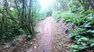
Brooklyn Trail Builders are pleased to announce that Ikigai (pronounced ee-key-guy) is now open and ridable top to bottom. Ikigai is a Japanese word and roughly translates to the ‘realisation of the life one expects and hopes for’. This sums up many of the values the volunteers who built the trail aspire to. The trail took 2 years and 7 months of volunteer time to build.

Please take care as Ikigai crosses three other trails when descending The crossings are signposted.

Please note there will be ongoing tweaking, general maintenance and native tree planting on Ikigai. If you happen to be out riding and see an orange cone on the trail, a flashing light or a fluro vest hanging in your ride line, please slow down as someone will be working close by!

Access Info

The entrance to Ikigai is on the fenceline, between Sawmill to the south and the beginning of the Rollercoaster to the north.

Disclaimer

Please note there will be ongoing maintenance and tree planting on Ikigai. If you happen to be out riding and see an orange cone on the trail, or a fluro vest hanging in your ride line, please slow down as someone will be close by!

Local Trail Association

Recent Activity on Trail

Past Week
  • 12 rides
  • 11 miles average
6 Months
  • 236 rides
  • 13 miles avg distance
All
  • 1,804 rides
  • Last: Jun 19, 2026
c1c2c3c4
January
February
March
April
May
June
July
August
September
October
November
December
update trails status or condition

Ikigai Trail Reports

statusdatedescription
May 25, 2026 @ 6:22am (Pacific/Auckland)
May 24, 2026
Still a bit wet in places from recent rain and the limited sun / wind to dry the trial out.
May 5, 2026 @ 4:54pm (Pacific/Auckland)
May 4, 2026
May 3, 2026 @ 1:39pm (Pacific/Auckland)
May 2, 2026
Apr 5, 2026 @ 8:19am (Pacific/Auckland)
Apr 4, 2026
Mar 18, 2026 @ 6:28am (Pacific/Auckland)
Mar 17, 2026
Some of the rocks and roots were a bit slippery. Dicey on (old) XC tyres....
more »
Status:
on May 25, 2026
Variable
Avg: 4.68 (28 votes)
Your vote: 0

view (16,879)
close
3D
Trail Conditions
  • Unknown
  • Snow Groomed
  • Snow Packed
  • Snow Covered
  • Snow Cover Partial
  • Freeze/thaw Cycle
  • Icy
  • Prevalent Mud
  • Wet
  • Variable
  • Ideal
  • Dry
  • Very Dry
Trail Flow (Ridden Direction)
Trailforks scans users ridelogs to determine the most popular direction each trail is ridden. A good flowing trail network will have most trails flowing in a single direction according to their intension.
The colour categories are based on what percentage of riders are riding a trail in its intended direction.
  • > 96%
  • > 90%
  • > 80%
  • > 70%
  • > 50%
  • < 50%
  • bi-directional trail
  • no data
Trail Last Ridden
Trailforks scans ridelogs to determine the last time a trail was ridden.
  • < 2 days
  • < 1 week
  • < 2 weeks
  • < 1 month
  • < 6 months
  • > 6 months
Trail Ridden Direction
The intended direction a trail should be ridden.
  • Downhill Only
  • Downhill Primary
  • Both Directions
  • Uphill Primary
  • Uphill Only
  • One Direction
Contribute Details
Colors indicate trail is missing specified detail.
  • Description
  • Photos
  • Description & Photos
  • Videos
Trail Popularity ?
Trailforks scans ridelogs to determine which trails are ridden the most in the last 9 months. Trails are compared with nearby trails in the same city region with a possible 25 colour shades. Think of this as a heatmap, more rides = more kinetic energy = warmer colors.
  • most popular
  • popular
  • less popular
  • not popular
ATV/ORV/OHV Filter
Max Vehicle Width
inches
US Cell Coverage
Legend
cell carrier legend

Radar Time
Activity Recordings
Trailforks uses anonymized public activity data. ?
Activity Recordings
Trailforks uses anonymized public activity data. ?
Personal Heatmap
Activity Types
all / none
Options
2
Date range month
Winter Trails
Warning A routing network for winter maps does not exist. Selecting trails using the winter trails layer has been disabled.
Missing Trails
Most Popular
Least Popular
Trails are colored based on popularity. The more popular a trail is, the more red. Less popular trails trend towards green.
Jump Magnitude Heatmap
Heatmap of where riders jump on trails. Zoom in to see individual jumps, click circles to view jump details.
BC Backroad Status

Service Road Atlas is a free to use, community-driven service for viewing and creating reports on the numerous back-country service roads around B.C. and Alberta.

map legend
Slope Aspect
Direction the slope faces
Flat N NE E SE S SW W NW
Trails Deemphasized
Trails are shown in grey.
disable
Only show trails with no bike usage.
Enable
Suggested Layers
Based on selected activity type

    Save the current map location and zoom level as your default home location whenever this page is loaded.

    Save
        Directions to ikigai trailhead (-41.302610, 174.749510)

        Photos

        14 more »
        40 |
        Feb 27, 2026 @ 3:32pm
        Feb 27, 2026
        28 |
        Feb 27, 2026 @ 3:31pm
        Feb 27, 2026
        48 |
        May 15, 2022 @ 8:57pm
        May 15, 2022
        68 |
        May 15, 2022 @ 8:57pm
        May 15, 2022

        Videos

        16 more »
        youtuber FAST FLOW - Ikigai (Spuds) Mountain Bike Trail...
        6:10 | 1608 | Aug 8, 2020 , Wellington
        youtuber Ikigai Part 1 @ Polhil Reserve  4K
        0:28 | 632 | Nov 11, 2018 , Wellington
        youtuber Ikigai @ Polhil Reserve
        6:44 | 555 | Jun 2, 2020 , Wellington
        IKIGAI AT NIGHT - Grade 3 (Intermediate),...
        6:29 | 150 | Jun 10, 2024 , Wellington

        Routes with this trail

        5.0 5 miles 638 ft 4
        New meta (Start from Newtown as well).
        22 miles 4,097 ft 19 Point to Point
        The Wellington Urban Classic is a social group ride that showcases some of the awesome trails across...
        22 miles 4,097 ft 19 Point to Point
        The Wellington Urban Classic is a social group ride that showcases some of the awesome trails across...

        12 Reviews & Comments


        We hope you've been enjoying Trailforks!

        Create a FREE account to view trail comments and much more.

        • By gristlybits BTB & contributors
        • #127647 - 14,155 views

        Frequently Asked Questions About Ikigai

        Where is Ikigai located?
        Ikigai is located in Waimapihi Reserve, Wellington, New Zealand. It is part of the Waimapihi Reserve trail network. The trailhead is located at coordinates -41.30261, 174.74951.
        How hard is Ikigai?
        Ikigai is rated as Blue difficulty. The average grade is 7.2%.
        What is the elevation gain for Ikigai?
        Ikigai has 88 ft of elevation gain. The trail has 644 ft of elevation descent. The elevation ranges from 400 ft to 956 ft.
        Is Ikigai a point to point trail?
        Yes, Ikigai is a point to point trail. The direction is Downhill Only. The trail type is singletrack.

        Hit the Trail

        Open in App

        Get this trail on your phone instantly.
        open trail in app

        Download Trail

        Save to wishlist, Garmin & download.
        save the trail

        Find Related Routes

        Find routes and users activities that include this trail.
        find routes for this trail

        You must enter a description before submitting.