more stats
1.6 miles
Distance
-1,752 ft
Descent
00:59:03
Avg time
-1,752 ft
Altitude change
4,261 ft
Altitude min
6,013 ft
Altitude max
6,013 ft
Altitude start
4,262 ft
Altitude end
-20.1%
Grade
-66.6%
Grade max
-1.6%
Grade min
2 miles
Distance down
00:59:03
Avg time

Il Passone Details

  • Activities
    • Mountain Bike
    • E-Bike
    • Winter Fat Bike
    • Hike
    • Trail Running
  • Riding Area
    Monte Cusna
    Febbio
  • Ref Number
    615-000
  • Difficulty Rating
  • Voted Difficulty
    Proline (1 vote)
  • Local Popularity
    45 in Mountain Biking [+]
    • 5 in E-Biking
    • 100 in Trail Running
    • 100 in Hiking
  • Global Ranking
    #103604 in Mountain Biking [+]
    • #108612 in E-Biking
    • #5621 in Trail Running
    • #6143 in Hiking
  • Trail Type
    Singletrack
  • Bike Type
    DH, AM, Fat
  • Direction
    Downhill Only
    Popular Direction Shown
  • Physical Rating
    Hard
  • Trail Visibility
    Always easy to follow
  • Alpine Trail
    Yes
  • eBike Allowed
  • Land Owner
    Ride The Giant ASD

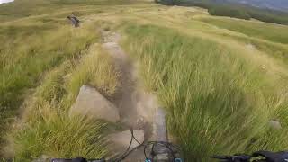
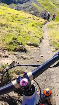
Sentiero molto tecnico e ripido con alcuni tratti esposti all'inizio. Qualche passaggio con bici al fianco.
Very technical end steep trail with some exposed sections in the beginning. Some little sections with bike by side.

Access Info

Dal Passone prendere il sentiero 615 in direzione Nord.
From Passone take trail 615 direction North.

Trail Supporters

Recent Activity on Trail

Past Week
  • 0 rides
  •  
6 Months
  • 0 rides
  •  
All
  • 3 rides
  • Last: Jul 29, 2025
c1c2c3c4
January
February
March
April
May
June
July
August
September
October
November
December
update trails status or condition

Il Passone Trail Reports

statusdatedescription
Jun 1, 2025 @ 9:40am
Jun 1, 2025
Aug 25, 2024 @ 1:37pm
Aug 25, 2024
Parte iniziale con molti sassi smossi portati dagli ultimi temporali. il resto buone condizioni. Comunque Impegnativo
Aug 20, 2023 @ 12:45am
Aug 20, 2023
Aug 6, 2023 @ 8:55am
Aug 6, 2023
buone condizioni, micidiale fisicamente. Solo per esperti del tecnico con abilità trialistiche
Jul 26, 2023 @ 11:30am
Jul 26, 2023
condizioni ottime, Trail perfetto!
more »
Status:
on Jun 1, 2025
Dry
Avg: 4.13 (1 votes)
Your vote: 0

view (44)
close
3D
Trail Conditions
  • Unknown
  • Snow Groomed
  • Snow Packed
  • Snow Covered
  • Snow Cover Partial
  • Freeze/thaw Cycle
  • Icy
  • Prevalent Mud
  • Wet
  • Variable
  • Ideal
  • Dry
  • Very Dry
Trail Flow (Ridden Direction)
Trailforks scans users ridelogs to determine the most popular direction each trail is ridden. A good flowing trail network will have most trails flowing in a single direction according to their intension.
The colour categories are based on what percentage of riders are riding a trail in its intended direction.
  • > 96%
  • > 90%
  • > 80%
  • > 70%
  • > 50%
  • < 50%
  • bi-directional trail
  • no data
Trail Last Ridden
Trailforks scans ridelogs to determine the last time a trail was ridden.
  • < 2 days
  • < 1 week
  • < 2 weeks
  • < 1 month
  • < 6 months
  • > 6 months
Trail Ridden Direction
The intended direction a trail should be ridden.
  • Downhill Only
  • Downhill Primary
  • Both Directions
  • Uphill Primary
  • Uphill Only
  • One Direction
Contribute Details
Colors indicate trail is missing specified detail.
  • Description
  • Photos
  • Description & Photos
  • Videos
Trail Popularity ?
Trailforks scans ridelogs to determine which trails are ridden the most in the last 9 months. Trails are compared with nearby trails in the same city region with a possible 25 colour shades. Think of this as a heatmap, more rides = more kinetic energy = warmer colors.
  • most popular
  • popular
  • less popular
  • not popular
ATV/ORV/OHV Filter
Max Vehicle Width
inches
US Cell Coverage
Legend
cell carrier legend

Radar Time
Activity Recordings
Trailforks uses anonymized public activity data. ?
Activity Recordings
Trailforks uses anonymized public activity data. ?
Personal Heatmap
Activity Types
all / none
Options
2
Date range month
Winter Trails
Warning A routing network for winter maps does not exist. Selecting trails using the winter trails layer has been disabled.
Missing Trails
Most Popular
Least Popular
Trails are colored based on popularity. The more popular a trail is, the more red. Less popular trails trend towards green.
Jump Magnitude Heatmap
Heatmap of where riders jump on trails. Zoom in to see individual jumps, click circles to view jump details.
BC Backroad Status

Service Road Atlas is a free to use, community-driven service for viewing and creating reports on the numerous back-country service roads around B.C. and Alberta.

map legend
Slope Aspect
Direction the slope faces
Flat N NE E SE S SW W NW
Trails Deemphasized
Trails are shown in grey.
disable
Only show trails with no bike usage.
Enable
Suggested Layers
Based on selected activity type

    Save the current map location and zoom level as your default home location whenever this page is loaded.

    Save
        Directions to il-passone trailhead (44.269480, 10.421980)

        Photos

        7 more »
        34 |
        Jul 3, 2024 @ 10:14am
        Jul 3, 2024
        30 |
        Jul 3, 2024 @ 10:13am
        Jul 3, 2024
        51 |
        Sep 26, 2023 @ 3:34am
        Sep 26, 2023
        40 |
        Sep 14, 2023 @ 3:25am
        Sep 14, 2023

        Videos

        2 more »
        Il Passone, Monte Cusna
        18:47 | 217 | Sep 1, 2023 , Febbio
        Epic ride - Costa delle Veline + Passone
        0:42 | 69 | May 8, 2023 , Febbio

        1 Review & Comments


        We hope you've been enjoying Trailforks!

        Create a FREE account to view trail comments and much more.

        • By Baluba64TF Pro GMTBL & contributors
        • #213511 - 864 views

        Frequently Asked Questions About Il Passone

        Where is Il Passone located?
        Il Passone is located in Monte Cusna, Febbio, Italy. It is part of the Monte Cusna trail network. The trailhead is located at coordinates 44.26948, 10.42198.
        How hard is Il Passone?
        Il Passone is rated as Black difficulty. The physical rating is Hard. The average grade is 20.1%.
        What is the elevation gain for Il Passone?
        The trail has 534 m of elevation descent. The elevation ranges from 1,299 m to 1,833 m.
        Is Il Passone a point to point trail?
        Yes, Il Passone is a point to point trail. The direction is Downhill Only. The trail type is singletrack.

        Hit the Trail

        Open in App

        Get this trail on your phone instantly.
        open trail in app

        Download Trail

        Save to wishlist, Garmin & download.
        save the trail

        Find Related Routes

        Find routes and users activities that include this trail.
        find routes for this trail

        You must enter a description before submitting.