more stats
2,920 ft
Distance
5 ft
Climb
-526 ft
Descent
00:09:36
Avg time
-521 ft
Altitude change
3,912 ft
Altitude min
4,440 ft
Altitude max
4,439 ft
Altitude start
3,917 ft
Altitude end
-17.9%
Grade
-52.5%
Grade max
9.1%
Grade min
184 ft
Distance climb
2,533 ft
Distance down
203 ft
Distance flat
00:09:36
Avg time

In Deep Details

  • Activities
    • Mountain Bike
  • Riding Area
    Whistler Mountain Bike Park
    Whistler, British Columbia
  • Difficulty Rating
  • Voted Difficulty
    Double Black Diamond (4 votes)
  • Local Popularity
    35 in Mountain Biking
  • Global Ranking
    #36370 in Mountain Biking
  • Trail Type
    Singletrack
  • Bike Type
    DH
  • Direction
    Downhill Only
    Popular Direction Shown
  • Land Owner

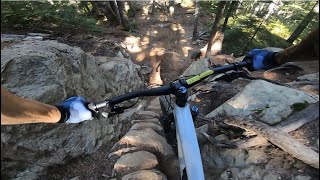
Maybe the hardest technical trail on the mountain. This tech trail has it all: rock rolls, a long skinny, tons of roots and rocks, steeps, drops, ladder jumps and a few steep chunky switchbacks. It is a relentless techfest from start to finish with most extreme sections offering an easier line - but not too easy

Bike Park

Recent Activity on Trail

Past Week
  • 24 rides
  • 28 miles average
6 Months
  • 24 rides
  • 28 miles avg distance
All
  • 815 rides
  • Last: Jun 17, 2026
c1c2c3c4
January
February
March
April
May
June
July
August
September
October
November
December
update trails status or condition

In Deep Trail Reports

Status:
on Jun 14, 2026
Ideal
Avg: 4.75 (58 votes)
Your vote: 0

view (5,468)
close
3D
Trail Conditions
  • Unknown
  • Snow Groomed
  • Snow Packed
  • Snow Covered
  • Snow Cover Partial
  • Freeze/thaw Cycle
  • Icy
  • Prevalent Mud
  • Wet
  • Variable
  • Ideal
  • Dry
  • Very Dry
Trail Flow (Ridden Direction)
Trailforks scans users ridelogs to determine the most popular direction each trail is ridden. A good flowing trail network will have most trails flowing in a single direction according to their intension.
The colour categories are based on what percentage of riders are riding a trail in its intended direction.
  • > 96%
  • > 90%
  • > 80%
  • > 70%
  • > 50%
  • < 50%
  • bi-directional trail
  • no data
Trail Last Ridden
Trailforks scans ridelogs to determine the last time a trail was ridden.
  • < 2 days
  • < 1 week
  • < 2 weeks
  • < 1 month
  • < 6 months
  • > 6 months
Trail Ridden Direction
The intended direction a trail should be ridden.
  • Downhill Only
  • Downhill Primary
  • Both Directions
  • Uphill Primary
  • Uphill Only
  • One Direction
Contribute Details
Colors indicate trail is missing specified detail.
  • Description
  • Photos
  • Description & Photos
  • Videos
Trail Popularity ?
Trailforks scans ridelogs to determine which trails are ridden the most in the last 9 months. Trails are compared with nearby trails in the same city region with a possible 25 colour shades. Think of this as a heatmap, more rides = more kinetic energy = warmer colors.
  • most popular
  • popular
  • less popular
  • not popular
ATV/ORV/OHV Filter
Max Vehicle Width
inches
US Cell Coverage
Legend
cell carrier legend

Radar Time
Activity Recordings
Trailforks uses anonymized public activity data. ?
Activity Recordings
Trailforks uses anonymized public activity data. ?
Personal Heatmap
Activity Types
all / none
Options
2
Date range month
Winter Trails
Warning A routing network for winter maps does not exist. Selecting trails using the winter trails layer has been disabled.
Missing Trails
Most Popular
Least Popular
Trails are colored based on popularity. The more popular a trail is, the more red. Less popular trails trend towards green.
Jump Magnitude Heatmap
Heatmap of where riders jump on trails. Zoom in to see individual jumps, click circles to view jump details.
BC Backroad Status

Service Road Atlas is a free to use, community-driven service for viewing and creating reports on the numerous back-country service roads around B.C. and Alberta.

map legend
Slope Aspect
Direction the slope faces
Flat N NE E SE S SW W NW
Trails Deemphasized
Trails are shown in grey.
disable
Only show trails with no bike usage.
Enable
Suggested Layers
Based on selected activity type

    Save the current map location and zoom level as your default home location whenever this page is loaded.

    Save
        Directions to in-deep trailhead (50.088190, -122.958700)

        Photos

        179 more »
        896 |
        Jan 7, 2017 @ 12:27pm
        Jan 7, 2017
        3,860 |
        Aug 27, 2015 @ 1:46pm
        Aug 27, 2015
        236 |
        Aug 24, 2017 @ 2:02pm
        Aug 24, 2017
        286 |
        Jul 22, 2017 @ 10:40am
        Jul 22, 2017

        Videos

        39 more »
        youtuber BRITISH COLUMBIA Black Diamond Trails Only! /...
        18:42 | 331 | Dec 8, 2023 , Whistler
        youtuber Whistler Bike Park DOUBLE BLACK GNAR  In Deep...
        6:42 | 761 | Jul 19, 2020 , Whistler
        youtuber In Deep - Whistler Bike Park - Whistler, BC
        5:12 | 152 | Sep 26, 2022 , Whistler
        youtuber IN DEEP | Double black trail | Whistler Bikepark
        0:34 | 95 | Nov 27, 2023 , Whistler

        Trail Lists

        Routes with this trail

        5.0 5 miles 21 ft 19
        A lap including , , and A-Line. Tech, berms and jumps.
        4 miles 49 ft 11
        2024 Crankworx Garbo DH Course
        4 miles 52 ft 40 Shuttled
        Ultimate Lap for hitting the best gnar in whistler

        3 Reviews & Comments


        We hope you've been enjoying Trailforks!

        Create a FREE account to view trail comments and much more.

        Frequently Asked Questions About In Deep

        Where is In Deep located?
        In Deep is located in Whistler Mountain Bike Park, Whistler, British Columbia, Canada. It is part of the Whistler Mountain Bike Park trail network. The trailhead is located at coordinates 50.08819, -122.9587.
        How hard is In Deep?
        In Deep is rated as Double Black Diamond difficulty. The average grade is 17.9%.
        What is the elevation gain for In Deep?
        In Deep has 2 m of elevation gain. The trail has 160 m of elevation descent. The elevation ranges from 1,192 m to 1,353 m.
        Is In Deep a point to point trail?
        Yes, In Deep is a point to point trail. The direction is Downhill Only. The trail type is singletrack.

        Hit the Trail

        Open in App

        Get this trail on your phone instantly.
        open trail in app

        Download Trail

        Save to wishlist, Garmin & download.
        save the trail

        Find Related Routes

        Find routes and users activities that include this trail.
        find routes for this trail

        You must enter a description before submitting.