more stats
997 ft
Distance
-189 ft
Descent
00:04:27
Avg time
-189 ft
Altitude change
1,627 ft
Altitude min
1,816 ft
Altitude max
1,816 ft
Altitude start
1,627 ft
Altitude end
-19%
Grade
-28.7%
Grade max
-5.4%
Grade min
997 ft
Distance down
00:04:27
Avg time

Incline Details

  • Activities
    • Mountain Bike
    • E-Bike
    • Hike
    • Trail Running
  • Riding Area
    Mount Seymour
    North Vancouver, British Columbia
  • Difficulty Rating
  • Voted Difficulty
    Black Diamond (1 vote)
  • Local Popularity
    85 in Mountain Biking [+]
    • 50 in E-Biking
    • 65 in Trail Running
    • 60 in Hiking
  • Global Ranking
    #39887 in Mountain Biking [+]
    • #48131 in E-Biking
    • #60907 in Trail Running
    • #50599 in Hiking
  • Trail Type
    Singletrack
  • Bike Type
    DH
  • Direction
    Downhill Only
    Popular Direction Shown
  • Dogs Allowed
    Yes
  • eBike Allowed
  • TTFs on Trail
    Drop

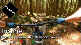
Straight, wide, rocky and fast trail connecting the Mushroom Parking lot trail to the
powerlines. Another section continues from the powerlines to the Baden Powell but this
is not the preferred route down.

Local Trail Association

Recent Activity on Trail

Past Week
  • 18 rides
  • 8 miles average
6 Months
  • 302 rides
  • 9 miles avg distance
All
  • 1,770 rides
  • Last: Jun 19, 2026
c1c2c3c4
January
February
March
April
May
June
July
August
September
October
November
December
update trails status or condition

Incline Trail Reports

statusdatedescription
May 22, 2026 @ 7:28am (America/Vancouver)
May 22, 2026
Good as it gets!
May 11, 2026 @ 2:34pm (America/Vancouver)
May 11, 2026
Beware of the creek gap at the bottom of the trial. There is no signage at all (???) leading up to it - two of us damaged our rear wheels,...
Mar 15, 2026 @ 10:01pm (America/Vancouver)
Mar 15, 2026
Feb 21, 2026 @ 9:18am (America/Vancouver)
Feb 21, 2026
Feb 16, 2026 @ 6:36pm (America/Vancouver)
Feb 16, 2026
more »
Status:
on May 22, 2026
Ideal
Avg: 2.66 (58 votes)
Your vote: 0

view (9,764)
close
3D
Trail Conditions
  • Unknown
  • Snow Groomed
  • Snow Packed
  • Snow Covered
  • Snow Cover Partial
  • Freeze/thaw Cycle
  • Icy
  • Prevalent Mud
  • Wet
  • Variable
  • Ideal
  • Dry
  • Very Dry
Trail Flow (Ridden Direction)
Trailforks scans users ridelogs to determine the most popular direction each trail is ridden. A good flowing trail network will have most trails flowing in a single direction according to their intension.
The colour categories are based on what percentage of riders are riding a trail in its intended direction.
  • > 96%
  • > 90%
  • > 80%
  • > 70%
  • > 50%
  • < 50%
  • bi-directional trail
  • no data
Trail Last Ridden
Trailforks scans ridelogs to determine the last time a trail was ridden.
  • < 2 days
  • < 1 week
  • < 2 weeks
  • < 1 month
  • < 6 months
  • > 6 months
Trail Ridden Direction
The intended direction a trail should be ridden.
  • Downhill Only
  • Downhill Primary
  • Both Directions
  • Uphill Primary
  • Uphill Only
  • One Direction
Contribute Details
Colors indicate trail is missing specified detail.
  • Description
  • Photos
  • Description & Photos
  • Videos
Trail Popularity ?
Trailforks scans ridelogs to determine which trails are ridden the most in the last 9 months. Trails are compared with nearby trails in the same city region with a possible 25 colour shades. Think of this as a heatmap, more rides = more kinetic energy = warmer colors.
  • most popular
  • popular
  • less popular
  • not popular
ATV/ORV/OHV Filter
Max Vehicle Width
inches
US Cell Coverage
Legend
cell carrier legend

Radar Time
Activity Recordings
Trailforks uses anonymized public activity data. ?
Activity Recordings
Trailforks uses anonymized public activity data. ?
Personal Heatmap
Activity Types
all / none
Options
2
Date range month
Winter Trails
Warning A routing network for winter maps does not exist. Selecting trails using the winter trails layer has been disabled.
Missing Trails
Most Popular
Least Popular
Trails are colored based on popularity. The more popular a trail is, the more red. Less popular trails trend towards green.
Jump Magnitude Heatmap
Heatmap of where riders jump on trails. Zoom in to see individual jumps, click circles to view jump details.
BC Backroad Status

Service Road Atlas is a free to use, community-driven service for viewing and creating reports on the numerous back-country service roads around B.C. and Alberta.

map legend
Slope Aspect
Direction the slope faces
Flat N NE E SE S SW W NW
Trails Deemphasized
Trails are shown in grey.
disable
Only show trails with no bike usage.
Enable
Suggested Layers
Based on selected activity type

    Save the current map location and zoom level as your default home location whenever this page is loaded.

    Save
        Directions to incline trailhead (49.343000, -122.973710)

        Photos

        73 more »
        2,071 |
        Jan 5, 2015 @ 9:55pm
        Jan 5, 2015
        446 |
        Apr 1, 2014 @ 11:42am
        Apr 1, 2014
        67 |
        May 29, 2025 @ 2:27pm
        May 29, 2025
        144 |
        Apr 24, 2023 @ 3:39pm
        Apr 24, 2023

        Videos

        20 more »
        youtuber Absolutely  Trail With Boostmaster & Stu!
        2:32 | 422 | Dec 24, 2022 , North Vancouver
        youtuber Incline - Mount Seymour - North Vancouver, BC
        3:08 | 228 | May 20, 2024 , North Vancouver
        Seymour Is Sick, Part 4 | MTB
        17:07 | 293 | Aug 29, 2021 , North Vancouver
        Seymour is sick, part 3 | MTB
        16:04 | 191 | Jun 25, 2021 , North Vancouver

        Trail Lists

        Routes with this trail

        5.0 9 miles 2,074 ft 50
        seymour up GSM to INcline/Pingu
        2.0 14 miles 3,453 ft 38 Loop
        A big Seymour lap looping multiple trails into figure 8's that allows you to make some substitutions if...
        8 miles 1,955 ft 51 Loop
        Seymour Classic East Side Technical Tour North Shore Relive Your Ride For other ride suggestions for this...

        11 Reviews & Comments


        We hope you've been enjoying Trailforks!

        Create a FREE account to view trail comments and much more.

        • By canadakaTF Pro Trailforks & contributors
        • #326 - 12,649 views

        Frequently Asked Questions About Incline

        Where is Incline located?
        Incline is located in Mount Seymour, North Vancouver, British Columbia, Canada. It is part of the Mount Seymour trail network. The trailhead is located at coordinates 49.343, -122.97371.
        How hard is Incline?
        Incline is rated as Black Diamond difficulty. The average grade is 19%.
        What is the elevation gain for Incline?
        The trail has 58 m of elevation descent. The elevation ranges from 496 m to 554 m.
        Is Incline a point to point trail?
        Yes, Incline is a point to point trail. The direction is Downhill Only. The trail type is singletrack.

        Hit the Trail

        Open in App

        Get this trail on your phone instantly.
        open trail in app

        Download Trail

        Save to wishlist, Garmin & download.
        save the trail

        Find Related Routes

        Find routes and users activities that include this trail.
        find routes for this trail

        You must enter a description before submitting.