more stats
3.3 miles
Distance
12 ft
Climb
-2,322 ft
Descent
00:19:24
Avg time
-2,310 ft
Altitude change
5,017 ft
Altitude min
7,327 ft
Altitude max
7,327 ft
Altitude start
5,016 ft
Altitude end
-13.2%
Grade
-70.1%
Grade max
7.8%
Grade min
499 ft
Distance climb
3 miles
Distance down
427 ft
Distance flat
00:19:24
Avg time

Infinity Details

  • Activities
    • Mountain Bike
    • E-Bike
  • Riding Area
  • Difficulty Rating
  • Voted Difficulty
    Blue (3 votes)
  • Local Popularity
    70 in Mountain Biking [+]
    • 75 in E-Biking
  • Global Ranking
    #29917 in Mountain Biking [+]
    • #5606 in E-Biking
  • Trail Type
    Singletrack
  • Bike Type
    AM
  • Climb Difficulty
    Blue
  • Physical Rating
    Hard
  • Trail Visibility
    Always easy to follow
  • eBike Allowed
    Yes up to Class 1
  • TTFs on Trail
    Bridge, Rock Garden, Skinny
  • Year Opened
    2016

DIRECTION
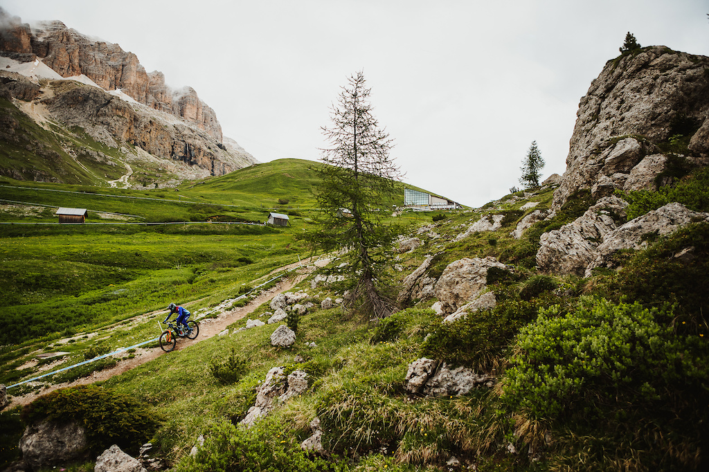
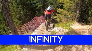
It's the longest line in the Fassa Bike Park: from Passo Pordoi to the town of Canazei.

DESCRIPTION
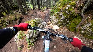
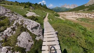
The first kilometer is very fast, but the presence of some technical passages requires caution. After the Hotel Pordoi pond, the trail is rejoined where flow-styled worked parts, with banked turns and drops, alternate with natural sections whose ground is particularly rich in roots.

CAUTION
Rabbe Trail allows bypassing the most technical part of the Infinity trail.

ph NicolaDamonte

Access Info

The trail starts at the Passo Pordoi parking lot.
To reach it, follow the signs:
Gondola Pecol - Col dei Rossi > Fredarola Refuge > Lezuo trail > All Fever trail > Gondola from Pont de Vauz to Passo Pordoi

Trail Supporters

Bike Park

Recent Activity on Trail

Past Week
  • 10 rides
  • 65.8 km average
6 Months
  • 12 rides
  • 65.5 km avg distance
All
  • 280 rides
  • Last: Jun 21, 2026
c1c2c3c4
January
February
March
April
May
June
July
August
September
October
November
December
update trails status or condition

Infinity Trail Reports

Status:
on Jun 21, 2026
Variable
Avg: 3.6 (40 votes)
Your vote: 0

view (1,841)
close
3D
Trail Conditions
  • Unknown
  • Snow Groomed
  • Snow Packed
  • Snow Covered
  • Snow Cover Partial
  • Freeze/thaw Cycle
  • Icy
  • Prevalent Mud
  • Wet
  • Variable
  • Ideal
  • Dry
  • Very Dry
Trail Flow (Ridden Direction)
Trailforks scans users ridelogs to determine the most popular direction each trail is ridden. A good flowing trail network will have most trails flowing in a single direction according to their intension.
The colour categories are based on what percentage of riders are riding a trail in its intended direction.
  • > 96%
  • > 90%
  • > 80%
  • > 70%
  • > 50%
  • < 50%
  • bi-directional trail
  • no data
Trail Last Ridden
Trailforks scans ridelogs to determine the last time a trail was ridden.
  • < 2 days
  • < 1 week
  • < 2 weeks
  • < 1 month
  • < 6 months
  • > 6 months
Trail Ridden Direction
The intended direction a trail should be ridden.
  • Downhill Only
  • Downhill Primary
  • Both Directions
  • Uphill Primary
  • Uphill Only
  • One Direction
Contribute Details
Colors indicate trail is missing specified detail.
  • Description
  • Photos
  • Description & Photos
  • Videos
Trail Popularity ?
Trailforks scans ridelogs to determine which trails are ridden the most in the last 9 months. Trails are compared with nearby trails in the same city region with a possible 25 colour shades. Think of this as a heatmap, more rides = more kinetic energy = warmer colors.
  • most popular
  • popular
  • less popular
  • not popular
ATV/ORV/OHV Filter
Max Vehicle Width
inches
US Cell Coverage
Legend
cell carrier legend

Radar Time
Activity Recordings
Trailforks uses anonymized public activity data. ?
Activity Recordings
Trailforks uses anonymized public activity data. ?
Personal Heatmap
Activity Types
all / none
Options
2
Date range month
Winter Trails
Warning A routing network for winter maps does not exist. Selecting trails using the winter trails layer has been disabled.
Missing Trails
Most Popular
Least Popular
Trails are colored based on popularity. The more popular a trail is, the more red. Less popular trails trend towards green.
Jump Magnitude Heatmap
Heatmap of where riders jump on trails. Zoom in to see individual jumps, click circles to view jump details.
BC Backroad Status

Service Road Atlas is a free to use, community-driven service for viewing and creating reports on the numerous back-country service roads around B.C. and Alberta.

map legend
Slope Aspect
Direction the slope faces
Flat N NE E SE S SW W NW
Trails Deemphasized
Trails are shown in grey.
disable
Only show trails with no bike usage.
Enable
Suggested Layers
Based on selected activity type

    Save the current map location and zoom level as your default home location whenever this page is loaded.

    Save
        Directions to infinity-144453 trailhead (46.487470, 11.810510)

        Photos

        6 more »
        140 |
        Jul 23, 2025 @ 4:00am
        Jul 23, 2025
        220 |
        Aug 17, 2024 @ 8:46pm
        Aug 17, 2024
        451 |
        Mar 19, 2024 @ 1:54am
        Mar 19, 2024
        883 |
        Sep 29, 2019 @ 10:36am
        Sep 29, 2019

        Videos

        14 more »
        youtuber INFINITY & ANIMAL HOUSE  | Bikepark...
        5:51 | 166 | Nov 26, 2025 , Canazei
        youtuber Infinity - Fassa Bike District | Sellaronda...
        9:47 | 539 | Aug 19, 2023 , Canazei
        youtuber MTB Dolomiti Sellaronda 20.09.2023 sentiero...
        11:03 | 419 | Sep 24, 2023 , Canazei
        youtuber MTB Dolomiti Sellaronda 24.09.2022 sentiero...
        15:41 | 561 | Oct 2, 2022 , Canazei

        Routes with this trail

        3.5 37 miles 11,351 ft 6 Loop
        Official Sellaronda MTB Tour - Clockwise direction Choices made: - chosen instead of - fixed official GPX...
        5.0 39 miles 11,488 ft 5 Loop
        Official Sellaronda MTB Tour - Clockwise direction Choices made: - chosen instead of - fixed official GPX...
        4.0 38 miles 12,500 ft 11
        XXXXXXXXXXXXXXXXXXXXXXXXX

        8 Reviews & Comments


        We hope you've been enjoying Trailforks!

        Create a FREE account to view trail comments and much more.

        • By wyllyTF Pro FBD & contributors
        • #144453 - 7,507 views

        Frequently Asked Questions About Infinity

        Where is Infinity located?
        Infinity is located in Fassa Bike District, Canazei, Italy. It is part of the Fassa Bike District trail network. The trailhead is located at coordinates 46.48747, 11.81051.
        How hard is Infinity?
        Infinity is rated as Blue difficulty. The physical rating is Hard. The average grade is 13.2%. The climb difficulty is rated Blue.
        What is the elevation gain for Infinity?
        Infinity has 4 m of elevation gain. The trail has 708 m of elevation descent. The elevation ranges from 1,529 m to 2,233 m.
        How long is Infinity?
        Infinity is 5.3 km long. The trail type is singletrack.

        Hit the Trail

        Open in App

        Get this trail on your phone instantly.
        open trail in app

        Download Trail

        Save to wishlist, Garmin & download.
        save the trail

        Find Related Routes

        Find routes and users activities that include this trail.
        find routes for this trail

        You must enter a description before submitting.