more stats
1.0 mile
Distance
13 ft
Climb
-818 ft
Descent
00:07:49
Avg time
-804 ft
Altitude change
4,606 ft
Altitude min
5,411 ft
Altitude max
5,411 ft
Altitude start
4,606 ft
Altitude end
-14.6%
Grade
-44.7%
Grade max
15.1%
Grade min
240 ft
Distance climb
5,233 ft
Distance down
33 ft
Distance flat
00:07:49
Avg time

International Details

  • Activities
    • Mountain Bike
    • E-Bike
  • Riding Area
  • Difficulty Rating
  • Local Popularity
    85 in Mountain Biking [+]
    • 55 in E-Biking
  • Global Ranking
    #41638 in Mountain Biking [+]
    • #70401 in E-Biking
  • Trail Exposure
    High Risk
  • Trail Type
    Singletrack
  • Bike Type
    DH, AM
  • Direction
    Downhill Only[+]
    Popular Direction Shown
    • Downhill Only for E-Biking
  • Physical Rating
    Extreme
  • Trail Visibility
    Always easy to follow
  • Alpine Trail
    Yes
  • eBike Allowed
    Yes up to Class 1
  • TTFs on Trail
    Berm, Bridge, Drop, Jump, Gap Jump, Rock Garden, Wallride
  • Ride in Rain
    Yes
  • Land Owner
    Alpine Resorts Victoria

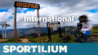
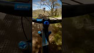
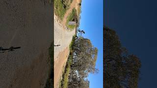
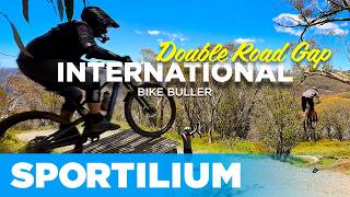
Not for the faint hearted. The most advanced trail at Mt Buller, International is recommended for experts only. Features extremely technical terrain including rock gardens, jumps, berms, bridges and drop-offs.

Bike Park

Traditionally Indigenous Territory

Recent Activity on Trail

Past Week
  • 0 rides
  •  
6 Months
  • 12 rides
  • 20.3 km avg distance
All
  • 29 rides
  • Last: Apr 19, 2026
c1c2c3c4
January
February
March
April
May
June
July
August
September
October
November
December
update trails status or condition

International Trail Reports

statusdatedescription
Apr 24, 2026 @ 11:12am (Australia/Melbourne)
Apr 23, 2026
Closed for the season. See you in November!
Apr 12, 2026 @ 4:24pm (Australia/Melbourne)
Apr 11, 2026
Light dusting of snow
Jan 26, 2026 @ 7:23pm (Australia/Melbourne)
Jan 26, 2026
Open for the summer season
Jan 6, 2026 @ 12:08pm (Australia/Melbourne)
Jan 5, 2026
trail groomed 6th Jan, riding really well. landing area of the 2nd road jump rebuilt on 23rd December after the heavy rain
Dec 21, 2025 @ 10:30am (Australia/Melbourne)
Dec 20, 2025
It’s clear
more »
Status:
on Apr 24, 2026
Variable
Avg: 4.37 (10 votes)
Your vote: 0

view (1,113)
close
3D
Trail Conditions
  • Unknown
  • Snow Groomed
  • Snow Packed
  • Snow Covered
  • Snow Cover Partial
  • Freeze/thaw Cycle
  • Icy
  • Prevalent Mud
  • Wet
  • Variable
  • Ideal
  • Dry
  • Very Dry
Trail Flow (Ridden Direction)
Trailforks scans users ridelogs to determine the most popular direction each trail is ridden. A good flowing trail network will have most trails flowing in a single direction according to their intension.
The colour categories are based on what percentage of riders are riding a trail in its intended direction.
  • > 96%
  • > 90%
  • > 80%
  • > 70%
  • > 50%
  • < 50%
  • bi-directional trail
  • no data
Trail Last Ridden
Trailforks scans ridelogs to determine the last time a trail was ridden.
  • < 2 days
  • < 1 week
  • < 2 weeks
  • < 1 month
  • < 6 months
  • > 6 months
Trail Ridden Direction
The intended direction a trail should be ridden.
  • Downhill Only
  • Downhill Primary
  • Both Directions
  • Uphill Primary
  • Uphill Only
  • One Direction
Contribute Details
Colors indicate trail is missing specified detail.
  • Description
  • Photos
  • Description & Photos
  • Videos
Trail Popularity ?
Trailforks scans ridelogs to determine which trails are ridden the most in the last 9 months. Trails are compared with nearby trails in the same city region with a possible 25 colour shades. Think of this as a heatmap, more rides = more kinetic energy = warmer colors.
  • most popular
  • popular
  • less popular
  • not popular
ATV/ORV/OHV Filter
Max Vehicle Width
inches
US Cell Coverage
Legend
cell carrier legend

Radar Time
Activity Recordings
Trailforks uses anonymized public activity data. ?
Activity Recordings
Trailforks uses anonymized public activity data. ?
Personal Heatmap
Activity Types
all / none
Options
2
Date range month
Winter Trails
Warning A routing network for winter maps does not exist. Selecting trails using the winter trails layer has been disabled.
Missing Trails
Most Popular
Least Popular
Trails are colored based on popularity. The more popular a trail is, the more red. Less popular trails trend towards green.
Jump Magnitude Heatmap
Heatmap of where riders jump on trails. Zoom in to see individual jumps, click circles to view jump details.
BC Backroad Status

Service Road Atlas is a free to use, community-driven service for viewing and creating reports on the numerous back-country service roads around B.C. and Alberta.

map legend
Slope Aspect
Direction the slope faces
Flat N NE E SE S SW W NW
Trails Deemphasized
Trails are shown in grey.
disable
Only show trails with no bike usage.
Enable
Suggested Layers
Based on selected activity type

    Save the current map location and zoom level as your default home location whenever this page is loaded.

    Save
        Directions to international trailhead (-37.142130, 146.440590)

        Photos

        198 more »
        1,165 |
        May 24, 2015 @ 11:29pm
        May 24, 2015
        27,812 |
        Feb 12, 2014 @ 1:17am
        Feb 12, 2014
        249 |
        Dec 4, 2016 @ 12:46pm
        Dec 4, 2016
        197 |
        Jan 29, 2013 @ 12:20am
        Jan 29, 2013

        Videos

        24 more »
        youtuber International – Bike Buller
        5:41 | 548 | Jan 2, 2022 , Mt Buller
        youtuber At 53, I’m tackling two massive road gap...
        0:19 | 91 | Dec 29, 2024 , Mt Buller
        youtuber A Case of Temporary Insanity  #shorts #roadgap...
        0:06 | 109 | Dec 30, 2024 , Mt Buller
        youtuber Double Road Gap Full Send and Full Run on...
        7:35 | 284 | Jan 6, 2025 , Mt Buller

        Routes with this trail

        1 mile 1
        Mountain Bike Nationals - DHI Course

        Trail Products

        Reviews / Comments

        No reviews yet, be the first to write a review or ask a question.
        Use trail reports to comment on trail conditions.


        We hope you've been enjoying Trailforks!

        Create a FREE account to view trail comments and much more.

        • By Cameron-1 & contributors
        • #24770 - 5,839 views

        Frequently Asked Questions About International

        Where is International located?
        International is located in Mt Buller Alpine Resort, Mt Buller, Australia. It is part of the Mt Buller Alpine Resort trail network. The trailhead is located at coordinates -37.14213, 146.44059.
        How hard is International?
        International is rated as Black Diamond difficulty. The physical rating is Extreme. The average grade is 14.6%.
        What is the elevation gain for International?
        International has 4 m of elevation gain. The trail has 249 m of elevation descent. The elevation ranges from 1,404 m to 1,649 m.
        Is International a point to point trail?
        Yes, International is a point to point trail. The direction is Downhill Only. The trail type is singletrack.

        Hit the Trail

        Open in App

        Get this trail on your phone instantly.
        open trail in app

        Download Trail

        Save to wishlist, Garmin & download.
        save the trail

        Find Related Routes

        Find routes and users activities that include this trail.
        find routes for this trail

        You must enter a description before submitting.