more stats
2,402 ft
Distance
-391 ft
Descent
00:03:41
Avg time
-392 ft
Altitude change
1,107 ft
Altitude min
1,499 ft
Altitude max
1,499 ft
Altitude start
1,109 ft
Altitude end
-16.3%
Grade
-38.4%
Grade max
-1.7%
Grade min
2,362 ft
Distance down
00:03:41
Avg time

Irish Death Details

  • Activities
    • Mountain Bike
    • E-Bike
  • Riding Area
    Galbraith
    Bellingham, Washington
  • Difficulty Rating
  • Voted Difficulty
    Black Diamond (7 votes)
  • Local Popularity
    90 in Mountain Biking [+]
    • 85 in E-Biking
  • Global Ranking
    #1613 in Mountain Biking [+]
    • #2198 in E-Biking
  • Trail Type
    Singletrack
  • Bike Type
    DH
  • Physical Rating
    Moderate
  • Dogs Allowed
    Yes
  • eBike Allowed
  • TTFs on Trail
    Bridge, Drop, Jump
  • Ride in Rain
    Yes

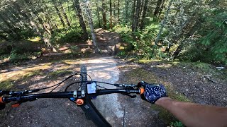
Irish Death is a fantastic trail and the most DH orientated of the ones adjacent to it. It contains many optional root doubles and fun straight lines as you rhythm or smash your way down the trail. There are two optional jumps at the end of the trail, one which features a sniper landing between two trees.

Trail Supporters
Local Trail Association
Traditionally Indigenous Territory

Recent Activity on Trail

Past Week
  • 53 rides
  • 12 miles average
6 Months
  • 278 rides
  • 12 miles avg distance
All
  • 1,990 rides
  • Last: Jun 17, 2026
c1c2c3c4
January
February
March
April
May
June
July
August
September
October
November
December
update trails status or condition

Irish Death Trail Reports

statusdatedescription
Jun 18, 2026 @ 9:53am (America/Los_Angeles)
1 day
reporter Exit and lower portion were brushed prior to WWC 6-18-26
Jun 13, 2026 @ 11:18pm (America/Los_Angeles)
Jun 13, 2026
Jun 4, 2026 @ 1:19pm (America/Los_Angeles)
Jun 4, 2026
reporter Trail inventory rating: 5 Running well - nothing noteworthy needs attention
May 21, 2026 @ 1:03pm (America/Vancouver)
May 21, 2026
Apr 27, 2026 @ 7:58pm (America/Los_Angeles)
Apr 27, 2026
reporter Condition 4. This trail is running great overall with minimal issues and erosion. Lower in the trail before the Stump Jump more and more rocks...
more »
Status:
on Jun 18, 2026
Ideal
Avg: 4.64 (64 votes)
Your vote: 0

view (11,420)
close
3D
Trail Conditions
  • Unknown
  • Snow Groomed
  • Snow Packed
  • Snow Covered
  • Snow Cover Partial
  • Freeze/thaw Cycle
  • Icy
  • Prevalent Mud
  • Wet
  • Variable
  • Ideal
  • Dry
  • Very Dry
Trail Flow (Ridden Direction)
Trailforks scans users ridelogs to determine the most popular direction each trail is ridden. A good flowing trail network will have most trails flowing in a single direction according to their intension.
The colour categories are based on what percentage of riders are riding a trail in its intended direction.
  • > 96%
  • > 90%
  • > 80%
  • > 70%
  • > 50%
  • < 50%
  • bi-directional trail
  • no data
Trail Last Ridden
Trailforks scans ridelogs to determine the last time a trail was ridden.
  • < 2 days
  • < 1 week
  • < 2 weeks
  • < 1 month
  • < 6 months
  • > 6 months
Trail Ridden Direction
The intended direction a trail should be ridden.
  • Downhill Only
  • Downhill Primary
  • Both Directions
  • Uphill Primary
  • Uphill Only
  • One Direction
Contribute Details
Colors indicate trail is missing specified detail.
  • Description
  • Photos
  • Description & Photos
  • Videos
Trail Popularity ?
Trailforks scans ridelogs to determine which trails are ridden the most in the last 9 months. Trails are compared with nearby trails in the same city region with a possible 25 colour shades. Think of this as a heatmap, more rides = more kinetic energy = warmer colors.
  • most popular
  • popular
  • less popular
  • not popular
ATV/ORV/OHV Filter
Max Vehicle Width
inches
US Cell Coverage
Legend
cell carrier legend

Radar Time
Activity Recordings
Trailforks uses anonymized public activity data. ?
Activity Recordings
Trailforks uses anonymized public activity data. ?
Personal Heatmap
Activity Types
all / none
Options
2
Date range month
Winter Trails
Warning A routing network for winter maps does not exist. Selecting trails using the winter trails layer has been disabled.
Missing Trails
Most Popular
Least Popular
Trails are colored based on popularity. The more popular a trail is, the more red. Less popular trails trend towards green.
Jump Magnitude Heatmap
Heatmap of where riders jump on trails. Zoom in to see individual jumps, click circles to view jump details.
BC Backroad Status

Service Road Atlas is a free to use, community-driven service for viewing and creating reports on the numerous back-country service roads around B.C. and Alberta.

map legend
Slope Aspect
Direction the slope faces
Flat N NE E SE S SW W NW
Trails Deemphasized
Trails are shown in grey.
disable
Only show trails with no bike usage.
Enable
Suggested Layers
Based on selected activity type

    Save the current map location and zoom level as your default home location whenever this page is loaded.

    Save
        Directions to irish-death trailhead (48.705230, -122.398790)

        Photos

        38 more »
        3,189 |
        Mar 31, 2017 @ 9:33am
        Mar 31, 2017
        1,140 |
        Mar 31, 2017 @ 9:34am
        Mar 31, 2017
        938 |
        Mar 31, 2017 @ 9:34am
        Mar 31, 2017
        1,003 |
        Apr 29, 2016 @ 10:23pm
        Apr 29, 2016

        Videos

        15 more »
        youtuber Irish Death - Galbraith Mountain (winter)...
        2:49 | 1070 | Jan 20, 2023 , Bellingham
        youtuber Irish Death 2015 - Galbraith Mountain Biking
        2:22 | 775 | Apr 17, 2015 , Bellingham
        Devilcross & Irish Death | Bellingham MTB...
        8:22 | 109 | Sep 26, 2025 , Bellingham
        Irish Death - Bellingham, WA - MTB preview w/...
        0:00 | 188 | Dec 22, 2024 , Bellingham

        Trail Lists

        Routes with this trail

        3.6 83 miles 13,789 ft 474 Loop
        Should be a monster! This route covers every trail on Galbraith at least once. Some uphill trails are...
        4.2 12 miles 2,289 ft 13
        The Cascadia Dirt Cup is proud to once again partner with the NW Tune up to bring the Galbraith Mountain...
        1.0 9 miles 1,554 ft 9
        The Cascadia Dirt Cup is proud to once again partner with the NW Tune up to bring the Galbraith Mountain...

        12 Reviews & Comments


        We hope you've been enjoying Trailforks!

        Create a FREE account to view trail comments and much more.

        • By kyleyoungtransition & contributors
        • #9774 - 16,054 views

        Frequently Asked Questions About Irish Death

        Where is Irish Death located?
        Irish Death is located in Galbraith, Bellingham, Washington, United States. It is part of the Galbraith trail network. The trailhead is located at coordinates 48.70523, -122.39879.
        How hard is Irish Death?
        Irish Death is rated as Black Diamond difficulty. The physical rating is Moderate. The average grade is 16.3%.
        What is the elevation gain for Irish Death?
        The trail has 391 ft of elevation descent. The elevation ranges from 1,107 ft to 1,499 ft.
        How long is Irish Death?
        Irish Death is 2,402 ft long. The trail type is singletrack.

        Hit the Trail

        Open in App

        Get this trail on your phone instantly.
        open trail in app

        Download Trail

        Save to wishlist, Garmin & download.
        save the trail

        Find Related Routes

        Find routes and users activities that include this trail.
        find routes for this trail

        You must enter a description before submitting.