more stats
2.4 miles
Distance
-2,144 ft
Descent
00:22:34
Avg time
-2,143 ft
Altitude change
2,030 ft
Altitude min
4,174 ft
Altitude max
4,174 ft
Altitude start
2,031 ft
Altitude end
-16.8%
Grade
-40.9%
Grade max
3.4%
Grade min
236 ft
Distance climb
2 miles
Distance down
00:22:34
Avg time

Isallo Extasy Details

  • Activities
    • Mountain Bike
    • E-Bike
  • Riding Area
    Finale Outdoor Region
    Finale Ligure
  • Ref Number
    #355
  • Difficulty Rating
  • Voted Difficulty
    Blue (4 votes)
  • Local Popularity
    80 in Mountain Biking [+]
    • 80 in E-Biking
  • Global Ranking
    #138 in Mountain Biking [+]
    • #1057 in E-Biking
  • Trail Type
    Singletrack
  • Bike Type
    AM, XC
  • Climb Difficulty
    Green
  • Physical Rating
    Moderate
  • Trail Visibility
    Sometimes hard to follow
  • Season
    All-year round
  • Dogs Allowed
    Yes
  • eBike Allowed
    Yes up to Class 1
  • Land Owner
    Finale Outdoor Region

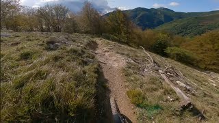
Taking its name from the village it finishes into: Isallo. Exactly where Toboga di Canova ends. This quite technical trail starts from the Barbottina Forest (biggest beech forest in Europe) throughout three different wood types and terrains. After a first kilometer of steep and rooty shoots, it finds its way in the woods in an extremely fast, tight and flowy part filled with wide turns and loam.
A technical rocky section changes the game completely and forces riders to slow down before entering the last exposed and steep bit.

source: ...
Access Info

Exit the E80 highway in Pietra Ligure. Keep going towards the sea and you'll get to Pietra Ligure. You'll then be able to drive toward the mountains in order to reach Val Maremola towns and trails.
Other option would be the E80 exit in Finale Ligure. Keep going towards the sea until you catch the SS1 Via Aurelia and move west until Pietra Ligure.

Disclaimer

Given its nature, the trail can change after weather happenings and season changes. Always pay attention.

Trail Supporters
Local Trail Association

Recent Activity on Trail

Past Week
  • 5 rides
  • 38.3 km average
6 Months
  • 114 rides
  • 42.2 km avg distance
All
  • 621 rides
  • Last: Jun 22, 2026
c1c2c3c4
January
February
March
April
May
June
July
August
September
October
November
December
update trails status or condition

Isallo Extasy Trail Reports

Status:
on Jun 5, 2026
Dry
Avg: 4.58 (74 votes)
Your vote: 0

view (3,506)
close
3D
Trail Conditions
  • Unknown
  • Snow Groomed
  • Snow Packed
  • Snow Covered
  • Snow Cover Partial
  • Freeze/thaw Cycle
  • Icy
  • Prevalent Mud
  • Wet
  • Variable
  • Ideal
  • Dry
  • Very Dry
Trail Flow (Ridden Direction)
Trailforks scans users ridelogs to determine the most popular direction each trail is ridden. A good flowing trail network will have most trails flowing in a single direction according to their intension.
The colour categories are based on what percentage of riders are riding a trail in its intended direction.
  • > 96%
  • > 90%
  • > 80%
  • > 70%
  • > 50%
  • < 50%
  • bi-directional trail
  • no data
Trail Last Ridden
Trailforks scans ridelogs to determine the last time a trail was ridden.
  • < 2 days
  • < 1 week
  • < 2 weeks
  • < 1 month
  • < 6 months
  • > 6 months
Trail Ridden Direction
The intended direction a trail should be ridden.
  • Downhill Only
  • Downhill Primary
  • Both Directions
  • Uphill Primary
  • Uphill Only
  • One Direction
Contribute Details
Colors indicate trail is missing specified detail.
  • Description
  • Photos
  • Description & Photos
  • Videos
Trail Popularity ?
Trailforks scans ridelogs to determine which trails are ridden the most in the last 9 months. Trails are compared with nearby trails in the same city region with a possible 25 colour shades. Think of this as a heatmap, more rides = more kinetic energy = warmer colors.
  • most popular
  • popular
  • less popular
  • not popular
ATV/ORV/OHV Filter
Max Vehicle Width
inches
US Cell Coverage
Legend
cell carrier legend

Radar Time
Activity Recordings
Trailforks uses anonymized public activity data. ?
Activity Recordings
Trailforks uses anonymized public activity data. ?
Personal Heatmap
Activity Types
all / none
Options
2
Date range month
Winter Trails
Warning A routing network for winter maps does not exist. Selecting trails using the winter trails layer has been disabled.
Missing Trails
Most Popular
Least Popular
Trails are colored based on popularity. The more popular a trail is, the more red. Less popular trails trend towards green.
Jump Magnitude Heatmap
Heatmap of where riders jump on trails. Zoom in to see individual jumps, click circles to view jump details.
BC Backroad Status

Service Road Atlas is a free to use, community-driven service for viewing and creating reports on the numerous back-country service roads around B.C. and Alberta.

map legend
Slope Aspect
Direction the slope faces
Flat N NE E SE S SW W NW
Trails Deemphasized
Trails are shown in grey.
disable
Only show trails with no bike usage.
Enable
Suggested Layers
Based on selected activity type

    Save the current map location and zoom level as your default home location whenever this page is loaded.

    Save
        Directions to isallo-extasy trailhead (44.222200, 8.183690)

        Photos

        26 more »
        214 |
        Jan 4, 2024 @ 3:25am
        Jan 4, 2024
        171 |
        Mar 20, 2023 @ 7:53am
        Mar 20, 2023
        218 |
        Jan 7, 2023 @ 9:47am
        Jan 7, 2023
        217 |
        Jan 7, 2023 @ 9:46am
        Jan 7, 2023

        Videos

        13 more »
        youtuber Isallo Exstasy - Finale Ligure | Finale...
        11:03 | 612 | Dec 15, 2023 , Finale Ligure
        youtuber Isallo Extasy Trail // Starts off mellow......
        12:28 | 357 | May 25, 2025 , Finale Ligure
        Finale Ligure eMTBing - Trail Isallo Extasi...
        134 | Jun 22, 2025 , Finale Ligure
        youtuber Isallo Extasy Trail Level Blue Finale Ligure...
        9:21 | 353 | Jan 5, 2025 , Finale Ligure

        Trail Lists

        Routes with this trail

        14 miles 4,752 ft 5
        Isallo then FastFurious from Melogno
        36 miles 9,078 ft 11 Loop Race
        UCI Enduro World Cup Day One Length: 57.78 km +1420m / -61m Stages Stage 1 Isallo Extasy Length: 5.89 km...

        23 Reviews & Comments


        We hope you've been enjoying Trailforks!

        Create a FREE account to view trail comments and much more.

        • By cheorchTF Pro & contributors
        • #46088 - 21,468 views

        Frequently Asked Questions About Isallo Extasy

        Where is Isallo Extasy located?
        Isallo Extasy is located in Finale Outdoor Region, Finale Ligure, Italy. It is part of the Finale Outdoor Region trail network. The trailhead is located at coordinates 44.2222, 8.18369.
        How hard is Isallo Extasy?
        Isallo Extasy is rated as Blue difficulty. The physical rating is Moderate. The average grade is 16.8%. The climb difficulty is rated Green.
        What is the elevation gain for Isallo Extasy?
        The trail has 654 m of elevation descent. The elevation ranges from 619 m to 1,272 m.
        How long is Isallo Extasy?
        Isallo Extasy is 3.9 km long. The trail type is singletrack.

        Hit the Trail

        Open in App

        Get this trail on your phone instantly.
        open trail in app

        Download Trail

        Save to wishlist, Garmin & download.
        save the trail

        Find Related Routes

        Find routes and users activities that include this trail.
        find routes for this trail

        You must enter a description before submitting.