more stats
3.8 miles
Distance
156 ft
Climb
-3,645 ft
Descent
01:46:51
Avg time
-3,489 ft
Altitude change
1,148 ft
Altitude min
4,680 ft
Altitude max
4,637 ft
Altitude start
1,148 ft
Altitude end
-17.4%
Grade
-104.7%
Grade max
39.8%
Grade min
1,430 ft
Distance climb
3 miles
Distance down
276 ft
Distance flat
01:46:51
Avg time

Jack the Ripper Details

  • Activities
    • Mountain Bike
    • E-Bike
    • Hike
    • Trail Running
  • Riding Area
    Mackenzie
    Pemberton, British Columbia
  • Difficulty Rating
  • Voted Difficulty
    Proline (11 votes)
  • Local Popularity
    40 in Mountain Biking [+]
    • 50 in E-Biking
    • 55 in Trail Running
    • 5 in Hiking
  • Global Ranking
    #37511 in Mountain Biking [+]
    • #49231 in E-Biking
    • #50108 in Trail Running
    • #119209 in Hiking
  • Trail Type
    Singletrack
  • Direction
    Downhill Only
    Popular Direction Shown
  • Dogs Allowed
    Yes
  • eBike Allowed
    Yes up to Class 1

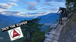
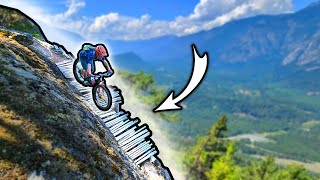
A classic, rowdy Pemberton test piece. Jack The Ripper is named after adventure skier and local Pemberton trail builder Jack Hannan. Who tragically passed away in an avalanche in the Pemberton backcountry.
JTR, has it all, an awesome trail with many challenging cruxes, insane views, surprising sections of flow, all packed into a ride that you'll never forget. It is a big effort just to get to the trailhead and then you need to confidently ride a trail that will pummel you on a bad day and have you grinning from ear to ear on a good day. Keep in mind that JTR is a LONG way from help and ride accordingly. Always proper style points for riding up from the valley on Pemberton's world class climbing trails. If you are up for it and have the skills, what an amazing day out this ride is.

Access Info

Ride up the Nimby climbing network through Middle Earth and continue up from the microwave tower on Xtratron to get to Jack the Ripper

Local Trail Association
Traditionally Indigenous Territory

Recent Activity on Trail

Past Week
  • 1 rides
  • 26.6 km average
6 Months
  • 3 rides
  • 22.0 km avg distance
All
  • 66 rides
  • Last: Jun 16, 2026
c1c2c3c4
January
February
March
April
May
June
July
August
September
October
November
December
update trails status or condition

Jack the Ripper Trail Reports

statusdatedescription
May 16, 2026 @ 6:55pm (America/Vancouver)
May 16, 2026
Small patches of snow on the first part of the trail, but all clear from where the downhill starts.
Jun 14, 2025 @ 7:56pm
Jun 14, 2025
Rode today. No snow, no deadfall. Someone has replaced both wooden bridges. Everything running great. Overgrown in the cut block at the bottom
May 26, 2025 @ 8:23am
May 26, 2025
Still a good amount of snow at the top, deadfall here and there. Very overgrown for the last section, expect being whipped in the face in the last...
Aug 22, 2024 @ 7:39am
Aug 22, 2024
Varios árboles caído, que ya sean retirado y esta limpio.
Aug 21, 2024 @ 10:06am
Aug 21, 2024
more »
Status:
on May 16, 2026
Variable
Avg: 4.28 (40 votes)
Your vote: 0

view (458)
close
3D
Trail Conditions
  • Unknown
  • Snow Groomed
  • Snow Packed
  • Snow Covered
  • Snow Cover Partial
  • Freeze/thaw Cycle
  • Icy
  • Prevalent Mud
  • Wet
  • Variable
  • Ideal
  • Dry
  • Very Dry
Trail Flow (Ridden Direction)
Trailforks scans users ridelogs to determine the most popular direction each trail is ridden. A good flowing trail network will have most trails flowing in a single direction according to their intension.
The colour categories are based on what percentage of riders are riding a trail in its intended direction.
  • > 96%
  • > 90%
  • > 80%
  • > 70%
  • > 50%
  • < 50%
  • bi-directional trail
  • no data
Trail Last Ridden
Trailforks scans ridelogs to determine the last time a trail was ridden.
  • < 2 days
  • < 1 week
  • < 2 weeks
  • < 1 month
  • < 6 months
  • > 6 months
Trail Ridden Direction
The intended direction a trail should be ridden.
  • Downhill Only
  • Downhill Primary
  • Both Directions
  • Uphill Primary
  • Uphill Only
  • One Direction
Contribute Details
Colors indicate trail is missing specified detail.
  • Description
  • Photos
  • Description & Photos
  • Videos
Trail Popularity ?
Trailforks scans ridelogs to determine which trails are ridden the most in the last 9 months. Trails are compared with nearby trails in the same city region with a possible 25 colour shades. Think of this as a heatmap, more rides = more kinetic energy = warmer colors.
  • most popular
  • popular
  • less popular
  • not popular
ATV/ORV/OHV Filter
Max Vehicle Width
inches
US Cell Coverage
Legend
cell carrier legend

Radar Time
Activity Recordings
Trailforks uses anonymized public activity data. ?
Activity Recordings
Trailforks uses anonymized public activity data. ?
Personal Heatmap
Activity Types
all / none
Options
2
Date range month
Winter Trails
Warning A routing network for winter maps does not exist. Selecting trails using the winter trails layer has been disabled.
Missing Trails
Most Popular
Least Popular
Trails are colored based on popularity. The more popular a trail is, the more red. Less popular trails trend towards green.
Jump Magnitude Heatmap
Heatmap of where riders jump on trails. Zoom in to see individual jumps, click circles to view jump details.
BC Backroad Status

Service Road Atlas is a free to use, community-driven service for viewing and creating reports on the numerous back-country service roads around B.C. and Alberta.

map legend
Slope Aspect
Direction the slope faces
Flat N NE E SE S SW W NW
Trails Deemphasized
Trails are shown in grey.
disable
Only show trails with no bike usage.
Enable
Suggested Layers
Based on selected activity type

    Save the current map location and zoom level as your default home location whenever this page is loaded.

    Save
        Directions to jack-the-ripper trailhead (50.364760, -122.778340)

        Photos

        63 more »
        731 |
        Nov 27, 2023 @ 10:52pm
        Nov 27, 2023
        883 |
        Sep 13, 2021 @ 10:06am
        Sep 13, 2021
        1,107 |
        Sep 13, 2021 @ 10:06am
        Sep 13, 2021
        1,104 |
        Jun 22, 2021 @ 12:10pm
        Jun 22, 2021

        Videos

        8 more »
        youtuber JACK THE RIPPER | Pro Line | Pemberton
        25:39 | 454 | Nov 28, 2023 , Pemberton
        youtuber They Warn People Not to Ride This
        26:12 | 1071 | Aug 6, 2023 , Pemberton
        youtuber IS IT REALLY A PRO LINE? - A lap of the...
        35:41 | 5812 | Nov 17, 2017 , Pemberton
        youtuber They Named This Trail After a Serial Killer? ...
        18:01 | 252 | Jan 12, 2025 , Pemberton

        Routes with this trail

        16 miles 4,610 ft 27 Loop
        This day will start off with a very long climb that will likely have you questioning why you embarked on...

        Trail Products

        20 Reviews & Comments


        We hope you've been enjoying Trailforks!

        Create a FREE account to view trail comments and much more.

        Frequently Asked Questions About Jack the Ripper

        Where is Jack the Ripper located?
        Jack the Ripper is located in Mackenzie, Pemberton, British Columbia, Canada. It is part of the Mackenzie trail network. The trailhead is located at coordinates 50.36476, -122.77834.
        How hard is Jack the Ripper?
        Jack the Ripper is rated as Proline difficulty. The average grade is 17.4%.
        What is the elevation gain for Jack the Ripper?
        Jack the Ripper has 156 ft of elevation gain. The trail has 3,645 ft of elevation descent. The elevation ranges from 1,148 ft to 4,680 ft.
        Is Jack the Ripper a point to point trail?
        Yes, Jack the Ripper is a point to point trail. The direction is Downhill Only. The trail type is singletrack.

        Hit the Trail

        Open in App

        Get this trail on your phone instantly.
        open trail in app

        Download Trail

        Save to wishlist, Garmin & download.
        save the trail

        Find Related Routes

        Find routes and users activities that include this trail.
        find routes for this trail

        You must enter a description before submitting.