more stats
1,962 ft
Distance
6 ft
Climb
-253 ft
Descent
00:02:42
Avg time
-247 ft
Altitude change
135 ft
Altitude min
382 ft
Altitude max
382 ft
Altitude start
135 ft
Altitude end
-12.6%
Grade
-24.4%
Grade max
7.2%
Grade min
85 ft
Distance climb
1,739 ft
Distance down
135 ft
Distance flat
00:02:42
Avg time

Jail Brake Details

  • Activities
    • Mountain Bike
    • E-Bike
    • Hike
    • Trail Running
  • Riding Area
    Centennial Reserve
    Wellington
  • AKA
    Jail Break
  • Difficulty Rating
  • Voted Difficulty
    Black Diamond (11 votes)
  • Local Popularity
    70 in Mountain Biking [+]
    • 60 in E-Biking
    • 30 in Trail Running
    • 100 in Hiking
  • Global Ranking
    #862 in Mountain Biking [+]
    • #3534 in E-Biking
    • #90727 in Trail Running
    • #1151 in Hiking
  • Trail Type
    Singletrack
  • Bike Type
    DH, AM, XC
  • Direction
    Downhill Only
    Popular Direction Shown
  • Physical Rating
    Moderate
  • Dogs Allowed
    Yes
  • eBike Allowed
    Yes up to Class 1
  • TTFs on Trail
    Berm, Drop, Jump, Rock Face, Roller Coaster, Wallride
  • Ride in Rain
    Yes
  • Year Opened
    2009
  • Land Owner
    Wellington City Council

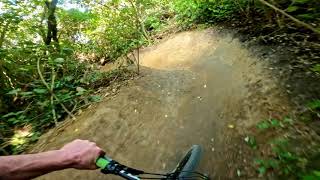
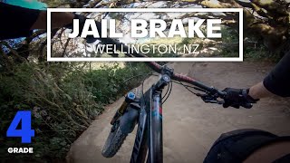
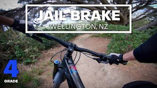
Trail rebuilt (April 2021). Fun downhill trail with large bermed corners. A couple of small drops and one larger one near the bottom are now flowy but all roll-able jumps. Level 3-4 Intermediate when dry, closer to a 4 when wet as the corners are clay and can get greasy (go faster and stay high on the berm). This can be shuttled by car, or you can ride back up Repeat Offender/Conviction/Bootleg to get back to the start.

Access Info

Start from the car park on the right up by the Watertowers on Main Road, Mapuia, Miramar (on the way up to the old prison). Jail Brake starts about 50 metres past the gate, on the left (next to the pump track).

Track is on Wellington City Council reserve land. Public access. Trails are multi use although this track is primarily used by riders, keep and eye out for others. Track is maintained by Miramar Track Project, part of the Wellington Mountain Bike Club.

Trail Supporters
Local Trail Association

Recent Activity on Trail

Past Week
  • 0 rides
  •  
6 Months
  • 24 rides
  • 10 miles avg distance
All
  • 351 rides
  • Last: Jun 12, 2026
c1c2c3c4
January
February
March
April
May
June
July
August
September
October
November
December
Status:
on May 28, 2026
Ideal
Avg: 4.51 (35 votes)
Your vote: 0

view (8,558)
close
3D
Trail Conditions
  • Unknown
  • Snow Groomed
  • Snow Packed
  • Snow Covered
  • Snow Cover Partial
  • Freeze/thaw Cycle
  • Icy
  • Prevalent Mud
  • Wet
  • Variable
  • Ideal
  • Dry
  • Very Dry
Trail Flow (Ridden Direction)
Trailforks scans users ridelogs to determine the most popular direction each trail is ridden. A good flowing trail network will have most trails flowing in a single direction according to their intension.
The colour categories are based on what percentage of riders are riding a trail in its intended direction.
  • > 96%
  • > 90%
  • > 80%
  • > 70%
  • > 50%
  • < 50%
  • bi-directional trail
  • no data
Trail Last Ridden
Trailforks scans ridelogs to determine the last time a trail was ridden.
  • < 2 days
  • < 1 week
  • < 2 weeks
  • < 1 month
  • < 6 months
  • > 6 months
Trail Ridden Direction
The intended direction a trail should be ridden.
  • Downhill Only
  • Downhill Primary
  • Both Directions
  • Uphill Primary
  • Uphill Only
  • One Direction
Contribute Details
Colors indicate trail is missing specified detail.
  • Description
  • Photos
  • Description & Photos
  • Videos
Trail Popularity ?
Trailforks scans ridelogs to determine which trails are ridden the most in the last 9 months. Trails are compared with nearby trails in the same city region with a possible 25 colour shades. Think of this as a heatmap, more rides = more kinetic energy = warmer colors.
  • most popular
  • popular
  • less popular
  • not popular
ATV/ORV/OHV Filter
Max Vehicle Width
inches
US Cell Coverage
Legend
cell carrier legend

Radar Time
Activity Recordings
Trailforks uses anonymized public activity data. ?
Activity Recordings
Trailforks uses anonymized public activity data. ?
Personal Heatmap
Activity Types
all / none
Options
2
Date range month
Winter Trails
Warning A routing network for winter maps does not exist. Selecting trails using the winter trails layer has been disabled.
Missing Trails
Most Popular
Least Popular
Trails are colored based on popularity. The more popular a trail is, the more red. Less popular trails trend towards green.
Jump Magnitude Heatmap
Heatmap of where riders jump on trails. Zoom in to see individual jumps, click circles to view jump details.
BC Backroad Status

Service Road Atlas is a free to use, community-driven service for viewing and creating reports on the numerous back-country service roads around B.C. and Alberta.

map legend
Slope Aspect
Direction the slope faces
Flat N NE E SE S SW W NW
Trails Deemphasized
Trails are shown in grey.
disable
Only show trails with no bike usage.
Enable
Suggested Layers
Based on selected activity type

    Save the current map location and zoom level as your default home location whenever this page is loaded.

    Save
        Directions to jail-brake trailhead (-41.298880, 174.824490)

        Photos

        15 more »
        333 |
        Mar 17, 2019 @ 12:38am
        Mar 17, 2019
        154 |
        Mar 17, 2019 @ 12:46am
        Mar 17, 2019
        155 |
        Mar 17, 2019 @ 12:42am
        Mar 17, 2019
        194 |
        Feb 12, 2019 @ 12:11am
        Feb 12, 2019

        Videos

        23 more »
        youtuber Jail Brake(REBUILT!!!) @ Centennial...
        2:10 | 793 | Apr 27, 2021 , Wellington
        youtuber NEW JUMPS & FLOW - Jail Brake (Rebuild)...
        2:12 | 728 | Apr 26, 2021 , Wellington
        youtuber FUN FLOW - Jail Brake Mountain Bike Trail...
        2:25 | 564 | Sep 26, 2020 , Wellington
        youtuber Jail Break on to Repeat Offender @ Miramar
        4:09 | 616 | Jul 6, 2018 , Wellington

        11 Reviews & Comments


        We hope you've been enjoying Trailforks!

        Create a FREE account to view trail comments and much more.

        • By jhc123 & contributors
        • #17127 - 10,883 views

        Frequently Asked Questions About Jail Brake

        Where is Jail Brake located?
        Jail Brake is located in Centennial Reserve, Wellington, New Zealand. It is part of the Centennial Reserve trail network. The trailhead is located at coordinates -41.29888, 174.82449.
        How hard is Jail Brake?
        Jail Brake is rated as Advanced difficulty. The physical rating is Moderate. The average grade is 12.6%.
        What is the elevation gain for Jail Brake?
        Jail Brake has 6 ft of elevation gain. The trail has 253 ft of elevation descent. The elevation ranges from 135 ft to 382 ft.
        Is Jail Brake a point to point trail?
        Yes, Jail Brake is a point to point trail. The direction is Downhill Only. The trail type is singletrack.

        Hit the Trail

        Open in App

        Get this trail on your phone instantly.
        open trail in app

        Download Trail

        Save to wishlist, Garmin & download.
        save the trail

        Find Related Routes

        Find routes and users activities that include this trail.
        find routes for this trail

        You must enter a description before submitting.