more stats
4,419 ft
Distance
15 ft
Climb
-487 ft
Descent
00:03:50
Avg time
-472 ft
Altitude change
1,035 ft
Altitude min
1,507 ft
Altitude max
1,507 ft
Altitude start
1,033 ft
Altitude end
-10.7%
Grade
-59.8%
Grade max
6.3%
Grade min
325 ft
Distance climb
3,986 ft
Distance down
105 ft
Distance flat
00:03:50
Avg time

Jedi Jumps Details

  • Activities
    • Mountain Bike
    • E-Bike
  • Riding Area
    Will Rogers State Park
    Santa Monica, California
  • AKA
    Jedi plunge
  • Difficulty Rating
  • Voted Difficulty
    Black Diamond (12 votes)
  • Local Popularity
    95 in Mountain Biking [+]
    • 100 in E-Biking
  • Global Ranking
    #23277 in Mountain Biking [+]
    • #1903 in E-Biking
  • Trail Type
    Singletrack
  • Bike Type
    DH, AM, XC, DJ
  • Direction
    Downhill Only
    Popular Direction Shown
  • Climb Difficulty
    Double Black Diamond
  • Physical Rating
    Hard
  • eBike Allowed
    Yes up to Class 1
  • TTFs on Trail
    Berm, Jump, Gap Jump, Roller Coaster

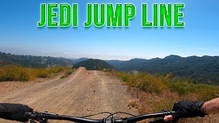
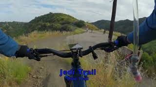
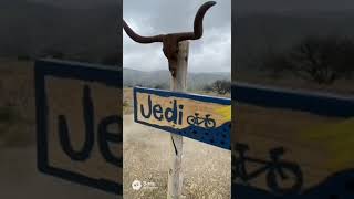
Downhill only trail (with all the predominate downhill traffic please do not risk climbing this). This trail consists of loose shale and gravel with long parallel ruts, a few berms and jumps. Ridden at high speed due to the steepness and wide open sight lines, requires high level bike handling skills and fitness as there are some steep short punchy climbs to connect and flow the trail together. Warrning: hikers occasionally climb this trail from the bottom representing a real hazard coming over the top of the large hills where sight lines are minimal. Use caution especially on weekends and holidays as those are the hikers that are unfamiliar with the terrain and the general use of this trail.

This trail is unsanctioned.

Disclaimer

Please pay attention to anyone appearing to do trail work as an unidentified individual has been destroying the trail.

Traditionally Indigenous Territory

Recent Activity on Trail

Past Week
  • 6 rides
  • 26.6 km average
6 Months
  • 117 rides
  • 24.7 km avg distance
All
  • 1,042 rides
  • Last: Jun 19, 2026
c1c2c3c4
January
February
March
April
May
June
July
August
September
October
November
December
update trails status or condition

Jedi Jumps Trail Reports

statusdatedescription
Jun 14, 2026 @ 9:36am (America/Los_Angeles)
Jun 14, 2026
Jun 5, 2026 @ 9:10am (America/Los_Angeles)
Jun 5, 2026
Don't forget to hit "side burns" it's never been faster or smoother than now. Big Thank you to whoever is working on this and Nicholas Cage! ...
Jun 5, 2026 @ 6:50am (America/Los_Angeles)
Jun 5, 2026
May 30, 2026 @ 11:36am (America/Los_Angeles)
May 30, 2026
New tree jump line is sick, thanks trail team
May 30, 2026 @ 11:10am (America/Los_Angeles)
May 30, 2026
Couple of loose dirt/gravel and berms are blow out
more »
Status:
on Jun 14, 2026
Dry
Avg: 4.31 (26 votes)
Your vote: 0

view (10,585)
close
3D
Trail Conditions
  • Unknown
  • Snow Groomed
  • Snow Packed
  • Snow Covered
  • Snow Cover Partial
  • Freeze/thaw Cycle
  • Icy
  • Prevalent Mud
  • Wet
  • Variable
  • Ideal
  • Dry
  • Very Dry
Trail Flow (Ridden Direction)
Trailforks scans users ridelogs to determine the most popular direction each trail is ridden. A good flowing trail network will have most trails flowing in a single direction according to their intension.
The colour categories are based on what percentage of riders are riding a trail in its intended direction.
  • > 96%
  • > 90%
  • > 80%
  • > 70%
  • > 50%
  • < 50%
  • bi-directional trail
  • no data
Trail Last Ridden
Trailforks scans ridelogs to determine the last time a trail was ridden.
  • < 2 days
  • < 1 week
  • < 2 weeks
  • < 1 month
  • < 6 months
  • > 6 months
Trail Ridden Direction
The intended direction a trail should be ridden.
  • Downhill Only
  • Downhill Primary
  • Both Directions
  • Uphill Primary
  • Uphill Only
  • One Direction
Contribute Details
Colors indicate trail is missing specified detail.
  • Description
  • Photos
  • Description & Photos
  • Videos
Trail Popularity ?
Trailforks scans ridelogs to determine which trails are ridden the most in the last 9 months. Trails are compared with nearby trails in the same city region with a possible 25 colour shades. Think of this as a heatmap, more rides = more kinetic energy = warmer colors.
  • most popular
  • popular
  • less popular
  • not popular
ATV/ORV/OHV Filter
Max Vehicle Width
inches
US Cell Coverage
Legend
cell carrier legend

Radar Time
Activity Recordings
Trailforks uses anonymized public activity data. ?
Activity Recordings
Trailforks uses anonymized public activity data. ?
Personal Heatmap
Activity Types
all / none
Options
2
Date range month
Winter Trails
Warning A routing network for winter maps does not exist. Selecting trails using the winter trails layer has been disabled.
Missing Trails
Most Popular
Least Popular
Trails are colored based on popularity. The more popular a trail is, the more red. Less popular trails trend towards green.
Jump Magnitude Heatmap
Heatmap of where riders jump on trails. Zoom in to see individual jumps, click circles to view jump details.
BC Backroad Status

Service Road Atlas is a free to use, community-driven service for viewing and creating reports on the numerous back-country service roads around B.C. and Alberta.

map legend
Slope Aspect
Direction the slope faces
Flat N NE E SE S SW W NW
Trails Deemphasized
Trails are shown in grey.
disable
Only show trails with no bike usage.
Enable
Suggested Layers
Based on selected activity type

    Save the current map location and zoom level as your default home location whenever this page is loaded.

    Save
        Directions to jedi-jumps trailhead (34.093620, -118.523970)

        Photos

        25 more »
        102 |
        May 28, 2025 @ 6:24pm
        May 28, 2025
        99 |
        May 19, 2025 @ 9:13pm
        May 19, 2025
        464 |
        Apr 26, 2021 @ 5:00pm
        Apr 26, 2021
        462 |
        Apr 25, 2021 @ 7:56pm
        Apr 25, 2021

        Videos

        24 more »
        youtuber Jedi Jump Line - Mountain Biking - Will Rogers...
        5:38 | 711 | Apr 29, 2023 , Santa Monica
        youtuber Jedi Jumpline - Mountain Biking -...
        3:03 | 521 | Aug 28, 2022 , Santa Monica
        Mountain Biking Jedi and Nicholas Cage Trail...
        13:23 | 36 | Apr 4, 2026 , Santa Monica
        Sullivan Ridge trail. Totally not AI
        0:10 | 59 | Nov 24, 2025 , Santa Monica

        Routes with this trail

        5.0 21 miles 4,378 ft 14 Loop
        A lot of the really fun enduro trails in the Santa Monica Mountains. The classics, and panic as that is a...
        3.0 13 miles 2,805 ft 19 Loop
        This is a loop of the most popular/fun enduro trails in Santa Monica. A 130-170mm bike would be ideal for...
        11 miles 1,847 ft 8 Loop
        Sullivan Canyon Trailhead to Westridge Loop

        18 Reviews & Comments


        We hope you've been enjoying Trailforks!

        Create a FREE account to view trail comments and much more.

        • #68917 - 17,472 views

        Frequently Asked Questions About Jedi Jumps

        Where is Jedi Jumps located?
        Jedi Jumps is located in Will Rogers State Park, Santa Monica, California, United States. It is part of the Will Rogers State Park trail network. The trailhead is located at coordinates 34.09362, -118.52397.
        How hard is Jedi Jumps?
        Jedi Jumps is rated as Blue difficulty. The physical rating is Hard. The average grade is 10.7%. The climb difficulty is rated Double Black Diamond.
        What is the elevation gain for Jedi Jumps?
        Jedi Jumps has 15 ft of elevation gain. The trail has 487 ft of elevation descent. The elevation ranges from 1,035 ft to 1,507 ft.
        Is Jedi Jumps a point to point trail?
        Yes, Jedi Jumps is a point to point trail. The direction is Downhill Only. The trail type is singletrack.

        Hit the Trail

        Open in App

        Get this trail on your phone instantly.
        open trail in app

        Download Trail

        Save to wishlist, Garmin & download.
        save the trail

        Find Related Routes

        Find routes and users activities that include this trail.
        find routes for this trail

        You must enter a description before submitting.