more stats
4.0 miles
Distance
67 ft
Climb
-517 ft
Descent
00:17:48
Avg time
-450 ft
Altitude change
3,561 ft
Altitude min
4,012 ft
Altitude max
4,012 ft
Altitude start
3,563 ft
Altitude end
-2.2%
Grade
-25%
Grade max
16.7%
Grade min
2,582 ft
Distance climb
3 miles
Distance down
1,362 ft
Distance flat
00:17:48
Avg time

Jem Details

  • Activities
    • Mountain Bike
    • Gravel Bike
    • Adaptive Bike
    • Winter Fat Bike
    • Hike
    • Trail Running
  • Riding Area
    Hurricane Cliffs
    Hurricane, Utah
  • Difficulty Rating
  • Voted Difficulty
    Green (4 votes)
  • Local Popularity
    90 in Mountain Biking [+]
    • 5 in Trail Running
    • 70 in Hiking
  • Global Ranking
    #1737 in Mountain Biking [+]
    • #93107 in Trail Running
    • #1325 in Hiking
  • Trail Type
    Singletrack
  • Bike Type
    AM, XC, Fat, Adaptive MTB, Gravel
  • Direction
    Both Directions
    Popular Direction Shown
  • Climb Difficulty
    Green
  • Physical Rating
    Moderate
  • Dogs Allowed
    Yes
  • eBike Allowed
  • TTFs on Trail
    Drop, Rock Garden
  • Land Owner
    Bureau of Land Management

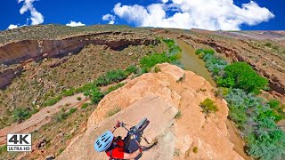
This section of the JEM trail is amazing. The whole ride down is full of fast flowing turns. There are a couple of technical sections but nothing to stress about. Definitely worth the short climb... and definitely worth doing more than one lap

Adaptive Bike Info
aMTB Blue Rating: Intermediate features and steeper terrain.

Trail width 24-48 inches. Camber is mostly on. No exposure. A couple of very doable downhill tech sections with drops. Not recommended for a climb.

Fast and fun. The jewel of adaptive biking here.

Trail Supporters
  • BLM
    BLM
    Land Manager
Local Trail Association
Traditionally Indigenous Territory

Recent Activity on Trail

Past Week
  • 0 rides
  •  
6 Months
  • 90 rides
  • 18 miles avg distance
All
  • 1,011 rides
  • Last: Jun 19, 2026
c1c2c3c4
January
February
March
April
May
June
July
August
September
October
November
December
update trails status or condition

Jem Trail Reports

statusdatedescription
Mar 13, 2026 @ 2:50pm (America/Denver)
Mar 13, 2026
Great shape!
Jan 18, 2026 @ 11:24pm (America/Denver)
Jan 18, 2026
Lots of soft and muddy sections this morning. Lots of dry perfect sections too, but the further south and towards Gooseberry Mesa the more muddy...
Oct 17, 2025 @ 2:13pm (America/Denver)
Oct 17, 2025
Sep 3, 2025 @ 6:44am
Sep 3, 2025
Mar 21, 2025 @ 9:47am
Mar 21, 2025
Fast and fun. Nice to have the small drops and jumps on occasion.
more »
Status:
on Mar 13, 2026
Dry
Avg: 3.88 (62 votes)
Your vote: 0

view (6,676)
close
3D
Trail Conditions
  • Unknown
  • Snow Groomed
  • Snow Packed
  • Snow Covered
  • Snow Cover Partial
  • Freeze/thaw Cycle
  • Icy
  • Prevalent Mud
  • Wet
  • Variable
  • Ideal
  • Dry
  • Very Dry
Trail Flow (Ridden Direction)
Trailforks scans users ridelogs to determine the most popular direction each trail is ridden. A good flowing trail network will have most trails flowing in a single direction according to their intension.
The colour categories are based on what percentage of riders are riding a trail in its intended direction.
  • > 96%
  • > 90%
  • > 80%
  • > 70%
  • > 50%
  • < 50%
  • bi-directional trail
  • no data
Trail Last Ridden
Trailforks scans ridelogs to determine the last time a trail was ridden.
  • < 2 days
  • < 1 week
  • < 2 weeks
  • < 1 month
  • < 6 months
  • > 6 months
Trail Ridden Direction
The intended direction a trail should be ridden.
  • Downhill Only
  • Downhill Primary
  • Both Directions
  • Uphill Primary
  • Uphill Only
  • One Direction
Contribute Details
Colors indicate trail is missing specified detail.
  • Description
  • Photos
  • Description & Photos
  • Videos
Trail Popularity ?
Trailforks scans ridelogs to determine which trails are ridden the most in the last 9 months. Trails are compared with nearby trails in the same city region with a possible 25 colour shades. Think of this as a heatmap, more rides = more kinetic energy = warmer colors.
  • most popular
  • popular
  • less popular
  • not popular
ATV/ORV/OHV Filter
Max Vehicle Width
inches
US Cell Coverage
Legend
cell carrier legend

Radar Time
Activity Recordings
Trailforks uses anonymized public activity data. ?
Activity Recordings
Trailforks uses anonymized public activity data. ?
Personal Heatmap
Activity Types
all / none
Options
2
Date range month
Winter Trails
Warning A routing network for winter maps does not exist. Selecting trails using the winter trails layer has been disabled.
Missing Trails
Most Popular
Least Popular
Trails are colored based on popularity. The more popular a trail is, the more red. Less popular trails trend towards green.
Jump Magnitude Heatmap
Heatmap of where riders jump on trails. Zoom in to see individual jumps, click circles to view jump details.
BC Backroad Status

Service Road Atlas is a free to use, community-driven service for viewing and creating reports on the numerous back-country service roads around B.C. and Alberta.

map legend
Slope Aspect
Direction the slope faces
Flat N NE E SE S SW W NW
Trails Deemphasized
Trails are shown in grey.
disable
Only show trails with no bike usage.
Enable
Suggested Layers
Based on selected activity type

    Save the current map location and zoom level as your default home location whenever this page is loaded.

    Save
        Directions to jem-9285 trailhead (37.151820, -113.251850)

        Photos

        66 more »
        31 |
        Apr 21, 2026 @ 2:09pm
        Apr 21, 2026
        68 |
        Sep 5, 2025 @ 2:39pm
        Sep 5, 2025
        96 |
        Oct 13, 2022 @ 3:45pm
        Oct 13, 2022
        168 |
        Aug 7, 2022 @ 12:33pm
        Aug 7, 2022

        Videos

        9 more »
        youtuber Spectacular MTB Bike Trail | JEM Trail |...
        8:08 | 693 | Jul 2, 2023 , Hurricane
        JEM Trail | The Best Flow Trail in Utah
        7:33 | 114 | Nov 10, 2025 , Hurricane
        JEM Mountain Bike Trail | Hurricane, UT
        3:56 | 744 | Oct 24, 2021 , Hurricane
        JEM trail, Hurricane Utah
        9:21 | 695 | Apr 23, 2021 , Hurricane

        Routes with this trail

        5.0 8 miles 591 ft 5 Loop
        This is the 2017 Intermountain Cup Cactus Hugger Race route for one lap.
        5.0 16 miles 1,322 ft 20
        This is our planned medium length (~13 miles) loop in the Hurricane cliffs area. Hitting all of with an...
        8 miles 630 ft 2
        https://www.redrockbicycle.com/articles/cactus-hugger-pg1352.htm The race will utilize much of the well...

        22 Reviews & Comments


        We hope you've been enjoying Trailforks!

        Create a FREE account to view trail comments and much more.

        • By toddTF Pro Trailforks & contributors
        • #9285 - 19,775 views

        Frequently Asked Questions About Jem

        Where is Jem located?
        Jem is located in Hurricane Cliffs, Hurricane, Utah, United States. It is part of the Hurricane Cliffs trail network. The trailhead is located at coordinates 37.15182, -113.25185.
        How hard is Jem?
        Jem is rated as Green difficulty. The physical rating is Moderate. The average grade is 2.2%. The climb difficulty is rated Green.
        What is the elevation gain for Jem?
        Jem has 67 ft of elevation gain. The trail has 517 ft of elevation descent. The elevation ranges from 3,561 ft to 4,012 ft.
        Is Jem a point to point trail?
        Jem is not a point to point trail. The direction is Both Directions. The trail type is singletrack.

        Hit the Trail

        Open in App

        Get this trail on your phone instantly.
        open trail in app

        Download Trail

        Save to wishlist, Garmin & download.
        save the trail

        Find Related Routes

        Find routes and users activities that include this trail.
        find routes for this trail

        You must enter a description before submitting.