This trail is permanently closed/decommissioned
more stats
2,705 ft
Distance
-606 ft
Descent
00:06:30
Avg time
-606 ft
Altitude change
1,584 ft
Altitude min
2,189 ft
Altitude max
2,189 ft
Altitude start
1,584 ft
Altitude end
-22.386%
Grade
-32.901%
Grade max
-8.45%
Grade min
2,684 ft
Distance down
21 ft
Distance flat
00:06:30
Avg time

Jerry Rig Details

  • Activities
    • Mountain Bike
    • E-Bike
    • Hike
    • Trail Running
  • Riding Area
    Mount Fromme
    North Vancouver, British Columbia
  • Difficulty Rating
  • Voted Difficulty
    Proline (1 vote)
  • Local Popularity
    60 in Mountain Biking [+]
    • 45 in E-Biking
    • 30 in Trail Running
    • 20 in Hiking
  • Trail Type
    Singletrack
  • Bike Type
    DH
  • Direction
    Downhill Primary
    Popular Direction Shown
  • Dogs Allowed
    Yes
  • eBike Allowed
  • TTFs on Trail
    Jump, Skinny, Wallride

Exceptionally challenging trail with mandatory jumps, skinnys and other TTFs.

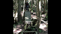
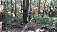
This is the hardest trail on the shore for riding stunts. Pros only. The rig starts with the coolest log I've ever ridden--a rounded one that curves down for 30 feet with the highest point 10 feet above ground. This takes you into some skinnies that side loft you to a transition to bermed air, to a huge wooden wall ride. From there the trail is mayhem: blind 17 foot gapped step downs over stumps, downhill 4 inch wide log rides with airs on the end, a 130 foot 5 inch wide log ride to 8 foot drop over a 6 foot gap, a launch to a step down 12 foot gap, a bunch of wooden and dirt jumps with a load of log and ladder bridge riding. Best to ride it with someone who has done the trail before; do it on a bone-dry day wearing as much armour as possible.

Access Info

Access of Mountain Hwy, ends at the bottom of Air Supply.

This trail is unsanctioned.

Recent Activity on Trail

Past Week
  • 7 rides
  • 8 miles average
6 Months
  • 30 rides
  • 8 miles avg distance
All
  • 227 rides
  • Last: Jun 17, 2026
c1c2c3c4
January
February
March
April
May
June
July
August
September
October
November
December
update trails status or condition

Jerry Rig Trail Reports

Status:
on Apr 20, 2025
Avg: 4.07 (7 votes)
Your vote: 0

view (945)
close
3D
Trail Conditions
  • Unknown
  • Snow Groomed
  • Snow Packed
  • Snow Covered
  • Snow Cover Partial
  • Freeze/thaw Cycle
  • Icy
  • Prevalent Mud
  • Wet
  • Variable
  • Ideal
  • Dry
  • Very Dry
Trail Flow (Ridden Direction)
Trailforks scans users ridelogs to determine the most popular direction each trail is ridden. A good flowing trail network will have most trails flowing in a single direction according to their intension.
The colour categories are based on what percentage of riders are riding a trail in its intended direction.
  • > 96%
  • > 90%
  • > 80%
  • > 70%
  • > 50%
  • < 50%
  • bi-directional trail
  • no data
Trail Last Ridden
Trailforks scans ridelogs to determine the last time a trail was ridden.
  • < 2 days
  • < 1 week
  • < 2 weeks
  • < 1 month
  • < 6 months
  • > 6 months
Trail Ridden Direction
The intended direction a trail should be ridden.
  • Downhill Only
  • Downhill Primary
  • Both Directions
  • Uphill Primary
  • Uphill Only
  • One Direction
Contribute Details
Colors indicate trail is missing specified detail.
  • Description
  • Photos
  • Description & Photos
  • Videos
Trail Popularity ?
Trailforks scans ridelogs to determine which trails are ridden the most in the last 9 months. Trails are compared with nearby trails in the same city region with a possible 25 colour shades. Think of this as a heatmap, more rides = more kinetic energy = warmer colors.
  • most popular
  • popular
  • less popular
  • not popular
ATV/ORV/OHV Filter
Max Vehicle Width
inches
US Cell Coverage
Legend
cell carrier legend

Radar Time
Activity Recordings
Trailforks uses anonymized public activity data. ?
Activity Recordings
Trailforks uses anonymized public activity data. ?
Personal Heatmap
Activity Types
all / none
Options
2
Date range month
Winter Trails
Warning A routing network for winter maps does not exist. Selecting trails using the winter trails layer has been disabled.
Missing Trails
Most Popular
Least Popular
Trails are colored based on popularity. The more popular a trail is, the more red. Less popular trails trend towards green.
Jump Magnitude Heatmap
Heatmap of where riders jump on trails. Zoom in to see individual jumps, click circles to view jump details.
BC Backroad Status

Service Road Atlas is a free to use, community-driven service for viewing and creating reports on the numerous back-country service roads around B.C. and Alberta.

map legend
Slope Aspect
Direction the slope faces
Flat N NE E SE S SW W NW
Trails Deemphasized
Trails are shown in grey.
disable
Only show trails with no bike usage.
Enable
Suggested Layers
Based on selected activity type

    Save the current map location and zoom level as your default home location whenever this page is loaded.

    Save
        Directions to jerry-rig trailhead (49.358240, -123.060410)

        Photos

        103 more »
        114 |
        Nov 29, 2025 @ 10:13am
        Nov 29, 2025
        115 |
        Jun 6, 2024 @ 10:06am
        Jun 6, 2024
        102 |
        Jun 6, 2024 @ 10:06am
        Jun 6, 2024
        126 |
        Jun 6, 2024 @ 10:06am
        Jun 6, 2024

        Videos

        4 more »
        Riding what’s left of jerry rig // MT.Fromme
        0:59 | 1366 | Oct 11, 2020 , North Vancouver
        Jerry Rig 2007
        3616 | Sep 19, 2011 , North Vancouver
        Jerry riggin’
        0:23 | 605 | Jul 15, 2020 , North Vancouver
        Gnarly North Shore
        0:04 | 8145 | Sep 4, 2018 , North Vancouver

        3 Reviews & Comments


        We hope you've been enjoying Trailforks!

        Create a FREE account to view trail comments and much more.

        • #155 - 13,993 views

        Frequently Asked Questions About Jerry Rig

        Where is Jerry Rig located?
        Jerry Rig is located in Mount Fromme, North Vancouver, British Columbia, Canada. It is part of the Mount Fromme trail network. The trailhead is located at coordinates 49.35824, -123.06041.
        How hard is Jerry Rig?
        Jerry Rig is rated as Double Black Diamond difficulty. The average grade is 22.386%.
        What is the elevation gain for Jerry Rig?
        The trail has 606 ft of elevation descent. The elevation ranges from 1,584 ft to 2,189 ft.
        Is Jerry Rig a point to point trail?
        Jerry Rig is not a point to point trail. The direction is Downhill Primary. The trail type is singletrack.

        Hit the Trail

        Open in App

        Get this trail on your phone instantly.
        open trail in app

        Download Trail

        Save to wishlist, Garmin & download.
        save the trail

        Find Related Routes

        Find routes and users activities that include this trail.
        find routes for this trail

        You must enter a description before submitting.