
Open in App
Get this trail on your phone instantly.

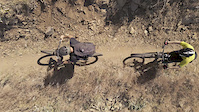
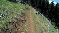
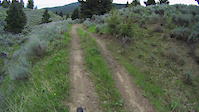
This trail was cut during the summer of 2016 and has since become popular for beginner to intermediate riders. It is also well known and travelled in the Springtime as it is one of the first Gallatin Valley trails to melt out. It starts at the Johnson Canyon trailhead and gains altitude at a nice mellow rate. The trail is a comfortable width (~3ft) and is mostly free of rocks and roots. As you continue to climb up towards the top, scenic views will present themselves for brief moments before the trail disappears back into the forest. This is a great trail for beginner to intermediate riders looking for a fun but still challenging trail. Be sure to check your speed in the switchbacks, as well as some of the curved sections that weave through trees right off the trail. These sections are either flat with no berm/bank or are off-chamber and will want to pull your wheels off the trail. It is a steady climb from the trailhead and gains about 1,300 feet over 4.5 miles. It is recommended to stop and turn around at 4.5 miles unless you are willing to climb back up the following downhill, which is much steeper than the initial climb. If choose to venture beyond 4.5 mile marker you are greeted with very fast, exposed, steep descent into North Cottonwood canyon. Once you hit the bridge at the bottom of the descent into North Cottonwood you will need to turn around and head back from the way you came.
From the Johnson Canyon parking head uphill at the Northeast end of the lot and you will find the trail sign to the left before the seasonal closure gate on the Johnson Canyon motorized use road.
Please be aware of creek crossings in Spring runoff
| c1 | c2 | c3 | c4 |
|---|---|---|---|
January | February | March | April |
May | June | July | August |
September | October | November | December |

Service Road Atlas is a free to use, community-driven service for viewing and creating reports on the numerous back-country service roads around B.C. and Alberta.
Save the current map location and zoom level as your default home location whenever this page is loaded.
SaveWe hope you've been enjoying Trailforks!
Create a FREE account to view trail comments and much more.
You must enter a description before submitting.

