more stats
1.4 miles
Distance
79 ft
Climb
-621 ft
Descent
00:08:46
Avg time
-542 ft
Altitude change
2,615 ft
Altitude min
3,161 ft
Altitude max
3,161 ft
Altitude start
2,618 ft
Altitude end
-7.372%
Grade
-28.687%
Grade max
36.535%
Grade min
842 ft
Distance climb
1 mile
Distance down
556 ft
Distance flat
00:08:46
Avg time

JP Cool Details

  • Activities
    • Mountain Bike
    • E-Bike
    • Hike
    • Trail Running
  • Riding Area
    Coutlee Plateau
    Merritt, British Columbia
  • Difficulty Rating
  • Local Popularity
    90 in Mountain Biking [+]
    • 90 in E-Biking
    • 95 in Trail Running
    • 70 in Hiking
  • Global Ranking
    #55358 in Mountain Biking [+]
    • #20415 in E-Biking
    • #29178 in Trail Running
    • #77832 in Hiking
  • Trail Type
    Singletrack
  • Bike Type
    XC
  • Direction
    Downhill Primary
    Popular Direction Shown
  • Dogs Allowed
    Yes
  • eBike Allowed
  • TTFs on Trail
    Bridge, Teeter Totter

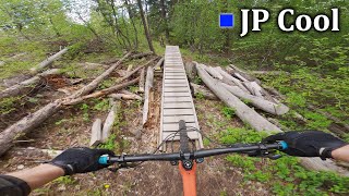
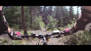
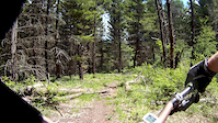
JP is a Merritt must ride. From the edge of Midday Valley Road, twist and turn through the lush forest, dipping down to a quietly flowing creek, then up a short climb to the top of the ridge and back down again with flow that is singletrack perfection. Once back at Midday Valley Road, take Cross Cut to Sanchez to the parking lot.

Local Trail Association

Recent Activity on Trail

Past Week
  • 13 rides
  • 49 miles average
6 Months
  • 24 rides
  • 31 miles avg distance
All
  • 202 rides
  • Last: Jun 17, 2026
c1c2c3c4
January
February
March
April
May
June
July
August
September
October
November
December
update trails status or condition

JP Cool Trail Reports

statusdatedescription
May 12, 2026 @ 9:30am (America/Vancouver)
May 12, 2026
a bit dry, but overall riding great!
Apr 27, 2026 @ 12:23pm (America/Vancouver)
Apr 27, 2026
May 24, 2025 @ 5:34pm
May 24, 2025
Bonus Trials move. You need to do a front wheel lift to get on the teeter totter
Jul 21, 2024 @ 3:29pm
Jul 21, 2024
Jun 10, 2024 @ 1:25pm
Jun 10, 2024
reporter
trees have been cleared
more »
Status:
on May 12, 2026
Dry
Avg: 3.85 (8 votes)
Your vote: 0

view (907)
close
3D
Trail Conditions
  • Unknown
  • Snow Groomed
  • Snow Packed
  • Snow Covered
  • Snow Cover Partial
  • Freeze/thaw Cycle
  • Icy
  • Prevalent Mud
  • Wet
  • Variable
  • Ideal
  • Dry
  • Very Dry
Trail Flow (Ridden Direction)
Trailforks scans users ridelogs to determine the most popular direction each trail is ridden. A good flowing trail network will have most trails flowing in a single direction according to their intension.
The colour categories are based on what percentage of riders are riding a trail in its intended direction.
  • > 96%
  • > 90%
  • > 80%
  • > 70%
  • > 50%
  • < 50%
  • bi-directional trail
  • no data
Trail Last Ridden
Trailforks scans ridelogs to determine the last time a trail was ridden.
  • < 2 days
  • < 1 week
  • < 2 weeks
  • < 1 month
  • < 6 months
  • > 6 months
Trail Ridden Direction
The intended direction a trail should be ridden.
  • Downhill Only
  • Downhill Primary
  • Both Directions
  • Uphill Primary
  • Uphill Only
  • One Direction
Contribute Details
Colors indicate trail is missing specified detail.
  • Description
  • Photos
  • Description & Photos
  • Videos
Trail Popularity ?
Trailforks scans ridelogs to determine which trails are ridden the most in the last 9 months. Trails are compared with nearby trails in the same city region with a possible 25 colour shades. Think of this as a heatmap, more rides = more kinetic energy = warmer colors.
  • most popular
  • popular
  • less popular
  • not popular
ATV/ORV/OHV Filter
Max Vehicle Width
inches
US Cell Coverage
Legend
cell carrier legend

Radar Time
Activity Recordings
Trailforks uses anonymized public activity data. ?
Activity Recordings
Trailforks uses anonymized public activity data. ?
Personal Heatmap
Activity Types
all / none
Options
2
Date range month
Winter Trails
Warning A routing network for winter maps does not exist. Selecting trails using the winter trails layer has been disabled.
Missing Trails
Most Popular
Least Popular
Trails are colored based on popularity. The more popular a trail is, the more red. Less popular trails trend towards green.
Jump Magnitude Heatmap
Heatmap of where riders jump on trails. Zoom in to see individual jumps, click circles to view jump details.
BC Backroad Status

Service Road Atlas is a free to use, community-driven service for viewing and creating reports on the numerous back-country service roads around B.C. and Alberta.

map legend
Slope Aspect
Direction the slope faces
Flat N NE E SE S SW W NW
Trails Deemphasized
Trails are shown in grey.
disable
Only show trails with no bike usage.
Enable
Suggested Layers
Based on selected activity type

    Save the current map location and zoom level as your default home location whenever this page is loaded.

    Save
        Directions to jp-cool trailhead (50.077060, -120.863920)

        Photos

        21 more »
        118 |
        Jul 19, 2021 @ 6:53pm
        Jul 19, 2021
        103 |
        May 27, 2020 @ 9:44pm
        May 27, 2020
        383 |
        Mar 20, 2007 @ 6:46pm
        Mar 20, 2007
        428 |
        Mar 20, 2007 @ 6:46pm
        Mar 20, 2007

        Videos

        4 more »
        JP Cool - Coutlee plateau
        9:59 | 196 | Jun 4, 2024 , Merritt
        Coultee Plateau
        6:00 | 358 | Nov 5, 2020 , Merritt
        JP Cool
        587 | Nov 7, 2016 , Merritt
        Coutlee Plateau
        5:23 | 568 | Jul 5, 2013 , Merritt

        Routes with this trail

        35 miles 5,334 ft 10 Loop
        THE MERRITT CROWN 120KM, 60KM & RELAY 3,000M of Elevation. 12-Hour Time Limit. The 7th Annual MTB...
        15 miles 2,034 ft 4 Loop
        Section 4 of the Merritt Crown
        26 miles 4,611 ft 54 Loop

        Reviews / Comments

        No reviews yet, be the first to write a review or ask a question.
        Use trail reports to comment on trail conditions.


        We hope you've been enjoying Trailforks!

        Create a FREE account to view trail comments and much more.

        • By pewterTF Pro & contributors
        • #7470 - 3,779 views

        Frequently Asked Questions About JP Cool

        Where is JP Cool located?
        JP Cool is located in Coutlee Plateau, Merritt, British Columbia, Canada. It is part of the Coutlee Plateau trail network. The trailhead is located at coordinates 50.07706, -120.86392.
        How hard is JP Cool?
        JP Cool is rated as Blue difficulty. The average grade is 7.372%.
        What is the elevation gain for JP Cool?
        JP Cool has 24 m of elevation gain. The trail has 189 m of elevation descent. The elevation ranges from 797 m to 963 m.
        Is JP Cool a point to point trail?
        JP Cool is not a point to point trail. The direction is Downhill Primary. The trail type is singletrack.

        Hit the Trail

        Open in App

        Get this trail on your phone instantly.
        open trail in app

        Download Trail

        Save to wishlist, Garmin & download.
        save the trail

        Find Related Routes

        Find routes and users activities that include this trail.
        find routes for this trail

        You must enter a description before submitting.