more stats
2,799 ft
Distance
4 ft
Climb
-323 ft
Descent
00:06:11
Avg time
-319 ft
Altitude change
5,115 ft
Altitude min
5,435 ft
Altitude max
5,434 ft
Altitude start
5,115 ft
Altitude end
-11.4%
Grade
-29.6%
Grade max
1.7%
Grade min
292 ft
Distance climb
2,185 ft
Distance down
322 ft
Distance flat
00:06:11
Avg time

Airlines Details

  • Activities
    • Mountain Bike
    • E-Bike
  • Riding Area
  • Ref Number
    #17
  • Difficulty Rating
  • Voted Difficulty
    Black (1 vote)
  • Local Popularity
    70 in Mountain Biking [+]
    • 55 in E-Biking
  • Global Ranking
    #46554 in Mountain Biking [+]
    • #86661 in E-Biking
  • Trail Type
    Machine Groomed
  • Bike Type
    DH
  • Direction
    One Direction[+]
    • One Direction for E-Biking
  • Physical Rating
    Moderate
  • Trail Visibility
    Always easy to follow
  • Season
    June -September
  • eBike Allowed
  • TTFs on Trail
    Berm, Drop, Jump, Gap Jump
  • Year Opened
    2013
  • Land Owner
    Les Gets Bikepark

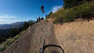
une piste au départ du haut du télésiège des Nauchets est une jump line réservées aux experts et aménagée pour la pratique du freestyle. Composée de 26 modules, step up, step down et transfers, le jump park a été refait à neuf pour l'été 2020

Access Info

From Nauchets Chairlifts

Bike Park

Local Trail Association
  • trail association logo
  • Please consider joining or donating to the local trail association to support
    trail development & maintenance.

Recent Activity on Trail

Past Week
  • 1 rides
  • 43.0 km average
6 Months
  • 2 rides
  • 43.7 km avg distance
All
  • 167 rides
  • Last: Jun 22, 2026
c1c2c3c4
January
February
March
April
May
June
July
August
September
October
November
December
Status:
on May 22, 2026
Ideal
Avg: 4.16 (6 votes)
Your vote: 0

view (2,354)
close
3D
Trail Conditions
  • Unknown
  • Snow Groomed
  • Snow Packed
  • Snow Covered
  • Snow Cover Partial
  • Freeze/thaw Cycle
  • Icy
  • Prevalent Mud
  • Wet
  • Variable
  • Ideal
  • Dry
  • Very Dry
Trail Flow (Ridden Direction)
Trailforks scans users ridelogs to determine the most popular direction each trail is ridden. A good flowing trail network will have most trails flowing in a single direction according to their intension.
The colour categories are based on what percentage of riders are riding a trail in its intended direction.
  • > 96%
  • > 90%
  • > 80%
  • > 70%
  • > 50%
  • < 50%
  • bi-directional trail
  • no data
Trail Last Ridden
Trailforks scans ridelogs to determine the last time a trail was ridden.
  • < 2 days
  • < 1 week
  • < 2 weeks
  • < 1 month
  • < 6 months
  • > 6 months
Trail Ridden Direction
The intended direction a trail should be ridden.
  • Downhill Only
  • Downhill Primary
  • Both Directions
  • Uphill Primary
  • Uphill Only
  • One Direction
Contribute Details
Colors indicate trail is missing specified detail.
  • Description
  • Photos
  • Description & Photos
  • Videos
Trail Popularity ?
Trailforks scans ridelogs to determine which trails are ridden the most in the last 9 months. Trails are compared with nearby trails in the same city region with a possible 25 colour shades. Think of this as a heatmap, more rides = more kinetic energy = warmer colors.
  • most popular
  • popular
  • less popular
  • not popular
ATV/ORV/OHV Filter
Max Vehicle Width
inches
US Cell Coverage
Legend
cell carrier legend

Radar Time
Activity Recordings
Trailforks uses anonymized public activity data. ?
Activity Recordings
Trailforks uses anonymized public activity data. ?
Personal Heatmap
Activity Types
all / none
Options
2
Date range month
Winter Trails
Warning A routing network for winter maps does not exist. Selecting trails using the winter trails layer has been disabled.
Missing Trails
Most Popular
Least Popular
Trails are colored based on popularity. The more popular a trail is, the more red. Less popular trails trend towards green.
Jump Magnitude Heatmap
Heatmap of where riders jump on trails. Zoom in to see individual jumps, click circles to view jump details.
BC Backroad Status

Service Road Atlas is a free to use, community-driven service for viewing and creating reports on the numerous back-country service roads around B.C. and Alberta.

map legend
Slope Aspect
Direction the slope faces
Flat N NE E SE S SW W NW
Trails Deemphasized
Trails are shown in grey.
disable
Only show trails with no bike usage.
Enable
Suggested Layers
Based on selected activity type

    Save the current map location and zoom level as your default home location whenever this page is loaded.

    Save
        Directions to airlines trailhead (46.140200, 6.695220)

        Photos

        84 more »
        147 |
        Jan 28, 2021 @ 12:27am
        Jan 28, 2021
        226 |
        Dec 14, 2018 @ 8:52am
        Dec 14, 2018
        110 |
        Sep 2, 2018 @ 10:10am
        Sep 2, 2018
        647 |
        Sep 21, 2017 @ 5:31am
        Sep 21, 2017

        Videos

        19 more »
        youtuber Les Gets - Jump Park 2023
        2:01 | 387 | Aug 25, 2023 , Les Gets
        OH NO! LILA SE VUELVE A CAER  Les Gets...
        3:02 | 299 | Oct 3, 2021 , Les Gets
        Les Gets Bike Park - Jump Park POV
        0:32 | 545 | Aug 24, 2018 , Les Gets
        Brutal Crash in Les Gets
        0:16 | 39869 | Sep 4, 2015 , Les Gets

        Links

        Reviews / Comments

        No reviews yet, be the first to write a review or ask a question.
        Use trail reports to comment on trail conditions.


        We hope you've been enjoying Trailforks!

        Create a FREE account to view trail comments and much more.

        • By valducrettetTF Pro & contributors
        • #39662 - 3,379 views

        Frequently Asked Questions About Airlines

        Where is Airlines located?
        Airlines is located in Les Gets Bike Park, Les Gets, France. It is part of the Les Gets Bike Park trail network. The trailhead is located at coordinates 46.1402, 6.69522.
        How hard is Airlines?
        Airlines is rated as Proline difficulty. The physical rating is Moderate. The average grade is 11.4%.
        What is the elevation gain for Airlines?
        Airlines has 4 ft of elevation gain. The trail has 323 ft of elevation descent. The elevation ranges from 5,115 ft to 5,435 ft.
        Is Airlines a point to point trail?
        Yes, Airlines is a point to point trail. The direction is One Direction. The trail type is machine groomed.

        Hit the Trail

        Open in App

        Get this trail on your phone instantly.
        open trail in app

        Download Trail

        Save to wishlist, Garmin & download.
        save the trail

        Find Related Routes

        Find routes and users activities that include this trail.
        find routes for this trail

        You must enter a description before submitting.