more stats
2.9 miles
Distance
120 ft
Climb
-468 ft
Descent
00:23:42
Avg time
-350 ft
Altitude change
381 ft
Altitude min
731 ft
Altitude max
731 ft
Altitude start
381 ft
Altitude end
-2.3%
Grade
-25.5%
Grade max
34.9%
Grade min
2,723 ft
Distance climb
2 miles
Distance down
3,471 ft
Distance flat
00:23:42
Avg time

Junction Track Details

  • Activities
    • Mountain Bike
    • E-Bike
  • Riding Area
  • Ref Number
    #14
  • Difficulty Rating
  • Voted Difficulty
    Black Diamond (2 votes)
  • Local Popularity
    85 in Mountain Biking [+]
    • 80 in E-Biking
  • Global Ranking
    #2251 in Mountain Biking [+]
    • #4321 in E-Biking
  • Trail Type
    Singletrack
  • Bike Type
    AM, XC
  • Direction
    Downhill Primary
  • Dogs Allowed
    Yes
  • eBike Allowed
    Yes up to Class 1
  • TTFs on Trail
    Berm, Bridge, Rock Garden

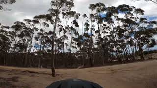
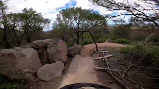
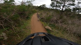
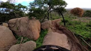
A diverse trail linking the Stockyards and Kurrajong areas, this track has a number of dirt jumps, rock gardens and flowing earth berms, suitable to be ridden in both directions this track provides a challenging climb when heading from Kurrajong to Stockyards. The northern section includes flowing earth berms and boardwalks through open Eucalypt woodlands.

Local Trail Association
Traditionally Indigenous Territory

Recent Activity on Trail

Past Week
  • 4 rides
  • 15 miles average
6 Months
  • 90 rides
  • 16 miles avg distance
All
  • 840 rides
  • Last: Jul 4, 2026
c1c2c3c4
January
February
March
April
May
June
July
August
September
October
November
December
update trails status or condition

Junction Track Trail Reports

statusdatedescription
Dec 30, 2025 @ 9:19am (Australia/Melbourne)
Dec 29, 2025
Sep 1, 2025 @ 10:18am
Sep 1, 2025
Couple of trees down over the track
Dec 23, 2024 @ 2:05pm
Dec 23, 2024
Mostly good but needs a bit of love in a few rutted spots in the black section after the road climb.
Aug 26, 2024 @ 11:20am
Aug 26, 2024
Feb 3, 2024 @ 1:08pm
Feb 3, 2024
more »
Status:
on Dec 30, 2025
Very Dry
Avg: 4.4 (21 votes)
Your vote: 0

view (8,851)
close
3D
Trail Conditions
  • Unknown
  • Snow Groomed
  • Snow Packed
  • Snow Covered
  • Snow Cover Partial
  • Freeze/thaw Cycle
  • Icy
  • Prevalent Mud
  • Wet
  • Variable
  • Ideal
  • Dry
  • Very Dry
Trail Flow (Ridden Direction)
Trailforks scans users ridelogs to determine the most popular direction each trail is ridden. A good flowing trail network will have most trails flowing in a single direction according to their intension.
The colour categories are based on what percentage of riders are riding a trail in its intended direction.
  • > 96%
  • > 90%
  • > 80%
  • > 70%
  • > 50%
  • < 50%
  • bi-directional trail
  • no data
Trail Last Ridden
Trailforks scans ridelogs to determine the last time a trail was ridden.
  • < 2 days
  • < 1 week
  • < 2 weeks
  • < 1 month
  • < 6 months
  • > 6 months
Trail Ridden Direction
The intended direction a trail should be ridden.
  • Downhill Only
  • Downhill Primary
  • Both Directions
  • Uphill Primary
  • Uphill Only
  • One Direction
Contribute Details
Colors indicate trail is missing specified detail.
  • Description
  • Photos
  • Description & Photos
  • Videos
Trail Popularity ?
Trailforks scans ridelogs to determine which trails are ridden the most in the last 9 months. Trails are compared with nearby trails in the same city region with a possible 25 colour shades. Think of this as a heatmap, more rides = more kinetic energy = warmer colors.
  • most popular
  • popular
  • less popular
  • not popular
ATV/ORV/OHV Filter
Max Vehicle Width
inches
US Cell Coverage
Legend
cell carrier legend

Radar Time
Activity Recordings
Trailforks uses anonymized public activity data. ?
Activity Recordings
Trailforks uses anonymized public activity data. ?
Personal Heatmap
Activity Types
all / none
Options
2
Date range month
Winter Trails
Warning A routing network for winter maps does not exist. Selecting trails using the winter trails layer has been disabled.
Missing Trails
Most Popular
Least Popular
Trails are colored based on popularity. The more popular a trail is, the more red. Less popular trails trend towards green.
Jump Magnitude Heatmap
Heatmap of where riders jump on trails. Zoom in to see individual jumps, click circles to view jump details.
BC Backroad Status

Service Road Atlas is a free to use, community-driven service for viewing and creating reports on the numerous back-country service roads around B.C. and Alberta.

map legend
Slope Aspect
Direction the slope faces
Flat N NE E SE S SW W NW
Trails Deemphasized
Trails are shown in grey.
disable
Only show trails with no bike usage.
Enable
Suggested Layers
Based on selected activity type

    Save the current map location and zoom level as your default home location whenever this page is loaded.

    Save
        Directions to junction-track trailhead (-37.935990, 144.435870)

        Photos

        28 more »
        38 |
        Nov 27, 2025 @ 5:33am
        Nov 27, 2025
        52 |
        Jan 12, 2024 @ 3:08am
        Jan 12, 2024
        175 |
        Jul 11, 2021 @ 12:45am
        Jul 11, 2021
        255 |
        Jun 17, 2020 @ 1:54am
        Jun 17, 2020

        Videos

        7 more »
        Junction Track 14 - AKA Giant Slalom, You...
        5:46 | 374 | Dec 22, 2023 , You Yangs
        Junction Track 14 - You Yangs December 2023
        2:48 | 463 | Dec 21, 2023 , You Yangs
        You Yangs Track 14, Junction from Stockyards -...
        4:50 | 681 | Jan 6, 2023 , You Yangs
        Track 14 - Junction Black Section
        2:36 | 813 | Nov 15, 2020 , You Yangs

        Routes with this trail

        19 miles 1,562 ft 7 Out & Back
        Nice flowy single track that cross both sides of the You Yangs - beware, going over the the other side and...
        24 miles 1,806 ft 9
        A nice introductory combo of most of the blue and green trails around the You Yangs

        5 Reviews & Comments


        We hope you've been enjoying Trailforks!

        Create a FREE account to view trail comments and much more.

        • By ForkeSealTF Pro & contributors
        • #8342 - 5,619 views

        Frequently Asked Questions About Junction Track

        Where is Junction Track located?
        Junction Track is located in You Yangs Regional Park, You Yangs, Australia. It is part of the You Yangs Regional Park trail network. The trailhead is located at coordinates -37.93599, 144.43587.
        How hard is Junction Track?
        Junction Track is rated as Black Diamond difficulty. The average grade is 2.3%.
        What is the elevation gain for Junction Track?
        Junction Track has 120 ft of elevation gain. The trail has 468 ft of elevation descent. The elevation ranges from 381 ft to 731 ft.
        Is Junction Track a point to point trail?
        Junction Track is not a point to point trail. The direction is Downhill Primary. The trail type is singletrack.

        Hit the Trail

        Open in App

        Get this trail on your phone instantly.
        open trail in app

        Download Trail

        Save to wishlist, Garmin & download.
        save the trail

        Find Related Routes

        Find routes and users activities that include this trail.
        find routes for this trail

        You must enter a description before submitting.