more stats
4.6 miles
Distance
184 ft
Climb
-1,914 ft
Descent
00:41:19
Avg time
-1,729 ft
Altitude change
4,906 ft
Altitude min
6,803 ft
Altitude max
6,777 ft
Altitude start
5,049 ft
Altitude end
-7.2%
Grade
-40.8%
Grade max
21.9%
Grade min
3,422 ft
Distance climb
4 miles
Distance down
1,293 ft
Distance flat
00:41:19
Avg time

Just Outstanding Details

  • Activities
    • Mountain Bike
    • E-Bike
    • Hike
    • Trail Running
    • Dirtbike/Moto
  • Riding Area
    Southern Sequoia National Forest
    Wofford Heights, California
  • Ref Number
    #32E46
  • AKA
    JO
  • Difficulty Rating
  • Voted Difficulty
    Blue (1 vote)
  • Local Popularity
    100 in Mountain Biking [+]
    • 100 in E-Biking
    • 5 in Trail Running
    • 5 in Hiking
    • 95 in Dirtbiking
  • Global Ranking
    #24732 in Mountain Biking [+]
    • #2195 in E-Biking
    • #128230 in Trail Running
    • #1884 in Hiking
    • #210 in Dirtbiking
  • Trail Type
    Singletrack
  • Bike Type
    DH, AM, XC
  • Direction
    Downhill Primary
    Popular Direction Shown
  • Season
    May-December
  • Dogs Allowed
    Yes
  • eBike Allowed
    Yes up to Class 1
  • Land Owner

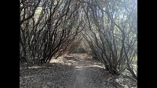
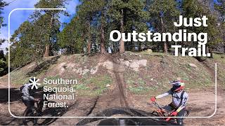
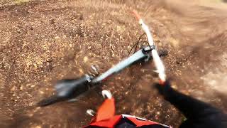
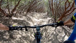
Just Outstanding is a fun downhill singletrack ride through the trees. It offers some nice corners, semi-technical areas as well as some spots where you can really fly if you dare. And of course there is the famous Manzanita Tunnel section where you are riding through a tunnel of Manzanita trees that is quite the experience.

Trail Supporters

  • USFS
    Land Manager
Local Trail Association
Traditionally Indigenous Territory

Recent Activity on Trail

Past Week
  • 3 rides
  • 21 miles average
6 Months
  • 19 rides
  • 16 miles avg distance
All
  • 152 rides
  • Last: Jun 21, 2026
c1c2c3c4
January
February
March
April
May
June
July
August
September
October
November
December
update trails status or condition

Just Outstanding Trail Reports

statusdatedescription
Jun 10, 2026 @ 8:28am (America/Los_Angeles)
Jun 10, 2026
Just Outstanding is in fairly good shape but the top part is overgrown with tall grass making it hard to see branches in the trail in advance. No...
May 17, 2026 @ 6:16pm (America/Los_Angeles)
May 17, 2026
Trail is a little overgrown with short grasses, nothing that will knock you off your bike but it makes it slightly hard to see the trail at some...
Mar 21, 2026 @ 9:58am (America/Los_Angeles)
Mar 21, 2026
Good condition, many downed trees on upper section. Already dry in late March.
Nov 27, 2025 @ 1:30pm (America/Los_Angeles)
Nov 27, 2025
Some patches of snow in the shade up top, but none on the trails. Top half of the singletrack was primo hero dirt. Grip and rip, with a couple wet...
Oct 12, 2025 @ 7:31pm (America/Los_Angeles)
Oct 12, 2025
Rode this on 10/9, starting at 3:30 pm. Dry, dusty, traction at times hard to come by on dust and gravel over hardpack. Really fun nonetheless!...
more »
Status:
on Jun 10, 2026
Dry
Avg: 4.58 (19 votes)
Your vote: 0

view (969)
close
3D
Trail Conditions
  • Unknown
  • Snow Groomed
  • Snow Packed
  • Snow Covered
  • Snow Cover Partial
  • Freeze/thaw Cycle
  • Icy
  • Prevalent Mud
  • Wet
  • Variable
  • Ideal
  • Dry
  • Very Dry
Trail Flow (Ridden Direction)
Trailforks scans users ridelogs to determine the most popular direction each trail is ridden. A good flowing trail network will have most trails flowing in a single direction according to their intension.
The colour categories are based on what percentage of riders are riding a trail in its intended direction.
  • > 96%
  • > 90%
  • > 80%
  • > 70%
  • > 50%
  • < 50%
  • bi-directional trail
  • no data
Trail Last Ridden
Trailforks scans ridelogs to determine the last time a trail was ridden.
  • < 2 days
  • < 1 week
  • < 2 weeks
  • < 1 month
  • < 6 months
  • > 6 months
Trail Ridden Direction
The intended direction a trail should be ridden.
  • Downhill Only
  • Downhill Primary
  • Both Directions
  • Uphill Primary
  • Uphill Only
  • One Direction
Contribute Details
Colors indicate trail is missing specified detail.
  • Description
  • Photos
  • Description & Photos
  • Videos
Trail Popularity ?
Trailforks scans ridelogs to determine which trails are ridden the most in the last 9 months. Trails are compared with nearby trails in the same city region with a possible 25 colour shades. Think of this as a heatmap, more rides = more kinetic energy = warmer colors.
  • most popular
  • popular
  • less popular
  • not popular
ATV/ORV/OHV Filter
Max Vehicle Width
inches
US Cell Coverage
Legend
cell carrier legend

Radar Time
Activity Recordings
Trailforks uses anonymized public activity data. ?
Activity Recordings
Trailforks uses anonymized public activity data. ?
Personal Heatmap
Activity Types
all / none
Options
2
Date range month
Winter Trails
Warning A routing network for winter maps does not exist. Selecting trails using the winter trails layer has been disabled.
Missing Trails
Most Popular
Least Popular
Trails are colored based on popularity. The more popular a trail is, the more red. Less popular trails trend towards green.
Jump Magnitude Heatmap
Heatmap of where riders jump on trails. Zoom in to see individual jumps, click circles to view jump details.
BC Backroad Status

Service Road Atlas is a free to use, community-driven service for viewing and creating reports on the numerous back-country service roads around B.C. and Alberta.

map legend
Slope Aspect
Direction the slope faces
Flat N NE E SE S SW W NW
Trails Deemphasized
Trails are shown in grey.
disable
Only show trails with no bike usage.
Enable
Suggested Layers
Based on selected activity type

    Save the current map location and zoom level as your default home location whenever this page is loaded.

    Save
        Directions to just-outstanding trailhead (35.705370, -118.564510)

        Photos

        76 more »
        418 |
        Mar 8, 2010 @ 6:50pm
        Mar 8, 2010
        838 |
        May 31, 2015 @ 9:57am
        May 31, 2015
        15 |
        May 25, 2026 @ 8:43pm
        May 25, 2026
        10 |
        May 25, 2026 @ 8:43pm
        May 25, 2026

        Videos

        12 more »
        youtuber Just Outstanding Trail - Kernville, CA
        15:10 | 808 | Oct 15, 2018 , Wofford Heights
        Mountain Biking Outstanding Trail Sequoia...
        29:59 | 22 | May 2, 2026 , Wofford Heights
        Just Outstanding trail , mid April 2022
        15:29 | 314 | Apr 23, 2022 , Wofford Heights
        Just Outstanding
        21:44 | 405 | May 26, 2021 , Wofford Heights

        Routes with this trail

        5.0 11 miles 923 ft 3 Shuttled
        A common shuttled route for riding the Just Outstanding (JO) trail.
        5.0 11 miles 1,051 ft 7
        A alternate way down form Wagy Ridge that brings you out closer to the south end of Lake Isabella
        4.0 15 miles 708 ft 6 Point to Point
        noticed trails going down from to dutch flat. I wanted to go up to Wofford heights so I can stop by kern...

        8 Reviews & Comments


        We hope you've been enjoying Trailforks!

        Create a FREE account to view trail comments and much more.

        • By aoneal & contributors
        • #31676 - 15,631 views

        Frequently Asked Questions About Just Outstanding

        Where is Just Outstanding located?
        Just Outstanding is located in Southern Sequoia National Forest, Wofford Heights, California, United States. It is part of the Southern Sequoia National Forest trail network. The trailhead is located at coordinates 35.70537, -118.56451.
        How hard is Just Outstanding?
        Just Outstanding is rated as Blue difficulty. The average grade is 7.2%.
        What is the elevation gain for Just Outstanding?
        Just Outstanding has 184 ft of elevation gain. The trail has 1,914 ft of elevation descent. The elevation ranges from 4,906 ft to 6,803 ft.
        Is Just Outstanding a point to point trail?
        Just Outstanding is not a point to point trail. The direction is Downhill Primary. The trail type is singletrack.

        Hit the Trail

        Open in App

        Get this trail on your phone instantly.
        open trail in app

        Download Trail

        Save to wishlist, Garmin & download.
        save the trail

        Find Related Routes

        Find routes and users activities that include this trail.
        find routes for this trail

        You must enter a description before submitting.