

Open in App
Get this trail on your phone instantly.

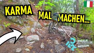
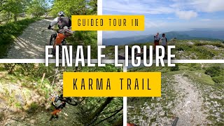
The second longest ever EWS stage: 8.3km and 1100m drop for a technical and complete trail.
It officially started on the top of Monte Carmo (highest peak of the region) at 1389m o.s.l., now that is not reachable by bikes anymore and the trail starts from the col a few hundred meters below. Long, techy, steep and tight: everything fun for advanced riders.
Exit the E80 highway in Pietra Ligure. Keep going towards the sea and you'll get to Pietra Ligure. You'll then be able to drive toward the mountains in order to reach Val Maremola towns and trails.
Other option would be the E80 exit in Finale Ligure. Keep going towards the sea until you catch the SS1 Via Aurelia and move west until Pietra Ligure.
This trail is for experienced riders. Make sure you talk to an expert, professional guide for the best experience. Given its nature, the trail can change after weather happenings and season changes. Always pay attention.
| c1 | c2 | c3 | c4 |
|---|---|---|---|
January | February | March | April |
May | June | July | August |
September | October | November | December |

Service Road Atlas is a free to use, community-driven service for viewing and creating reports on the numerous back-country service roads around B.C. and Alberta.
Save the current map location and zoom level as your default home location whenever this page is loaded.
SaveWe hope you've been enjoying Trailforks!
Create a FREE account to view trail comments and much more.
You must enter a description before submitting.

