more stats
1,506 ft
Distance
-90 ft
Descent
00:07:29
Avg time
-90 ft
Altitude change
7,915 ft
Altitude min
8,005 ft
Altitude max
8,005 ft
Altitude start
7,917 ft
Altitude end
-6%
Grade
-12.5%
Grade max
-1.8%
Grade min
1,460 ft
Distance down
46 ft
Distance flat
00:07:29
Avg time

Karpiel (Upper) Details

  • Activities
    • Mountain Bike
    • E-Bike
  • Riding Area
    Northstar at Tahoe Resort
    Truckee, California
  • Difficulty Rating
  • Voted Difficulty
    Double Black Diamond (3 votes)
  • Local Popularity
    90 in Mountain Biking [+]
    • 90 in E-Biking
  • Global Ranking
    #44652 in Mountain Biking [+]
    • #37184 in E-Biking
  • Trail Type
    Singletrack
  • Bike Type
    DH
  • Physical Rating
    Hard
  • Season
    Summer
  • Dogs Allowed
    Yes
  • eBike Allowed
    Yes up to Class 1
  • TTFs on Trail
    Drop, Jump

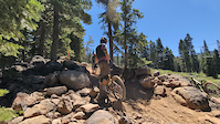
A technical double Black off of Vista.

Access Info

From the top of Vista the trailhead is next to Sticks & Stones.

Bike Park

Traditionally Indigenous Territory

Recent Activity on Trail

Past Week
  • 4 rides
  • 14 miles average
6 Months
  • 4 rides
  • 14 miles avg distance
All
  • 273 rides
  • Last: Jun 14, 2026
c1c2c3c4
January
February
March
April
May
June
July
August
September
October
November
December
update trails status or condition

Karpiel (Upper) Trail Reports

statusdatedescription
Jul 13, 2023 @ 4:04am
Jul 13, 2023
Dawg why is the trail filled with moon dust. i could not see shit
Jul 9, 2023 @ 4:22am
Jul 9, 2023
Sep 22, 2022 @ 11:26am
Sep 22, 2022
Sep 18, 2022 @ 12:37am
Sep 18, 2022
hella loose on the steep gnarly parts of the trail
Sep 3, 2022 @ 11:46am
Sep 3, 2022
more »
Status:
on Jul 13, 2023
Very Dry
Avg: 4.52 (11 votes)
Your vote: 0

view (3,614)
close
3D
Trail Conditions
  • Unknown
  • Snow Groomed
  • Snow Packed
  • Snow Covered
  • Snow Cover Partial
  • Freeze/thaw Cycle
  • Icy
  • Prevalent Mud
  • Wet
  • Variable
  • Ideal
  • Dry
  • Very Dry
Trail Flow (Ridden Direction)
Trailforks scans users ridelogs to determine the most popular direction each trail is ridden. A good flowing trail network will have most trails flowing in a single direction according to their intension.
The colour categories are based on what percentage of riders are riding a trail in its intended direction.
  • > 96%
  • > 90%
  • > 80%
  • > 70%
  • > 50%
  • < 50%
  • bi-directional trail
  • no data
Trail Last Ridden
Trailforks scans ridelogs to determine the last time a trail was ridden.
  • < 2 days
  • < 1 week
  • < 2 weeks
  • < 1 month
  • < 6 months
  • > 6 months
Trail Ridden Direction
The intended direction a trail should be ridden.
  • Downhill Only
  • Downhill Primary
  • Both Directions
  • Uphill Primary
  • Uphill Only
  • One Direction
Contribute Details
Colors indicate trail is missing specified detail.
  • Description
  • Photos
  • Description & Photos
  • Videos
Trail Popularity ?
Trailforks scans ridelogs to determine which trails are ridden the most in the last 9 months. Trails are compared with nearby trails in the same city region with a possible 25 colour shades. Think of this as a heatmap, more rides = more kinetic energy = warmer colors.
  • most popular
  • popular
  • less popular
  • not popular
ATV/ORV/OHV Filter
Max Vehicle Width
inches
US Cell Coverage
Legend
cell carrier legend

Radar Time
Activity Recordings
Trailforks uses anonymized public activity data. ?
Activity Recordings
Trailforks uses anonymized public activity data. ?
Personal Heatmap
Activity Types
all / none
Options
2
Date range month
Winter Trails
Warning A routing network for winter maps does not exist. Selecting trails using the winter trails layer has been disabled.
Missing Trails
Most Popular
Least Popular
Trails are colored based on popularity. The more popular a trail is, the more red. Less popular trails trend towards green.
Jump Magnitude Heatmap
Heatmap of where riders jump on trails. Zoom in to see individual jumps, click circles to view jump details.
BC Backroad Status

Service Road Atlas is a free to use, community-driven service for viewing and creating reports on the numerous back-country service roads around B.C. and Alberta.

map legend
Slope Aspect
Direction the slope faces
Flat N NE E SE S SW W NW
Trails Deemphasized
Trails are shown in grey.
disable
Only show trails with no bike usage.
Enable
Suggested Layers
Based on selected activity type

    Save the current map location and zoom level as your default home location whenever this page is loaded.

    Save
        Directions to karpiel-upper trailhead (39.248080, -120.124890)

        Photos

        20 more »
        81 |
        May 19, 2026 @ 12:12am
        May 19, 2026
        136 |
        Jul 29, 2021 @ 10:03am
        Jul 29, 2021
        281 |
        Aug 26, 2019 @ 9:18am
        Aug 26, 2019
        315 |
        Oct 31, 2018 @ 5:52pm
        Oct 31, 2018

        Videos

        12 more »
        youtuber Karpiel / Northstar Bike Park
        5:38 | 151 | Aug 28, 2024 , Truckee
        Northstar BikePark First Time Blind Full...
        19:57 | 230 | Jul 11, 2023 , Truckee
        OTB Karpiel
        0:10 | | Jul 19, 2024 , Truckee
        2015 Karpiel DH Race Run
        5:42 | 634 | Dec 5, 2015 , Truckee

        2 Reviews & Comments


        We hope you've been enjoying Trailforks!

        Create a FREE account to view trail comments and much more.

        • By chriscliffordTF Pro & contributors
        • #5705 - 6,858 views

        Frequently Asked Questions About Karpiel (Upper)

        Where is Karpiel (Upper) located?
        Karpiel (Upper) is located in Northstar at Tahoe Resort, Truckee, California, United States. It is part of the Northstar at Tahoe Resort trail network. The trailhead is located at coordinates 39.24808, -120.12489.
        How hard is Karpiel (Upper)?
        Karpiel (Upper) is rated as Double Black Diamond difficulty. The physical rating is Hard. The average grade is 6%.
        What is the elevation gain for Karpiel (Upper)?
        The trail has 90 ft of elevation descent. The elevation ranges from 7,915 ft to 8,005 ft.
        How long is Karpiel (Upper)?
        Karpiel (Upper) is 1,506 ft long. The trail type is singletrack.

        Hit the Trail

        Open in App

        Get this trail on your phone instantly.
        open trail in app

        Download Trail

        Save to wishlist, Garmin & download.
        save the trail

        Find Related Routes

        Find routes and users activities that include this trail.
        find routes for this trail

        You must enter a description before submitting.