more stats
1,929 ft
Distance
34 ft
Climb
-199 ft
Descent
00:10:34
Avg time
-165 ft
Altitude change
1,289 ft
Altitude min
1,489 ft
Altitude max
1,453 ft
Altitude start
1,289 ft
Altitude end
-8.5%
Grade
-41.5%
Grade max
13.2%
Grade min
453 ft
Distance climb
1,444 ft
Distance down
33 ft
Distance flat
00:10:34
Avg time

Katore Jumps Details

  • Activities
    • Mountain Bike
    • E-Bike
  • Riding Area
  • AKA
    K Jumps
  • Difficulty Rating
  • Voted Difficulty
    Secondary Access Road/Trail (5 votes)
  • Local Popularity
    50 in Mountain Biking [+]
    • 65 in E-Biking
  • Global Ranking
    #40197 in Mountain Biking [+]
    • #40326 in E-Biking
  • Trail Type
    Singletrack
  • Bike Type
    DH, AM
  • Direction
    Downhill Primary
  • Climb Difficulty
    Green
  • Physical Rating
    Easy
  • Dogs Allowed
    Yes
  • eBike Allowed
    Yes up to Class 1
  • TTFs on Trail
    Berm, Drop, Jump, Gap Jump, Wallride

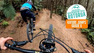
Originally an old skid road with a few natural hips and lumps. However, over the years this trail has turned into a consistent jumps line. Not the biggest jumps out there but still a lot of fun. Speed checks are necessary with a lot of the jumps as there are a few awkward ones which you need to brake a lot for. Also a new gap jump at the end. A solid jump with a flat landing which eventually slopes into a nice landing. A fairly mighty huck if you clear it to the slope. Stay low on the step downs before it and you will be fine. Also avoid this trail in the wet as it bogs up really badly in some places.

Local Trail Association

Recent Activity on Trail

Past Week
  • 0 rides
  •  
6 Months
  • 28 rides
  • 17 miles avg distance
All
  • 362 rides
  • Last: Jun 20, 2026
c1c2c3c4
January
February
March
April
May
June
July
August
September
October
November
December
update trails status or condition

Katore Jumps Trail Reports

statusdatedescription
May 14, 2026 @ 10:29pm (Pacific/Auckland)
May 14, 2026
Mint condition
Feb 20, 2026 @ 11:44pm (Pacific/Auckland)
Feb 20, 2026
Feb 19, 2026 @ 12:54pm (Pacific/Auckland)
Feb 18, 2026
Some soft spots, some one has fixed the take offs and landings, still damp
Jun 17, 2025 @ 12:03am
Jun 17, 2025
Tree fallen over and exposed roots in case pad of the step-up. Might cause some issues if you go short.
Dec 21, 2024 @ 3:38pm
Dec 21, 2024
Trees fallen over by weather
more »
Status:
on May 14, 2026
Ideal
Avg: 4.33 (12 votes)
Your vote: 0

view (3,441)
close
3D
Trail Conditions
  • Unknown
  • Snow Groomed
  • Snow Packed
  • Snow Covered
  • Snow Cover Partial
  • Freeze/thaw Cycle
  • Icy
  • Prevalent Mud
  • Wet
  • Variable
  • Ideal
  • Dry
  • Very Dry
Trail Flow (Ridden Direction)
Trailforks scans users ridelogs to determine the most popular direction each trail is ridden. A good flowing trail network will have most trails flowing in a single direction according to their intension.
The colour categories are based on what percentage of riders are riding a trail in its intended direction.
  • > 96%
  • > 90%
  • > 80%
  • > 70%
  • > 50%
  • < 50%
  • bi-directional trail
  • no data
Trail Last Ridden
Trailforks scans ridelogs to determine the last time a trail was ridden.
  • < 2 days
  • < 1 week
  • < 2 weeks
  • < 1 month
  • < 6 months
  • > 6 months
Trail Ridden Direction
The intended direction a trail should be ridden.
  • Downhill Only
  • Downhill Primary
  • Both Directions
  • Uphill Primary
  • Uphill Only
  • One Direction
Contribute Details
Colors indicate trail is missing specified detail.
  • Description
  • Photos
  • Description & Photos
  • Videos
Trail Popularity ?
Trailforks scans ridelogs to determine which trails are ridden the most in the last 9 months. Trails are compared with nearby trails in the same city region with a possible 25 colour shades. Think of this as a heatmap, more rides = more kinetic energy = warmer colors.
  • most popular
  • popular
  • less popular
  • not popular
ATV/ORV/OHV Filter
Max Vehicle Width
inches
US Cell Coverage
Legend
cell carrier legend

Radar Time
Activity Recordings
Trailforks uses anonymized public activity data. ?
Activity Recordings
Trailforks uses anonymized public activity data. ?
Personal Heatmap
Activity Types
all / none
Options
2
Date range month
Winter Trails
Warning A routing network for winter maps does not exist. Selecting trails using the winter trails layer has been disabled.
Missing Trails
Most Popular
Least Popular
Trails are colored based on popularity. The more popular a trail is, the more red. Less popular trails trend towards green.
Jump Magnitude Heatmap
Heatmap of where riders jump on trails. Zoom in to see individual jumps, click circles to view jump details.
BC Backroad Status

Service Road Atlas is a free to use, community-driven service for viewing and creating reports on the numerous back-country service roads around B.C. and Alberta.

map legend
Slope Aspect
Direction the slope faces
Flat N NE E SE S SW W NW
Trails Deemphasized
Trails are shown in grey.
disable
Only show trails with no bike usage.
Enable
Suggested Layers
Based on selected activity type

    Save the current map location and zoom level as your default home location whenever this page is loaded.

    Save
        Directions to katore-jumps trailhead (-38.170150, 176.279270)

        Photos

        29 more »
        378 |
        Jan 14, 2021 @ 10:29am
        Jan 14, 2021
        112 |
        Jan 25, 2023 @ 1:48am
        Jan 25, 2023
        153 |
        Dec 23, 2021 @ 12:43am
        Dec 23, 2021
        154 |
        Dec 10, 2020 @ 12:50pm
        Dec 10, 2020

        Videos

        8 more »
        youtuber KATORE Jump Flow Trail - Rotorua, New Zealand
        0:05 | 1444 | Mar 11, 2021 , Rotorua
        youtuber GAP JUMPS GALORE - Katore Jumps Mountain Bike...
        0:21 | 816 | Nov 1, 2020 , Rotorua
        youtuber Running tight! - Katore Jumps, Rotorua
        2:01 | 602 | Oct 20, 2022 , Rotorua
        99% Out Of Control
        2:57 | 281 | Sep 13, 2021 , Rotorua

        Trail Lists

        Routes with this trail

        20 miles 3,136 ft 18 Loop
        This is the Rotorua Mountain Bikes Clubs E-Bike Social ride course for the short / easy riders on the...
        20 miles 3,330 ft 18 Loop
        Rotorua Mountain Bike Clube E-bike Social ride (Easy) for 02/11/24
        23 miles 4,420 ft 26 Loop
        Rotoura Mountain Bike Clubs Social e-bike ride for 02/11/24

        3 Reviews & Comments


        We hope you've been enjoying Trailforks!

        Create a FREE account to view trail comments and much more.

        Frequently Asked Questions About Katore Jumps

        Where is Katore Jumps located?
        Katore Jumps is located in Whakarewarewa Forest, Rotorua, New Zealand. It is part of the Whakarewarewa Forest trail network. The trailhead is located at coordinates -38.17015, 176.27927.
        How hard is Katore Jumps?
        Katore Jumps is rated as Double Black Diamond difficulty. The physical rating is Easy. The average grade is 8.5%. The climb difficulty is rated Green.
        What is the elevation gain for Katore Jumps?
        Katore Jumps has 34 ft of elevation gain. The trail has 199 ft of elevation descent. The elevation ranges from 1,289 ft to 1,489 ft.
        Is Katore Jumps a point to point trail?
        Katore Jumps is not a point to point trail. The direction is Downhill Primary. The trail type is singletrack.

        Hit the Trail

        Open in App

        Get this trail on your phone instantly.
        open trail in app

        Download Trail

        Save to wishlist, Garmin & download.
        save the trail

        Find Related Routes

        Find routes and users activities that include this trail.
        find routes for this trail

        You must enter a description before submitting.