more stats
3,619 ft
Distance
2 ft
Climb
-229 ft
Descent
00:04:45
Avg time
-227 ft
Altitude change
8,066 ft
Altitude min
8,293 ft
Altitude max
8,293 ft
Altitude start
8,068 ft
Altitude end
-6.3%
Grade
-19.8%
Grade max
3%
Grade min
210 ft
Distance climb
2,904 ft
Distance down
505 ft
Distance flat
00:04:45
Avg time

Keebler Trail Details

  • Activities
    • Mountain Bike
    • Horse
    • Hike
    • Trail Running
  • Riding Area
    Ephraim
    , Utah
  • Ref Number
    #5237
  • Difficulty Rating
  • Local Popularity
    90 in Mountain Biking [+]
    • 95 in Trail Running
    • 5 in Hiking
    • 5 in Horseback
  • Global Ranking
    #13367 in Mountain Biking [+]
    • #34126 in Trail Running
    • #35299 in Hiking
    • #5505 in Horseback
  • Hiking SAC Scale
    T1 Hiking
  • Trail Type
    Singletrack
  • Direction
    Both Directions
    Popular Direction Shown
  • Climb Difficulty
    Blue
  • Physical Rating
    Moderate
  • Trail Visibility
    Always easy to follow
  • Season
    Jume - October
  • Dogs Allowed
    Yes
  • Year Opened
    2023
  • Land Owner

Keebler Trail
The Keebler Trail offers a fast and fun ride not far from the Lake Hill Campground. Starting just off Ephraim Canyon Road, this trail features a quick descent that leads to the Mirkwood Trail. Riders should keep an eye out for jumps along the way, adding an extra dose of excitement to this short but thrilling route. Whether you're warming up for a longer ride or just looking for a fast-paced adventure, the Keebler Trail delivers plenty of fun.

Recent Activity on Trail

Past Week
  • 1 rides
  • 13 miles average
6 Months
  • 6 rides
  • 10 miles avg distance
All
  • 36 rides
  • Last: Jun 13, 2026
c1c2c3c4
January
February
March
April
May
June
July
August
September
October
November
December
update trails status or condition

Keebler Trail Trail Reports

statusdatedescription
Aug 7, 2025 @ 5:52pm
Aug 7, 2025
Dry and Soft
Jul 26, 2025 @ 10:03pm
Jul 26, 2025
Upper is dry and the lower 3rd is so dry and loose. Needs tires due to sheep.
Jun 8, 2025 @ 5:24pm
Jun 8, 2025
Trail in great shape, tacky and fast.
Jun 8, 2025 @ 5:22pm
Jun 8, 2025
In perfect shape, jumps were in good condition.
May 31, 2024 @ 12:33pm
May 31, 2024
Pretty good. Could use some touch up grooming.
more »
Status:
on Aug 7, 2025
Dry
Avg: 3.98 (2 votes)
Your vote: 0

view (193)
close
3D
Trail Conditions
  • Unknown
  • Snow Groomed
  • Snow Packed
  • Snow Covered
  • Snow Cover Partial
  • Freeze/thaw Cycle
  • Icy
  • Prevalent Mud
  • Wet
  • Variable
  • Ideal
  • Dry
  • Very Dry
Trail Flow (Ridden Direction)
Trailforks scans users ridelogs to determine the most popular direction each trail is ridden. A good flowing trail network will have most trails flowing in a single direction according to their intension.
The colour categories are based on what percentage of riders are riding a trail in its intended direction.
  • > 96%
  • > 90%
  • > 80%
  • > 70%
  • > 50%
  • < 50%
  • bi-directional trail
  • no data
Trail Last Ridden
Trailforks scans ridelogs to determine the last time a trail was ridden.
  • < 2 days
  • < 1 week
  • < 2 weeks
  • < 1 month
  • < 6 months
  • > 6 months
Trail Ridden Direction
The intended direction a trail should be ridden.
  • Downhill Only
  • Downhill Primary
  • Both Directions
  • Uphill Primary
  • Uphill Only
  • One Direction
Contribute Details
Colors indicate trail is missing specified detail.
  • Description
  • Photos
  • Description & Photos
  • Videos
Trail Popularity ?
Trailforks scans ridelogs to determine which trails are ridden the most in the last 9 months. Trails are compared with nearby trails in the same city region with a possible 25 colour shades. Think of this as a heatmap, more rides = more kinetic energy = warmer colors.
  • most popular
  • popular
  • less popular
  • not popular
ATV/ORV/OHV Filter
Max Vehicle Width
inches
US Cell Coverage
Legend
cell carrier legend

Radar Time
Activity Recordings
Trailforks uses anonymized public activity data. ?
Activity Recordings
Trailforks uses anonymized public activity data. ?
Personal Heatmap
Activity Types
all / none
Options
2
Date range month
Winter Trails
Warning A routing network for winter maps does not exist. Selecting trails using the winter trails layer has been disabled.
Missing Trails
Most Popular
Least Popular
Trails are colored based on popularity. The more popular a trail is, the more red. Less popular trails trend towards green.
Jump Magnitude Heatmap
Heatmap of where riders jump on trails. Zoom in to see individual jumps, click circles to view jump details.
BC Backroad Status

Service Road Atlas is a free to use, community-driven service for viewing and creating reports on the numerous back-country service roads around B.C. and Alberta.

map legend
Slope Aspect
Direction the slope faces
Flat N NE E SE S SW W NW
Trails Deemphasized
Trails are shown in grey.
disable
Only show trails with no bike usage.
Enable
Suggested Layers
Based on selected activity type

    Save the current map location and zoom level as your default home location whenever this page is loaded.

    Save
        Directions to keebler-trail trailhead (39.332110, -111.495990)

        Photos

        9 more »
        32 |
        Mar 10, 2025 @ 11:33am
        Mar 10, 2025
        36 |
        Jul 20, 2024 @ 2:36pm
        Jul 20, 2024
        21 |
        Jul 20, 2024 @ 2:36pm
        Jul 20, 2024
        28 |
        Jul 20, 2024 @ 2:36pm
        Jul 20, 2024

        Videos

        1 more »
        Keebler Bike Jump
        0:04 | 44 | Mar 5, 2025 , Ephraim

        1 Review & Comments


        We hope you've been enjoying Trailforks!

        Create a FREE account to view trail comments and much more.

        • By Sanpete & contributors
        • #672030 - 740 views

        Frequently Asked Questions About Keebler Trail

        Where is Keebler Trail located?
        Keebler Trail is located in Ephraim, Utah, United States. It is part of the Ephraim trail network. The trailhead is located at coordinates 39.33211, -111.49599.
        How hard is Keebler Trail?
        Keebler Trail is rated as Green difficulty. The physical rating is Moderate. The average grade is 6.3%. The climb difficulty is rated Blue.
        What is the elevation gain for Keebler Trail?
        Keebler Trail has 2 ft of elevation gain. The trail has 229 ft of elevation descent. The elevation ranges from 8,066 ft to 8,293 ft.
        Is Keebler Trail a point to point trail?
        Keebler Trail is not a point to point trail. The direction is Both Directions. The trail type is singletrack.

        Hit the Trail

        Open in App

        Get this trail on your phone instantly.
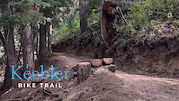
        open trail in app

        Download Trail

        Save to wishlist, Garmin & download.
        save the trail

        Find Related Routes

        Find routes and users activities that include this trail.
        find routes for this trail

        You must enter a description before submitting.