more stats
2.3 miles
Distance
54 ft
Climb
-1,113 ft
Descent
00:23:47
Avg time
-1,059 ft
Altitude change
1,861 ft
Altitude min
2,952 ft
Altitude max
2,922 ft
Altitude start
1,864 ft
Altitude end
-8.7%
Grade
-82.9%
Grade max
18.5%
Grade min
1,617 ft
Distance climb
2 miles
Distance down
656 ft
Distance flat
00:23:47
Avg time

Ken Burton Details

  • Activities
    • Mountain Bike
    • Hike
    • Trail Running
  • Riding Area
    Brown Mountain
    Altadena, California
  • Difficulty Rating
  • Voted Difficulty
    Blue (3 votes)
  • Local Popularity
    85 in Mountain Biking [+]
    • 75 in Trail Running
    • 70 in Hiking
  • Global Ranking
    #58849 in Mountain Biking [+]
    • #48771 in Trail Running
    • #61873 in Hiking
  • Trail Type
    Singletrack
  • Bike Type
    AM, XC
  • Direction
    Downhill Primary
    Popular Direction Shown
  • Climb Difficulty
    Blue
  • Physical Rating
    Moderate
  • Dogs Allowed
    Yes
  • eBike Allowed
  • TTFs on Trail
    Skinny
  • Ride in Rain
    Yes
  • Year Opened
    1991

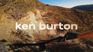
The Ken Burton trail in the Angeles National Forest is a milestone in Southern California mountain bike history. It represents the success of the local group Mount Wilson Bicycling Association (MWBA) and their strong, positive relationship with the USFS land managers in the 1990s. MWBA worked together with the USFS to build the trail as a memorial to Ken Burton, a loved Forestry Firefighter who left his friends and family much too soon.

The trail descends into the Arroyo Seco canyon from the top of Brown Mountain and connects to the Gabrielino trail. Rugged and exposed in many sections, the Ken Burton trail has over 20 steep switchbacks that challenge riders and keep you on your toes. The Ken Burton Monument is on your right side before the switchbacks start. The first three switchbacks will give you a good taste of what is coming ahead. As you near the bottom, be aware of the poison oak as it tends to flourish as you near the bottom of the canyon. Once you get to the Gabrielino, turn left and continue over the dam on your way back to the JPL area.

In 2009, the Station Fire destroyed the trail and it was closed for many years. In 2015, MWBA and CORBA volunteers joined forces and worked solidly for over 6 months on rebuilding the trail. On May 1st, 2016, the Ken Burton trail was officially re-opened at the MWBA Pancake Breakfast.

Access Info

Ken Burton is accessed by climbing 6 miles up Brown Mtn / Fern Truck trail from the JPL Windsor trailhead area

Trail Supporters

  • USFS
    Land Manager
Local Trail Association
Traditionally Indigenous Territory

Recent Activity on Trail

Past Week
  • 0 rides
  •  
6 Months
  • 11 rides
  • 18 miles avg distance
All
  • 78 rides
  • Last: May 30, 2026
c1c2c3c4
January
February
March
April
May
June
July
August
September
October
November
December
update trails status or condition

Ken Burton Trail Reports

statusdatedescription
Jul 26, 2025 @ 8:30am
Jul 26, 2025
The crew maintaining the trails are doing a solid job. It is in great shape for middle of July. Long sleeves are recommended as the brush is a...
May 3, 2025 @ 2:04pm
May 3, 2025
A tad overgrown, but rideable top to bottom. The switchbacks are in better shape, and more rideable, than I remember. Lots of Poison Oak toward...
Apr 30, 2025 @ 7:05pm
Apr 30, 2025
It’s very over grown; like a green tunnel, but other wise fine. There is a sketchy bit right when you get to the stream, but not a problem....
Mar 5, 2025 @ 9:00am
Mar 5, 2025
"Closed" area, because of fires. A friend who rode up to Brown Mt. and back down to El Prieto a couple of days ago said they have bulldozed a...
Mar 18, 2024 @ 4:41pm
Mar 18, 2024
a couple trees down that make you climb over. somewhat deep water crossings at the bottom at gabrielino.
more »
Status:
on Jul 26, 2025
Ideal
Avg: 3.77 (12 votes)
Your vote: 0

view (582)
close
3D
Trail Conditions
  • Unknown
  • Snow Groomed
  • Snow Packed
  • Snow Covered
  • Snow Cover Partial
  • Freeze/thaw Cycle
  • Icy
  • Prevalent Mud
  • Wet
  • Variable
  • Ideal
  • Dry
  • Very Dry
Trail Flow (Ridden Direction)
Trailforks scans users ridelogs to determine the most popular direction each trail is ridden. A good flowing trail network will have most trails flowing in a single direction according to their intension.
The colour categories are based on what percentage of riders are riding a trail in its intended direction.
  • > 96%
  • > 90%
  • > 80%
  • > 70%
  • > 50%
  • < 50%
  • bi-directional trail
  • no data
Trail Last Ridden
Trailforks scans ridelogs to determine the last time a trail was ridden.
  • < 2 days
  • < 1 week
  • < 2 weeks
  • < 1 month
  • < 6 months
  • > 6 months
Trail Ridden Direction
The intended direction a trail should be ridden.
  • Downhill Only
  • Downhill Primary
  • Both Directions
  • Uphill Primary
  • Uphill Only
  • One Direction
Contribute Details
Colors indicate trail is missing specified detail.
  • Description
  • Photos
  • Description & Photos
  • Videos
Trail Popularity ?
Trailforks scans ridelogs to determine which trails are ridden the most in the last 9 months. Trails are compared with nearby trails in the same city region with a possible 25 colour shades. Think of this as a heatmap, more rides = more kinetic energy = warmer colors.
  • most popular
  • popular
  • less popular
  • not popular
ATV/ORV/OHV Filter
Max Vehicle Width
inches
US Cell Coverage
Legend
cell carrier legend

Radar Time
Activity Recordings
Trailforks uses anonymized public activity data. ?
Activity Recordings
Trailforks uses anonymized public activity data. ?
Personal Heatmap
Activity Types
all / none
Options
2
Date range month
Winter Trails
Warning A routing network for winter maps does not exist. Selecting trails using the winter trails layer has been disabled.
Missing Trails
Most Popular
Least Popular
Trails are colored based on popularity. The more popular a trail is, the more red. Less popular trails trend towards green.
Jump Magnitude Heatmap
Heatmap of where riders jump on trails. Zoom in to see individual jumps, click circles to view jump details.
BC Backroad Status

Service Road Atlas is a free to use, community-driven service for viewing and creating reports on the numerous back-country service roads around B.C. and Alberta.

map legend
Slope Aspect
Direction the slope faces
Flat N NE E SE S SW W NW
Trails Deemphasized
Trails are shown in grey.
disable
Only show trails with no bike usage.
Enable
Suggested Layers
Based on selected activity type

    Save the current map location and zoom level as your default home location whenever this page is loaded.

    Save
        Directions to ken-burton trailhead (34.241880, -118.167420)

        Photos

        66 more »
        509 |
        Apr 18, 2016 @ 10:20am
        Apr 18, 2016
        535 |
        Apr 18, 2016 @ 10:21am
        Apr 18, 2016
        81 |
        Dec 31, 2023 @ 8:41am
        Dec 31, 2023
        80 |
        Dec 31, 2023 @ 8:40am
        Dec 31, 2023

        Videos

        6 more »
        Ken Burton - 08.29.21
        11:49 | 612 | Aug 29, 2021 , Altadena
        El Prieto
        3:44 | 287 | Apr 8, 2020 , Altadena
        Ken Burton Loop Angeles Crest Mountains (((MTB)))
        15:31 | 763 | Jun 11, 2019 , Altadena
        Ken Burton Trail with Martin - XC Mountain...
        27:50 | 634 | Apr 27, 2018 , Altadena

        Routes with this trail

        13 miles 2,362 ft 2 Loop
        Loop up and then keep climbing up brown mountain. Then loop around on the .
        8 miles 2,177 ft 2 Out & Back
        This is a trail in Alta Dena. Free parking is available on the street and the lower level of the JPL site....
        91 miles 20,077 ft 16
        Section 11 of the California to Canada trail, a long distance bikepacking route which connects trails from...

        10 Reviews & Comments


        We hope you've been enjoying Trailforks!

        Create a FREE account to view trail comments and much more.

        Frequently Asked Questions About Ken Burton

        Where is Ken Burton located?
        Ken Burton is located in Brown Mountain, Altadena, California, United States. It is part of the Brown Mountain trail network. The trailhead is located at coordinates 34.24188, -118.16742.
        How hard is Ken Burton?
        Ken Burton is rated as Blue difficulty. The physical rating is Moderate. The average grade is 8.7%. The climb difficulty is rated Blue.
        What is the elevation gain for Ken Burton?
        Ken Burton has 54 ft of elevation gain. The trail has 1,113 ft of elevation descent. The elevation ranges from 1,861 ft to 2,952 ft.
        Is Ken Burton a point to point trail?
        Ken Burton is not a point to point trail. The direction is Downhill Primary. The trail type is singletrack.

        Hit the Trail

        Open in App

        Get this trail on your phone instantly.
        open trail in app

        Download Trail

        Save to wishlist, Garmin & download.
        save the trail

        Find Related Routes

        Find routes and users activities that include this trail.
        find routes for this trail

        You must enter a description before submitting.