

Open in App
Get this trail on your phone instantly.

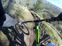
Almost all singletrack, this ride contours along oak-studded hillsides, in and out of several drainages, and up and down several ridges, paralleling the Kern River and Highway 178 for much of this route. Although it requires a shuttle ride-unlike most of the others in this chapter-is not a downhill ride. It is definitely more of a cross-country workout. Although there are no sustained climbs, there is a lot of short climbing involved. Because much of the route is exposed and is at lower elevations, it is best done in spring and fall. Summer can be very hot.
Lookout for snakes in the summer
Kern Canyon Trail is close to Lake Isabella and about 15 minutes south of Kernville.
From Keyesville: The Keyesville entrance is located just north of the town of Lake Isabella. From Hwy 155, go west on Keyesville Road. Drive almost .7 miles and park on the left in the large dirt open area near the restrooms. This is known at the main Keyesville Staging Area. Follow the directions to the Keyesville Classic, and turn RIGHT onto Kern Canyon Trail approximately 3.5 miles from the staging area.
Freeway Bridge Trailhead: The trailhead parking is on the north side of the 178 at Freeway Ridge 4X4 Road. Look for a dirt parking area with an unlocked gate about 3 miles southwest of of Borel Road or 4.5 miles northeast of the Delonegha Bridge.
From the parking area head up the 4x4 road for a couple hundred feet and turn left on the Kern Canyon Trail.
Delonegha Bridge Lower Trailhead: IF you are driving from Bakersfield, the Delonegha Bridge Parking area is 22 miles up canyon from the HWY 184/178 junction. After Hwy 178 widens into a 4-lane freeway, watch for the parking turnoff on the right just before the bridge. Park at the large parking area by the river. The trail is on the other side of the river, so you have to do a little scrambling and cross the bridge.


| c1 | c2 | c3 | c4 |
|---|---|---|---|
January | February | March | April |
May | June | July | August |
September | October | November | December |


Service Road Atlas is a free to use, community-driven service for viewing and creating reports on the numerous back-country service roads around B.C. and Alberta.
Save the current map location and zoom level as your default home location whenever this page is loaded.
SaveWe hope you've been enjoying Trailforks!
Create a FREE account to view trail comments and much more.
You must enter a description before submitting.

