more stats
1.8 miles
Distance
30 ft
Climb
-382 ft
Descent
00:14:05
Avg time
-351 ft
Altitude change
4,778 ft
Altitude min
5,131 ft
Altitude max
5,130 ft
Altitude start
4,780 ft
Altitude end
-3.7%
Grade
-36.3%
Grade max
10.3%
Grade min
906 ft
Distance climb
1 mile
Distance down
1,499 ft
Distance flat
00:14:05
Avg time

Kestrel Run Details

  • Activities
    • Mountain Bike
    • E-Bike
    • Hike
    • Trail Running
  • Riding Area
  • Difficulty Rating
  • Voted Difficulty
    Blue (1 vote)
  • Local Popularity
    100 in Mountain Biking [+]
    • 80 in Trail Running
    • 90 in Hiking
  • Global Ranking
    #1132 in Mountain Biking [+]
    • #61562 in Trail Running
    • #3801 in Hiking
  • Hiking SAC Scale
    T2 Mountain Hiking
  • Trail Exposure
    Normal
  • Trail Type
    Singletrack
  • Bike Type
    AM, XC
  • Direction
    Both Directions[+]
    Popular Direction Shown
    • Both Directions for E-Biking
    • Both Directions for Trail Running
    • Both Directions for Hiking
  • Climb Difficulty
    Blue
  • Physical Rating
    Moderate
  • Trail Visibility
    Always easy to follow
  • Season
    March - October
  • Dogs Allowed
    Yes
  • eBike Allowed
    Yes up to Class 1
  • TTFs on Trail
    Rock Face, Rock Garden
  • Lighting
    No
  • Year Opened
    2023
  • Land Owner
    BLM

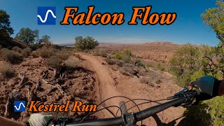
The final singletrack segment of the Raptor Route. This two-way trail branches off Falcon Flow before the parking lot and brings you further down Sand Flats Rd. to Hawk Campground. The trail crosses Sand Flats Rd. about half way through. A mix of some nice flow and challenging features. Be aware of the advanced "Kestrel Fin" on your way up or down
The trail is new and fairly sandy, but will pack in as it ages.

Access Info

Splits from Falcon Flow a few hundred yards from the bottom parking lot.
In the back of "Hawk" Campground

Disclaimer

Moderate trail with advanced features.

Local Trail Association
Traditionally Indigenous Territory

Recent Activity on Trail

Past Week
  • 3 rides
  • 22 miles average
6 Months
  • 344 rides
  • 16 miles avg distance
All
  • 1,245 rides
  • Last: Jun 13, 2026
c1c2c3c4
January
February
March
April
May
June
July
August
September
October
November
December
Status:
on May 19, 2026
Ideal
Avg: 4.35 (16 votes)
Your vote: 0

view (4,533)
close
3D
Trail Conditions
  • Unknown
  • Snow Groomed
  • Snow Packed
  • Snow Covered
  • Snow Cover Partial
  • Freeze/thaw Cycle
  • Icy
  • Prevalent Mud
  • Wet
  • Variable
  • Ideal
  • Dry
  • Very Dry
Trail Flow (Ridden Direction)
Trailforks scans users ridelogs to determine the most popular direction each trail is ridden. A good flowing trail network will have most trails flowing in a single direction according to their intension.
The colour categories are based on what percentage of riders are riding a trail in its intended direction.
  • > 96%
  • > 90%
  • > 80%
  • > 70%
  • > 50%
  • < 50%
  • bi-directional trail
  • no data
Trail Last Ridden
Trailforks scans ridelogs to determine the last time a trail was ridden.
  • < 2 days
  • < 1 week
  • < 2 weeks
  • < 1 month
  • < 6 months
  • > 6 months
Trail Ridden Direction
The intended direction a trail should be ridden.
  • Downhill Only
  • Downhill Primary
  • Both Directions
  • Uphill Primary
  • Uphill Only
  • One Direction
Contribute Details
Colors indicate trail is missing specified detail.
  • Description
  • Photos
  • Description & Photos
  • Videos
Trail Popularity ?
Trailforks scans ridelogs to determine which trails are ridden the most in the last 9 months. Trails are compared with nearby trails in the same city region with a possible 25 colour shades. Think of this as a heatmap, more rides = more kinetic energy = warmer colors.
  • most popular
  • popular
  • less popular
  • not popular
ATV/ORV/OHV Filter
Max Vehicle Width
inches
US Cell Coverage
Legend
cell carrier legend

Radar Time
Activity Recordings
Trailforks uses anonymized public activity data. ?
Activity Recordings
Trailforks uses anonymized public activity data. ?
Personal Heatmap
Activity Types
all / none
Options
2
Date range month
Winter Trails
Warning A routing network for winter maps does not exist. Selecting trails using the winter trails layer has been disabled.
Missing Trails
Most Popular
Least Popular
Trails are colored based on popularity. The more popular a trail is, the more red. Less popular trails trend towards green.
Jump Magnitude Heatmap
Heatmap of where riders jump on trails. Zoom in to see individual jumps, click circles to view jump details.
BC Backroad Status

Service Road Atlas is a free to use, community-driven service for viewing and creating reports on the numerous back-country service roads around B.C. and Alberta.

map legend
Slope Aspect
Direction the slope faces
Flat N NE E SE S SW W NW
Trails Deemphasized
Trails are shown in grey.
disable
Only show trails with no bike usage.
Enable
Suggested Layers
Based on selected activity type

    Save the current map location and zoom level as your default home location whenever this page is loaded.

    Save
        Directions to kestrel-run trailhead (38.579710, -109.464730)

        Photos

        31 more »
        55 |
        Apr 16, 2026 @ 7:44am
        Apr 16, 2026
        160 |
        Aug 30, 2024 @ 3:58pm
        Aug 30, 2024
        133 |
        Aug 30, 2024 @ 3:58pm
        Aug 30, 2024
        144 |
        Aug 30, 2024 @ 3:57pm
        Aug 30, 2024

        Videos

        3 more »
        youtuber Falcon Flow and Kestrel Run
        14:35 | 210 | Jan 10, 2025 , Moab
        Kestrel Run - Moab, UT
        10:49 | 209 | Dec 5, 2024 , Moab
        Kestrel Run MTB Trail Moab Utah
        8:48 | 310 | Mar 8, 2024 , Moab

        Routes with this trail

        4.2 11 miles 436 ft 4 Loop
        Update of route to add the new trail. , , , , or the Raptor Route is an excellent downhill route that is...
        5.0 27 miles 1,486 ft 13 Shuttled
        This is the whole enchilada /w , but instead of LPS, you take the raptor route! Slightly more intermediate...
        19 miles 2,951 ft 4 Loop
        Normal Raptor Route with the road climb added in.

        7 Reviews & Comments


        We hope you've been enjoying Trailforks!

        Create a FREE account to view trail comments and much more.

        • By GrandCountyTrailsTF Pro MTM & contributors
        • #710907 - 3,433 views

        Frequently Asked Questions About Kestrel Run

        Where is Kestrel Run located?
        Kestrel Run is located in Sand Flats Recreation Area, Moab, Utah, United States. It is part of the Sand Flats Recreation Area trail network. The trailhead is located at coordinates 38.57971, -109.46473.
        How hard is Kestrel Run?
        Kestrel Run is rated as Blue difficulty. The physical rating is Moderate. The average grade is 3.7%. The climb difficulty is rated Blue.
        What is the elevation gain for Kestrel Run?
        Kestrel Run has 30 ft of elevation gain. The trail has 382 ft of elevation descent. The elevation ranges from 4,778 ft to 5,131 ft.
        Is Kestrel Run a point to point trail?
        Kestrel Run is not a point to point trail. The direction is Both Directions. The trail type is singletrack.

        Hit the Trail

        Open in App

        Get this trail on your phone instantly.
        open trail in app

        Download Trail

        Save to wishlist, Garmin & download.
        save the trail

        Find Related Routes

        Find routes and users activities that include this trail.
        find routes for this trail

        You must enter a description before submitting.