more stats
2.6 miles
Distance
532 ft
Climb
-88 ft
Descent
00:17:20
Avg time
444 ft
Altitude change
8,561 ft
Altitude min
9,006 ft
Altitude max
8,561 ft
Altitude start
9,006 ft
Altitude end
3.2%
Grade
-18.7%
Grade max
34.9%
Grade min
2 miles
Distance climb
3,658 ft
Distance down
965 ft
Distance flat
00:17:20
Avg time

Keystone Details

  • Activities
    • Mountain Bike
    • Adaptive Bike
    • Hike
    • Trail Running
  • Riding Area
    Park City Mountain Resort
    Park City, Utah
  • Difficulty Rating
  • Voted Difficulty
    Blue (1 vote)
  • Local Popularity
    15 in Mountain Biking [+]
    • 5 in Trail Running
    • 20 in Hiking
  • Global Ranking
    #115494 in Mountain Biking [+]
    • #216508 in Trail Running
    • #121536 in Hiking
  • Hiking SAC Scale
    T2 Mountain Hiking
  • Trail Type
    Singletrack
  • Bike Type
    AM, XC, Adaptive MTB
  • Direction
    Both Directions
  • Dogs Allowed
    Yes

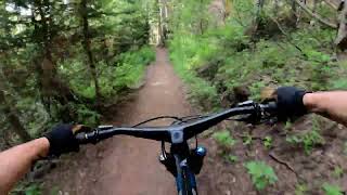
Excellent flow, even some little rock drop jumps. You need to pedal but you can get moving pretty fast in either direction.

Adaptive Bike Info
aMTB Blue Rating: Intermediate features and steeper terrain.

Trail width 24 - 36” wide. Very little technical difficulty, velvet smooth, tread. It gets very narrow as it crosses Thanes ski run. Some narrow points between rocks and trees as well

Local Trail Association
Traditionally Indigenous Territory

Recent Activity on Trail

Past Week
  • 0 rides
  •  
6 Months
  • 0 rides
  •  
All
  • 108 rides
  • Last: Sep 8, 2025
c1c2c3c4
January
February
March
April
May
June
July
August
September
October
November
December
update trails status or condition

Keystone Trail Reports

statusdatedescription
Jun 12, 2026 @ 4:12pm (America/Denver)
Jun 12, 2026
Tree from last post is gone, trail is pretty solid right now
Jun 3, 2026 @ 3:43pm (America/Denver)
Jun 3, 2026
Blow Down Turned Around. Just beyond Apex junctions a couple trees are on trail. Please don't do the hike around which ruins the forest.
Aug 31, 2025 @ 2:31pm
Aug 31, 2025
Bone dry but not loose yet after the rain this week
Jul 5, 2025 @ 8:21am
Jul 5, 2025
The tree that was down has been cleared. Good to go!
Jun 28, 2025 @ 9:35am
Jun 28, 2025
Huge aspen still down near Hoist run,40.62187,-111.53926
more »
Status:
on Jun 12, 2026
Ideal
Avg: 4.28 (19 votes)
Your vote: 0

view (3,837)
close
3D
Trail Conditions
  • Unknown
  • Snow Groomed
  • Snow Packed
  • Snow Covered
  • Snow Cover Partial
  • Freeze/thaw Cycle
  • Icy
  • Prevalent Mud
  • Wet
  • Variable
  • Ideal
  • Dry
  • Very Dry
Trail Flow (Ridden Direction)
Trailforks scans users ridelogs to determine the most popular direction each trail is ridden. A good flowing trail network will have most trails flowing in a single direction according to their intension.
The colour categories are based on what percentage of riders are riding a trail in its intended direction.
  • > 96%
  • > 90%
  • > 80%
  • > 70%
  • > 50%
  • < 50%
  • bi-directional trail
  • no data
Trail Last Ridden
Trailforks scans ridelogs to determine the last time a trail was ridden.
  • < 2 days
  • < 1 week
  • < 2 weeks
  • < 1 month
  • < 6 months
  • > 6 months
Trail Ridden Direction
The intended direction a trail should be ridden.
  • Downhill Only
  • Downhill Primary
  • Both Directions
  • Uphill Primary
  • Uphill Only
  • One Direction
Contribute Details
Colors indicate trail is missing specified detail.
  • Description
  • Photos
  • Description & Photos
  • Videos
Trail Popularity ?
Trailforks scans ridelogs to determine which trails are ridden the most in the last 9 months. Trails are compared with nearby trails in the same city region with a possible 25 colour shades. Think of this as a heatmap, more rides = more kinetic energy = warmer colors.
  • most popular
  • popular
  • less popular
  • not popular
ATV/ORV/OHV Filter
Max Vehicle Width
inches
US Cell Coverage
Legend
cell carrier legend

Radar Time
Activity Recordings
Trailforks uses anonymized public activity data. ?
Activity Recordings
Trailforks uses anonymized public activity data. ?
Personal Heatmap
Activity Types
all / none
Options
2
Date range month
Winter Trails
Warning A routing network for winter maps does not exist. Selecting trails using the winter trails layer has been disabled.
Missing Trails
Most Popular
Least Popular
Trails are colored based on popularity. The more popular a trail is, the more red. Less popular trails trend towards green.
Jump Magnitude Heatmap
Heatmap of where riders jump on trails. Zoom in to see individual jumps, click circles to view jump details.
BC Backroad Status

Service Road Atlas is a free to use, community-driven service for viewing and creating reports on the numerous back-country service roads around B.C. and Alberta.

map legend
Slope Aspect
Direction the slope faces
Flat N NE E SE S SW W NW
Trails Deemphasized
Trails are shown in grey.
disable
Only show trails with no bike usage.
Enable
Suggested Layers
Based on selected activity type

    Save the current map location and zoom level as your default home location whenever this page is loaded.

    Save
        Directions to keystone-11691 trailhead (40.626180, -111.520160)

        Photos

        30 more »
        41 |
        Jul 21, 2024 @ 8:49am
        Jul 21, 2024
        23 |
        Oct 8, 2023 @ 6:41am
        Oct 8, 2023
        47 |
        Sep 27, 2023 @ 5:47pm
        Sep 27, 2023
        44 |
        Jul 19, 2023 @ 11:18am
        Jul 19, 2023

        Videos

        2 more »
        Keystone // Powerlines // Spiro 4K POV Park...
        25:23 | 236 | Aug 21, 2022 , Park City
        Keystone Flow
        0:24 | 336 | Sep 29, 2014 , Park City

        Routes with this trail

        5.0 19 miles 3,047 ft 42 Loop
        Unique ascent up Flat Cable to Jenni's, John's and Keystone
        4.0 18 miles 3,144 ft 29
        Big climb to big descent. Should be fun
        4.0 23 miles 3,830 ft 26 Point to Point
        Park City to Canyons via Wasatch Crest

        2 Reviews & Comments


        We hope you've been enjoying Trailforks!

        Create a FREE account to view trail comments and much more.

        • By toddTF Pro Trailforks & contributors
        • #11691 - 4,556 views

        Frequently Asked Questions About Keystone

        Where is Keystone located?
        Keystone is located in Park City Mountain Resort, Park City, Utah, United States. It is part of the Park City Mountain Resort trail network. The trailhead is located at coordinates 40.62618, -111.52016.
        How hard is Keystone?
        Keystone is rated as Blue difficulty. The average grade is 3.2%.
        What is the elevation gain for Keystone?
        Keystone has 532 ft of elevation gain. The trail has 88 ft of elevation descent. The elevation ranges from 8,561 ft to 9,006 ft.
        Is Keystone a point to point trail?
        Keystone is not a point to point trail. The direction is Both Directions. The trail type is singletrack.

        Hit the Trail

        Open in App

        Get this trail on your phone instantly.
        open trail in app

        Download Trail

        Save to wishlist, Garmin & download.
        save the trail

        Find Related Routes

        Find routes and users activities that include this trail.
        find routes for this trail

        You must enter a description before submitting.