more stats
1.9 miles
Distance
26 ft
Climb
-1,320 ft
Descent
00:24:58
Avg time
-1,295 ft
Altitude change
4,614 ft
Altitude min
5,909 ft
Altitude max
5,909 ft
Altitude start
4,613 ft
Altitude end
-13.2%
Grade
-56.8%
Grade max
14.2%
Grade min
495 ft
Distance climb
2 miles
Distance down
338 ft
Distance flat
00:24:58
Avg time

Khyber Pass Details

  • Activities
    • Mountain Bike
    • Hike
    • Trail Running
  • Riding Area
    Whistler South CRA
    Whistler, British Columbia
  • Difficulty Rating
  • Voted Difficulty
    Black Diamond (3 votes)
  • Local Popularity
    55 in Mountain Biking [+]
    • 20 in Trail Running
    • 40 in Hiking
  • Global Ranking
    #45383 in Mountain Biking [+]
    • #64060 in Trail Running
    • #117191 in Hiking
  • Hiking SAC Scale
    T2 Mountain Hiking
  • Trail Type
    Singletrack
  • Bike Type
    DH, AM
  • Direction
    Downhill Primary
    Popular Direction Shown
  • Climb Difficulty
    Black Diamond
  • Physical Rating
    Hard
  • Trail Visibility
    Always easy to follow
  • Season
    July - September
  • Dogs Allowed
    Yes

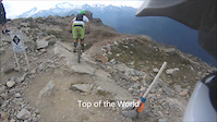
Combines the best of trail riding (fun trail, good flow, variety of trail, etc) with the best of park riding (the chair lift does all the hard work). Khyber is best ridden on an all mountain/enduro type bike (eg a 6 & 6 type bike) and best accessed via Top Of The World from the top of the Peak Chair. The trail isn't as steep as other options such as Ride Don't Slide or Kashmir, and instead traverses through the subalpine and deep forest of the upper flanks of Whistler Mountain above Creekside and Function Junction. It is comparable in difficulty to the first half of Top Of The World.

Near the end of Khyber, there are a few options to pick from - Middle Of Nowhere (leads to Kashmir & Kush), Upper Babylon By Bike (leads to questioning your life's decisions), or lots of logging road down to lower trails (leads to options such as See Colours and Puke, Heavy Flow, Tunnel Vision, Big Timber)

Note: bikers thinking of riding Khyber need to realize that they're no longer in the bike park and need to be self-sufficient for any potential repairs or injuries. Bring lots of water and snacks if you haven't ridden it before, as it can take you a while to get back down to the valley.

Access Info

Via Top Of The World

Local Trail Association

Recent Activity on Trail

Past Week
  • 0 rides
  •  
6 Months
  • 0 rides
  •  
All
  • 250 rides
  • Last: Jun 8, 2023
c1c2c3c4
January
February
March
April
May
June
July
August
September
October
November
December
update trails status or condition

Khyber Pass Trail Reports

Status:
on Oct 20, 2025
Avg: 4.31 (39 votes)
Your vote: 0

view (1,669)
close
3D
Trail Conditions
  • Unknown
  • Snow Groomed
  • Snow Packed
  • Snow Covered
  • Snow Cover Partial
  • Freeze/thaw Cycle
  • Icy
  • Prevalent Mud
  • Wet
  • Variable
  • Ideal
  • Dry
  • Very Dry
Trail Flow (Ridden Direction)
Trailforks scans users ridelogs to determine the most popular direction each trail is ridden. A good flowing trail network will have most trails flowing in a single direction according to their intension.
The colour categories are based on what percentage of riders are riding a trail in its intended direction.
  • > 96%
  • > 90%
  • > 80%
  • > 70%
  • > 50%
  • < 50%
  • bi-directional trail
  • no data
Trail Last Ridden
Trailforks scans ridelogs to determine the last time a trail was ridden.
  • < 2 days
  • < 1 week
  • < 2 weeks
  • < 1 month
  • < 6 months
  • > 6 months
Trail Ridden Direction
The intended direction a trail should be ridden.
  • Downhill Only
  • Downhill Primary
  • Both Directions
  • Uphill Primary
  • Uphill Only
  • One Direction
Contribute Details
Colors indicate trail is missing specified detail.
  • Description
  • Photos
  • Description & Photos
  • Videos
Trail Popularity ?
Trailforks scans ridelogs to determine which trails are ridden the most in the last 9 months. Trails are compared with nearby trails in the same city region with a possible 25 colour shades. Think of this as a heatmap, more rides = more kinetic energy = warmer colors.
  • most popular
  • popular
  • less popular
  • not popular
ATV/ORV/OHV Filter
Max Vehicle Width
inches
US Cell Coverage
Legend
cell carrier legend

Radar Time
Activity Recordings
Trailforks uses anonymized public activity data. ?
Activity Recordings
Trailforks uses anonymized public activity data. ?
Personal Heatmap
Activity Types
all / none
Options
2
Date range month
Winter Trails
Warning A routing network for winter maps does not exist. Selecting trails using the winter trails layer has been disabled.
Missing Trails
Most Popular
Least Popular
Trails are colored based on popularity. The more popular a trail is, the more red. Less popular trails trend towards green.
Jump Magnitude Heatmap
Heatmap of where riders jump on trails. Zoom in to see individual jumps, click circles to view jump details.
BC Backroad Status

Service Road Atlas is a free to use, community-driven service for viewing and creating reports on the numerous back-country service roads around B.C. and Alberta.

map legend
Slope Aspect
Direction the slope faces
Flat N NE E SE S SW W NW
Trails Deemphasized
Trails are shown in grey.
disable
Only show trails with no bike usage.
Enable
Suggested Layers
Based on selected activity type

    Save the current map location and zoom level as your default home location whenever this page is loaded.

    Save
        Directions to khyber-pass trailhead (50.058870, -122.976400)

        Photos

        62 more »
        869 |
        Sep 18, 2017 @ 8:51am
        Sep 18, 2017
        6,589 |
        Oct 14, 2015 @ 12:01am
        Oct 14, 2015
        34 |
        Sep 11, 2025 @ 5:38pm
        Sep 11, 2025
        40 |
        Sep 11, 2025 @ 5:38pm
        Sep 11, 2025

        Videos

        7 more »
        Massive Lap Down Top Of The World To Khyber...
        40:01 | 516 | Sep 13, 2021 , Whistler
        youtuber Mountain Biking: Khyber Pass to Middle of...
        12:28 | 989 | Jan 24, 2020 , Whistler
        Epic MTB Descent in Whistler-Top Of The World,...
        797 | Sep 3, 2017 , Whistler
        Whistler, Top to bottom
        9:00 | 1043 | Oct 18, 2014 , Whistler

        Routes with this trail

        5.0 8 miles 199 ft 12 Shuttled
        This is one of the best gravity laps you can possibly do in Whistler and is the next best thing you can do...
        5.0 7 miles 215 ft 9 Point to Point
        Maybe the best collection of technical singletrack descending in the entire Whistler valley, from the top...
        3.3 64 miles 16,935 ft 39
        Wait for any of the longer days in Summer and look to complete the 4 corners of Whistler - Top of the...

        Trail Products

        3 Reviews & Comments


        We hope you've been enjoying Trailforks!

        Create a FREE account to view trail comments and much more.

        • By canadakaTF Pro Trailforks & contributors
        • #3249 - 20,347 views

        Frequently Asked Questions About Khyber Pass

        Where is Khyber Pass located?
        Khyber Pass is located in Whistler South CRA, Whistler, British Columbia, Canada. It is part of the Whistler South CRA trail network. The trailhead is located at coordinates 50.05887, -122.9764.
        How hard is Khyber Pass?
        Khyber Pass is rated as Black Diamond difficulty. The physical rating is Hard. The average grade is 13.2%. The climb difficulty is rated Black Diamond.
        What is the elevation gain for Khyber Pass?
        Khyber Pass has 8 m of elevation gain. The trail has 402 m of elevation descent. The elevation ranges from 1,406 m to 1,801 m.
        Is Khyber Pass a point to point trail?
        Khyber Pass is not a point to point trail. The direction is Downhill Primary. The trail type is singletrack.

        Hit the Trail

        Open in App

        Get this trail on your phone instantly.
        open trail in app

        Download Trail

        Save to wishlist, Garmin & download.
        save the trail

        Find Related Routes

        Find routes and users activities that include this trail.
        find routes for this trail

        You must enter a description before submitting.