more stats
3,698 ft
Distance
-261 ft
Descent
00:02:52
Avg time
-262 ft
Altitude change
1,241 ft
Altitude min
1,504 ft
Altitude max
1,504 ft
Altitude start
1,240 ft
Altitude end
-7.1%
Grade
-29.8%
Grade max
1.6%
Grade min
85 ft
Distance climb
3,192 ft
Distance down
305 ft
Distance flat
00:02:52
Avg time

Klipwerf Details

  • Activities
    • Mountain Bike
    • E-Bike
    • Winter Fat Bike
    • Hike
    • Trail Running
  • Riding Area
    Bethlehem Plaas
    Stellenbosch
  • Ref Number
    BC28
  • AKA
    Niknaks descent
  • Difficulty Rating
  • Local Popularity
    100 in Mountain Biking [+]
    • 100 in E-Biking
    • 65 in Trail Running
    • 65 in Hiking
  • Global Ranking
    #29266 in Mountain Biking [+]
    • #3841 in E-Biking
    • #91428 in Trail Running
    • #89866 in Hiking
  • Hiking SAC Scale
    T1 Hiking
  • Trail Type
    Singletrack
  • Bike Type
    DH, AM, XC, DJ, Fat
  • Direction
    Downhill Only
    Popular Direction Shown
  • Climb Difficulty
    Blue
  • Physical Rating
    Moderate
  • Trail Visibility
    Always easy to follow
  • Season
    all year
  • eBike Allowed
    Yes up to Class 1
  • TTFs on Trail
    Berm, Bridge, Drop, Jump, Rock Garden, Wallride
  • Year Opened
    2018
  • Land Owner
    Bethlehem Plaas

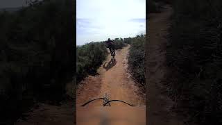
Flowing fast descent off Niknaks and Old Bethlehem Sky Traverse. Awesome features.

Access Info

Permits available on Banhoek Conservancy website or QR code or Boschendal Trail Centre

Trail Supporters
  • Old Bethlehem Trail team
    since 2
    Maintainer

Recent Activity on Trail

Past Week
  • 2 rides
  • 25 miles average
6 Months
  • 147 rides
  • 25 miles avg distance
All
  • 623 rides
  • Last: Jun 21, 2026
c1c2c3c4
January
February
March
April
May
June
July
August
September
October
November
December
update trails status or condition

Klipwerf Trail Reports

statusdatedescription
Jun 16, 2026 @ 11:05am (Africa/Maseru)
Jun 16, 2026
Oct 18, 2025 @ 12:24pm (Africa/Johannesburg)
Oct 18, 2025
pristine condition...PB time
Jul 13, 2025 @ 9:38am
Jul 13, 2025
Jan 4, 2025 @ 7:38am
Jan 4, 2025
Quite a few more brake bumps than usual, but it is expected mid-summer in the Winelands area
Dec 27, 2024 @ 6:27am
Dec 27, 2024
Loved this well maintained trail
more »
Status:
on Jun 16, 2026
Ideal
Avg: 4.29 (4 votes)
Your vote: 0

view (5,500)
close
3D
Trail Conditions
  • Unknown
  • Snow Groomed
  • Snow Packed
  • Snow Covered
  • Snow Cover Partial
  • Freeze/thaw Cycle
  • Icy
  • Prevalent Mud
  • Wet
  • Variable
  • Ideal
  • Dry
  • Very Dry
Trail Flow (Ridden Direction)
Trailforks scans users ridelogs to determine the most popular direction each trail is ridden. A good flowing trail network will have most trails flowing in a single direction according to their intension.
The colour categories are based on what percentage of riders are riding a trail in its intended direction.
  • > 96%
  • > 90%
  • > 80%
  • > 70%
  • > 50%
  • < 50%
  • bi-directional trail
  • no data
Trail Last Ridden
Trailforks scans ridelogs to determine the last time a trail was ridden.
  • < 2 days
  • < 1 week
  • < 2 weeks
  • < 1 month
  • < 6 months
  • > 6 months
Trail Ridden Direction
The intended direction a trail should be ridden.
  • Downhill Only
  • Downhill Primary
  • Both Directions
  • Uphill Primary
  • Uphill Only
  • One Direction
Contribute Details
Colors indicate trail is missing specified detail.
  • Description
  • Photos
  • Description & Photos
  • Videos
Trail Popularity ?
Trailforks scans ridelogs to determine which trails are ridden the most in the last 9 months. Trails are compared with nearby trails in the same city region with a possible 25 colour shades. Think of this as a heatmap, more rides = more kinetic energy = warmer colors.
  • most popular
  • popular
  • less popular
  • not popular
ATV/ORV/OHV Filter
Max Vehicle Width
inches
US Cell Coverage
Legend
cell carrier legend

Radar Time
Activity Recordings
Trailforks uses anonymized public activity data. ?
Activity Recordings
Trailforks uses anonymized public activity data. ?
Personal Heatmap
Activity Types
all / none
Options
2
Date range month
Winter Trails
Warning A routing network for winter maps does not exist. Selecting trails using the winter trails layer has been disabled.
Missing Trails
Most Popular
Least Popular
Trails are colored based on popularity. The more popular a trail is, the more red. Less popular trails trend towards green.
Jump Magnitude Heatmap
Heatmap of where riders jump on trails. Zoom in to see individual jumps, click circles to view jump details.
BC Backroad Status

Service Road Atlas is a free to use, community-driven service for viewing and creating reports on the numerous back-country service roads around B.C. and Alberta.

map legend
Slope Aspect
Direction the slope faces
Flat N NE E SE S SW W NW
Trails Deemphasized
Trails are shown in grey.
disable
Only show trails with no bike usage.
Enable
Suggested Layers
Based on selected activity type

    Save the current map location and zoom level as your default home location whenever this page is loaded.

    Save
        Directions to klipwerf trailhead (-33.930790, 18.966360)

        Photos

        9 more »
        67 |
        Oct 21, 2022 @ 9:10pm
        Oct 21, 2022
        62 |
        Oct 21, 2022 @ 9:10pm
        Oct 21, 2022
        82 |
        Oct 21, 2022 @ 9:10pm
        Oct 21, 2022
        108 |
        Jun 22, 2021 @ 8:51am
        Jun 22, 2021

        Videos

        6 more »
        youtuber Itchy face...
        0:08 | 141 | Oct 6, 2023 , Stellenbosch
        youtuber The most famous trail in South Africa
        0:56 | 133 | Oct 5, 2023 , Stellenbosch
        youtuber It was heartbreaking to crash like that.
        0:18 | 113 | Oct 3, 2023 , Stellenbosch
        youtuber I hope to see African animals. #shorts #mtb
        0:34 | 175 | Sep 27, 2023 , Stellenbosch

        Routes with this trail

        11 miles 1,217 ft 9 Loop
        Don’t be fooled by the distance — this route still includes a tough climb and several technical...
        24 miles 3,888 ft 24 Loop
        This one’s a monster. Expect exposed ridgelines, steep climbing, rocky descents, and serious elevation...
        17 miles 2,311 ft 17 Loop
        This route introduces Goddess — a mountainside singletrack with massive views and proper exposure. A...

        2 Reviews & Comments


        We hope you've been enjoying Trailforks!

        Create a FREE account to view trail comments and much more.

        Frequently Asked Questions About Klipwerf

        Where is Klipwerf located?
        Klipwerf is located in Bethlehem Plaas, Stellenbosch, South Africa. It is part of the Bethlehem Plaas trail network. The trailhead is located at coordinates -33.93079, 18.96636.
        How hard is Klipwerf?
        Klipwerf is rated as Blue difficulty. The physical rating is Moderate. The average grade is 7.1%. The climb difficulty is rated Blue.
        What is the elevation gain for Klipwerf?
        The trail has 261 ft of elevation descent. The elevation ranges from 1,241 ft to 1,504 ft.
        Is Klipwerf a point to point trail?
        Yes, Klipwerf is a point to point trail. The direction is Downhill Only. The trail type is singletrack.

        Hit the Trail

        Open in App

        Get this trail on your phone instantly.
        open trail in app

        Download Trail

        Save to wishlist, Garmin & download.
        save the trail

        Find Related Routes

        Find routes and users activities that include this trail.
        find routes for this trail

        You must enter a description before submitting.