more stats
3,481 ft
Distance
18 ft
Climb
-67 ft
Descent
00:03:23
Avg time
-47 ft
Altitude change
253 ft
Altitude min
313 ft
Altitude max
313 ft
Altitude start
266 ft
Altitude end
-1.3%
Grade
-9.7%
Grade max
8.4%
Grade min
571 ft
Distance climb
2,024 ft
Distance down
886 ft
Distance flat
00:03:23
Avg time

Koala Details

  • Activities
    • Mountain Bike
    • E-Bike
    • Gravel Bike
    • Adaptive Bike
    • Winter Fat Bike
    • Horse
    • Hike
    • Trail Running
  • Riding Area
    Daisy Hill
    Brisbane
  • Ref Number
    #5
  • Difficulty Rating
  • Voted Difficulty
    Blue (1 vote)
  • Local Popularity
    100 in Mountain Biking [+]
    • 100 in E-Biking
    • 55 in Trail Running
    • 80 in Hiking
    • 5 in Horseback
  • Global Ranking
    #60 in Mountain Biking [+]
    • #1794 in E-Biking
    • #60782 in Trail Running
    • #36910 in Hiking
    • #981 in Horseback
  • Trail Type
    Singletrack
  • Bike Type
    AM, XC, Fat, Adaptive MTB, CX, Gravel
  • Direction
    Both Directions
    Popular Direction Shown
  • Climb Difficulty
    Green
  • Physical Rating
    Easy
  • Trail Visibility
    Always easy to follow
  • Season
    All year round
  • eBike Allowed
    Yes up to Class 1
  • TTFs on Trail
    Berm, Jump, Other
  • Land Owner
    LCC

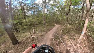
The trail flows nicely from Chipline/Tunnel of Love and is an easy trail with only one slightly rocky gentle descent. A popular trail at Daisy Hill as it helps connect riders from Chipline to Ripley's and beyond. A couple of nice berms will allow beginners to improve their cornering skills.

The land manager has a blue rating for the trail, but the trail currently runs as a green

Access Info

Open public access all year round although this trail network is best not ridden after solid rains as the soil type causes the trail to be easily damaged when wet.

Adaptive Bike Info
aMTB Blue Rating: Intermediate features and steeper terrain.

One log obsacle near the bottom which you may bottom out on

Local Trail Association
Traditionally Indigenous Territory

Recent Activity on Trail

Past Week
  • 28 rides
  • 18 miles average
6 Months
  • 547 rides
  • 14 miles avg distance
All
  • 7,573 rides
  • Last: Jun 20, 2026
c1c2c3c4
January
February
March
April
May
June
July
August
September
October
November
December
Status:
on Jun 20, 2026
Ideal
Avg: 4 (20 votes)
Your vote: 0

view (41,264)
close
3D
Trail Conditions
  • Unknown
  • Snow Groomed
  • Snow Packed
  • Snow Covered
  • Snow Cover Partial
  • Freeze/thaw Cycle
  • Icy
  • Prevalent Mud
  • Wet
  • Variable
  • Ideal
  • Dry
  • Very Dry
Trail Flow (Ridden Direction)
Trailforks scans users ridelogs to determine the most popular direction each trail is ridden. A good flowing trail network will have most trails flowing in a single direction according to their intension.
The colour categories are based on what percentage of riders are riding a trail in its intended direction.
  • > 96%
  • > 90%
  • > 80%
  • > 70%
  • > 50%
  • < 50%
  • bi-directional trail
  • no data
Trail Last Ridden
Trailforks scans ridelogs to determine the last time a trail was ridden.
  • < 2 days
  • < 1 week
  • < 2 weeks
  • < 1 month
  • < 6 months
  • > 6 months
Trail Ridden Direction
The intended direction a trail should be ridden.
  • Downhill Only
  • Downhill Primary
  • Both Directions
  • Uphill Primary
  • Uphill Only
  • One Direction
Contribute Details
Colors indicate trail is missing specified detail.
  • Description
  • Photos
  • Description & Photos
  • Videos
Trail Popularity ?
Trailforks scans ridelogs to determine which trails are ridden the most in the last 9 months. Trails are compared with nearby trails in the same city region with a possible 25 colour shades. Think of this as a heatmap, more rides = more kinetic energy = warmer colors.
  • most popular
  • popular
  • less popular
  • not popular
ATV/ORV/OHV Filter
Max Vehicle Width
inches
US Cell Coverage
Legend
cell carrier legend

Radar Time
Activity Recordings
Trailforks uses anonymized public activity data. ?
Activity Recordings
Trailforks uses anonymized public activity data. ?
Personal Heatmap
Activity Types
all / none
Options
2
Date range month
Winter Trails
Warning A routing network for winter maps does not exist. Selecting trails using the winter trails layer has been disabled.
Missing Trails
Most Popular
Least Popular
Trails are colored based on popularity. The more popular a trail is, the more red. Less popular trails trend towards green.
Jump Magnitude Heatmap
Heatmap of where riders jump on trails. Zoom in to see individual jumps, click circles to view jump details.
BC Backroad Status

Service Road Atlas is a free to use, community-driven service for viewing and creating reports on the numerous back-country service roads around B.C. and Alberta.

map legend
Slope Aspect
Direction the slope faces
Flat N NE E SE S SW W NW
Trails Deemphasized
Trails are shown in grey.
disable
Only show trails with no bike usage.
Enable
Suggested Layers
Based on selected activity type

    Save the current map location and zoom level as your default home location whenever this page is loaded.

    Save
        Directions to koala-46959 trailhead (-27.612980, 153.162630)

        Photos

        4 more »
        205 |
        Apr 28, 2018 @ 2:00am
        Apr 28, 2018
        145 |
        Apr 28, 2018 @ 2:00am
        Apr 28, 2018
        101 |
        Apr 28, 2018 @ 1:59am
        Apr 28, 2018
        172 |
        Apr 28, 2018 @ 1:59am
        Apr 28, 2018

        Videos

        4 more »
        Daisy Hill MTB trails - Koala
        3:42 | 169 | Aug 6, 2024 , Brisbane
        youtuber KOALA | Daisy Hill | RAW WEDNESDAYS
        3:30 | 369 | Mar 4, 2022 , Brisbane
        Koala - Daisy Hill - Adaptive Mountain bike
        4:10 | 448 | Nov 7, 2020 , Brisbane
        Daisy Hill MTB  //  Chipline (0:03) and Koala...
        5:48 | 1561 | Aug 25, 2020 , Brisbane

        Routes with this trail

        5.0 9 miles 821 ft 10
        good training for xc mtb racing. as a racer my self its a good track to to train on. It has it's harder...
        5.0 20 miles 1,915 ft 25
        Nice 33k loop from the main carpark. This picks up almost every trail that is officially part of daisy...
        4.0 17 miles 1,455 ft 17 Loop
        Start at Daisy Hill carpark. Head down fire trail to 5 ways. Down and up to to to Glider. Climb up to then...

        2 Reviews & Comments


        We hope you've been enjoying Trailforks!

        Create a FREE account to view trail comments and much more.

        Nearby Trails

        • By tobycox89 & contributors
        • #46959 - 8,003 views

        Frequently Asked Questions About Koala

        Where is Koala located?
        Koala is located in Daisy Hill, Brisbane, Australia. It is part of the Daisy Hill trail network. The trailhead is located at coordinates -27.61298, 153.16263.
        How hard is Koala?
        Koala is rated as Blue difficulty. The physical rating is Easy. The average grade is 1.3%. The climb difficulty is rated Green.
        What is the elevation gain for Koala?
        Koala has 18 ft of elevation gain. The trail has 67 ft of elevation descent. The elevation ranges from 253 ft to 313 ft.
        Is Koala a point to point trail?
        Koala is not a point to point trail. The direction is Both Directions. The trail type is singletrack.

        Hit the Trail

        Open in App

        Get this trail on your phone instantly.
        open trail in app

        Download Trail

        Save to wishlist, Garmin & download.
        save the trail

        Find Related Routes

        Find routes and users activities that include this trail.
        find routes for this trail

        You must enter a description before submitting.