more stats
1.6 miles
Distance
31 ft
Climb
-369 ft
Descent
00:08:06
Avg time
-339 ft
Altitude change
326 ft
Altitude min
666 ft
Altitude max
665 ft
Altitude start
325 ft
Altitude end
-4.1%
Grade
-18.7%
Grade max
12.7%
Grade min
1,024 ft
Distance climb
1 mile
Distance down
1,414 ft
Distance flat
00:08:06
Avg time

Kombi (8) Details

  • Activities
    • Mountain Bike
    • E-Bike
    • Adaptive Bike
  • Riding Area
  • Difficulty Rating
  • Voted Difficulty
    Blue (2 votes)
  • Local Popularity
    100 in Mountain Biking [+]
    • 100 in E-Biking
  • Global Ranking
    #17 in Mountain Biking [+]
    • #792 in E-Biking
  • Trail Type
    Machine Groomed
  • Bike Type
    AM, XC, Adaptive MTB
  • Direction
    Downhill Only
    Popular Direction Shown
  • Physical Rating
    Moderate
  • Trail Visibility
    Always easy to follow
  • eBike Allowed
    Yes up to Class 1
  • TTFs on Trail
    Berm, Jump, Log Ride, Rock Garden
  • Land Owner

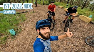
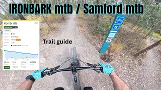
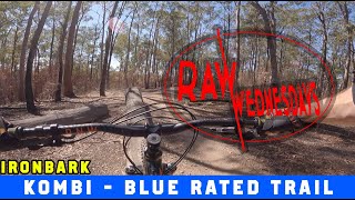
The first half is fun and flowy with some nice jumps and berms while the second half requires a fair bit of pedaling to maintain a decent speed.

Adaptive Bike Info
aMTB Black Rating: Advanced obstacles exist, some trail obstructions.

Narrow between the grass at the top but opens up wider after that. A decent off camber part just after passing the Kombi on the lower side. The last corner is too tight to get around but is the only "major obstacle" and worth the effort

Local Trail Association
Traditionally Indigenous Territory

Recent Activity on Trail

Past Week
  • 16 rides
  • 12 miles average
6 Months
  • 385 rides
  • 11 miles avg distance
All
  • 3,767 rides
  • Last: Jun 21, 2026
c1c2c3c4
January
February
March
April
May
June
July
August
September
October
November
December
update trails status or condition

Kombi (8) Trail Reports

statusdatedescription
May 31, 2026 @ 12:12pm (Australia/Brisbane)
May 30, 2026
Dry with some puddles bit of water in the creek
May 2, 2026 @ 8:29am (Australia/Brisbane)
May 1, 2026
Jan 28, 2026 @ 1:37pm (Australia/Brisbane)
Jan 27, 2026
Very nice trail.. recommended
Nov 25, 2025 @ 12:08pm (Australia/Brisbane)
Nov 24, 2025
Tree down across the trail, roughly half way down. Advise lowering speed, as you’ll very likely need to stop and carry your bike over...
Sep 27, 2025 @ 6:32am (Australia/Brisbane)
Sep 26, 2025
more »
Status:
on May 31, 2026
Variable
Avg: 4.54 (40 votes)
Your vote: 0

view (40,718)
close
3D
Trail Conditions
  • Unknown
  • Snow Groomed
  • Snow Packed
  • Snow Covered
  • Snow Cover Partial
  • Freeze/thaw Cycle
  • Icy
  • Prevalent Mud
  • Wet
  • Variable
  • Ideal
  • Dry
  • Very Dry
Trail Flow (Ridden Direction)
Trailforks scans users ridelogs to determine the most popular direction each trail is ridden. A good flowing trail network will have most trails flowing in a single direction according to their intension.
The colour categories are based on what percentage of riders are riding a trail in its intended direction.
  • > 96%
  • > 90%
  • > 80%
  • > 70%
  • > 50%
  • < 50%
  • bi-directional trail
  • no data
Trail Last Ridden
Trailforks scans ridelogs to determine the last time a trail was ridden.
  • < 2 days
  • < 1 week
  • < 2 weeks
  • < 1 month
  • < 6 months
  • > 6 months
Trail Ridden Direction
The intended direction a trail should be ridden.
  • Downhill Only
  • Downhill Primary
  • Both Directions
  • Uphill Primary
  • Uphill Only
  • One Direction
Contribute Details
Colors indicate trail is missing specified detail.
  • Description
  • Photos
  • Description & Photos
  • Videos
Trail Popularity ?
Trailforks scans ridelogs to determine which trails are ridden the most in the last 9 months. Trails are compared with nearby trails in the same city region with a possible 25 colour shades. Think of this as a heatmap, more rides = more kinetic energy = warmer colors.
  • most popular
  • popular
  • less popular
  • not popular
ATV/ORV/OHV Filter
Max Vehicle Width
inches
US Cell Coverage
Legend
cell carrier legend

Radar Time
Activity Recordings
Trailforks uses anonymized public activity data. ?
Activity Recordings
Trailforks uses anonymized public activity data. ?
Personal Heatmap
Activity Types
all / none
Options
2
Date range month
Winter Trails
Warning A routing network for winter maps does not exist. Selecting trails using the winter trails layer has been disabled.
Missing Trails
Most Popular
Least Popular
Trails are colored based on popularity. The more popular a trail is, the more red. Less popular trails trend towards green.
Jump Magnitude Heatmap
Heatmap of where riders jump on trails. Zoom in to see individual jumps, click circles to view jump details.
BC Backroad Status

Service Road Atlas is a free to use, community-driven service for viewing and creating reports on the numerous back-country service roads around B.C. and Alberta.

map legend
Slope Aspect
Direction the slope faces
Flat N NE E SE S SW W NW
Trails Deemphasized
Trails are shown in grey.
disable
Only show trails with no bike usage.
Enable
Suggested Layers
Based on selected activity type

    Save the current map location and zoom level as your default home location whenever this page is loaded.

    Save
        Directions to kombi-8 trailhead (-27.381060, 152.910480)

        Photos

        13 more »
        97 |
        May 19, 2024 @ 7:25pm
        May 19, 2024
        108 |
        May 19, 2024 @ 7:24pm
        May 19, 2024
        232 |
        Apr 1, 2022 @ 5:10pm
        Apr 1, 2022
        412 |
        May 26, 2020 @ 7:23am
        May 26, 2020

        Videos

        12 more »
        youtuber New Year, New Bikes - Samford
        15:11 | 812 | Jan 15, 2022 , Brisbane
        Ironbark MTB / Samford MTB | Trail guide,...
        6:20 | 174 | Oct 19, 2025 , Brisbane
        youtuber This place is better then I remember!
        10:27 | 293 | Mar 27, 2023 , Brisbane
        youtuber Kombi | Ironbark/Samford | RAW WEDNESDAYS
        6:23 | 743 | Nov 10, 2021 , Brisbane

        Trail Events

        21 Reviews & Comments


        We hope you've been enjoying Trailforks!

        Create a FREE account to view trail comments and much more.

        • By Rodhickey & contributors
        • #54601 - 20,711 views

        Frequently Asked Questions About Kombi (8)

        Where is Kombi (8) located?
        Kombi (8) is located in Samford Conservation Park, Brisbane, Australia. It is part of the Samford Conservation Park trail network. The trailhead is located at coordinates -27.38106, 152.91048.
        How hard is Kombi (8)?
        Kombi (8) is rated as Blue difficulty. The physical rating is Moderate. The average grade is 4.1%.
        What is the elevation gain for Kombi (8)?
        Kombi (8) has 31 ft of elevation gain. The trail has 369 ft of elevation descent. The elevation ranges from 326 ft to 666 ft.
        Is Kombi (8) a point to point trail?
        Yes, Kombi (8) is a point to point trail. The direction is Downhill Only. The trail type is machine groomed.

        Hit the Trail

        Open in App

        Get this trail on your phone instantly.
        open trail in app

        Download Trail

        Save to wishlist, Garmin & download.
        save the trail

        Find Related Routes

        Find routes and users activities that include this trail.
        find routes for this trail

        You must enter a description before submitting.