
Open in App
Get this trail on your phone instantly.

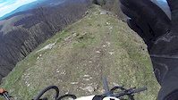
Turistický chodník z vrcholu Kozieho chrbta (1330 m.n.m.). Vrchná pasáž je celkom kamenistá a technická, ale zvyšok vám umožní ísť rýchlejšie a užiť si hlinu pod vašimi kolesami. Úchvatné scenérie sú tiež niečím, čo nenájdete hocikde.
Hiking trail from the summit of Kozí chrbát (1330 m). The top section is quite rocky and technical, but the rest will allow you to go faster and enjoy the dirt beneath your wheels. The stunning sceneries are also something that cannot be found anywhere.
This trail is unsanctioned.
| c1 | c2 | c3 | c4 |
|---|---|---|---|
January | February | March | April |
May | June | July | August |
September | October | November | December |

Service Road Atlas is a free to use, community-driven service for viewing and creating reports on the numerous back-country service roads around B.C. and Alberta.
Save the current map location and zoom level as your default home location whenever this page is loaded.
Save
No reviews yet, be the first to write a review or ask a question.
Use trail reports to comment on trail conditions.
We hope you've been enjoying Trailforks!
Create a FREE account to view trail comments and much more.
You must enter a description before submitting.

