

Open in App
Get this trail on your phone instantly.

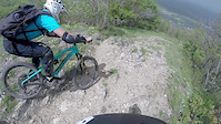
The upper part of the trail starts with rocky sections and steep switchbacks with loose rocks. In the middle, the switchbacks become easier and with less rocks. In the end, you can either cut the switchbacks with the many possible lines, or just continue practicing them. The last part of the route is the returning back to Boyana district. The trail is used by hikers, so be careful
| c1 | c2 | c3 | c4 |
|---|---|---|---|
January | February | March | April |
May | June | July | August |
September | October | November | December |

Service Road Atlas is a free to use, community-driven service for viewing and creating reports on the numerous back-country service roads around B.C. and Alberta.
Save the current map location and zoom level as your default home location whenever this page is loaded.
SaveWe hope you've been enjoying Trailforks!
Create a FREE account to view trail comments and much more.
You must enter a description before submitting.

