more stats
3,140 ft
Distance
-427 ft
Descent
00:04:56
Avg time
-434 ft
Altitude change
1,912 ft
Altitude min
2,346 ft
Altitude max
2,346 ft
Altitude start
1,913 ft
Altitude end
-13.8%
Grade
-44.1%
Grade max
-0.7%
Grade min
3,127 ft
Distance down
13 ft
Distance flat
00:04:56
Avg time

Kudłata Details

  • Activities
    • Mountain Bike
    • E-Bike
    • Hike
    • Trail Running
  • Riding Area
  • Difficulty Rating
  • Local Popularity
    35 in Mountain Biking [+]
    • 40 in E-Biking
    • 5 in Trail Running
    • 5 in Hiking
  • Global Ranking
    #106786 in Mountain Biking [+]
    • #90118 in E-Biking
    • #133663 in Trail Running
    • #127068 in Hiking
  • Trail Type
    Singletrack
  • Bike Type
    DH, AM
  • Direction
    Downhill Primary
    Popular Direction Shown
  • Dogs Allowed
    Yes
  • eBike Allowed
    Yes up to Class 1

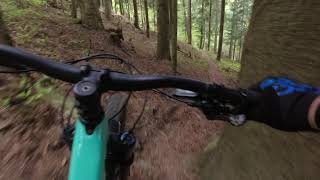
Świetny naturalny singiel, wychodzona przez ludzi lekko opadająca, ściółkowa ścieżka bez żadnych trudności technicznych. Po zjeździe warto wstąpić na lody do cukierni w budynku Supermarketu Lewiatana. Razz

Nice, flowy natural singletrack. Highly recommended ice creams by the Leviatan Supermarket in the Center of Zawoja.

This trail is unsanctioned.

Recent Activity on Trail

Past Week
  • 0 rides
  •  
6 Months
  • 0 rides
  •  
All
  • 10 rides
  • Last: May 2, 2026
c1c2c3c4
January
February
March
April
May
June
July
August
September
October
November
December
update trails status or condition

Kudłata Trail Reports

statusdatedescription
Jul 7, 2024 @ 7:04am
Jul 7, 2024
Sama przyjemność
May 22, 2022 @ 6:22am
May 22, 2022
May 21, 2021 @ 9:19am
May 21, 2021
Jul 24, 2020 @ 8:15am
Jul 24, 2020
W górnej części na początku tak jakby kamienie z góry się obsypały z góry na ścieżkę, poza tym dalej miód
Apr 22, 2020 @ 7:15am
Apr 22, 2020
Super ścieżka szkoda że taka krótka, chciałoby się więcej !
more »
Status:
on Jul 7, 2024
Ideal
Avg: 4.21 (3 votes)
Your vote: 0

view (61)
close
3D
Trail Conditions
  • Unknown
  • Snow Groomed
  • Snow Packed
  • Snow Covered
  • Snow Cover Partial
  • Freeze/thaw Cycle
  • Icy
  • Prevalent Mud
  • Wet
  • Variable
  • Ideal
  • Dry
  • Very Dry
Trail Flow (Ridden Direction)
Trailforks scans users ridelogs to determine the most popular direction each trail is ridden. A good flowing trail network will have most trails flowing in a single direction according to their intension.
The colour categories are based on what percentage of riders are riding a trail in its intended direction.
  • > 96%
  • > 90%
  • > 80%
  • > 70%
  • > 50%
  • < 50%
  • bi-directional trail
  • no data
Trail Last Ridden
Trailforks scans ridelogs to determine the last time a trail was ridden.
  • < 2 days
  • < 1 week
  • < 2 weeks
  • < 1 month
  • < 6 months
  • > 6 months
Trail Ridden Direction
The intended direction a trail should be ridden.
  • Downhill Only
  • Downhill Primary
  • Both Directions
  • Uphill Primary
  • Uphill Only
  • One Direction
Contribute Details
Colors indicate trail is missing specified detail.
  • Description
  • Photos
  • Description & Photos
  • Videos
Trail Popularity ?
Trailforks scans ridelogs to determine which trails are ridden the most in the last 9 months. Trails are compared with nearby trails in the same city region with a possible 25 colour shades. Think of this as a heatmap, more rides = more kinetic energy = warmer colors.
  • most popular
  • popular
  • less popular
  • not popular
ATV/ORV/OHV Filter
Max Vehicle Width
inches
US Cell Coverage
Legend
cell carrier legend

Radar Time
Activity Recordings
Trailforks uses anonymized public activity data. ?
Activity Recordings
Trailforks uses anonymized public activity data. ?
Personal Heatmap
Activity Types
all / none
Options
2
Date range month
Winter Trails
Warning A routing network for winter maps does not exist. Selecting trails using the winter trails layer has been disabled.
Missing Trails
Most Popular
Least Popular
Trails are colored based on popularity. The more popular a trail is, the more red. Less popular trails trend towards green.
Jump Magnitude Heatmap
Heatmap of where riders jump on trails. Zoom in to see individual jumps, click circles to view jump details.
BC Backroad Status

Service Road Atlas is a free to use, community-driven service for viewing and creating reports on the numerous back-country service roads around B.C. and Alberta.

map legend
Slope Aspect
Direction the slope faces
Flat N NE E SE S SW W NW
Trails Deemphasized
Trails are shown in grey.
disable
Only show trails with no bike usage.
Enable
Suggested Layers
Based on selected activity type

    Save the current map location and zoom level as your default home location whenever this page is loaded.

    Save
        Directions to kud-ata trailhead (49.647270, 19.565510)

        Photos

        No photos have been added for Kudłata yet, add a photo.

        Videos

        1 more »
        Kudłata
        2:13 | 236 | May 21, 2021 , Zawoja

        1 Review & Comments


        We hope you've been enjoying Trailforks!

        Create a FREE account to view trail comments and much more.

        • #130537 - 827 views

        Frequently Asked Questions About Kudłata

        Where is Kudłata located?
        Kudłata is located in Zawoja, Poland. It is part of the Zawoja trail network. The trailhead is located at coordinates 49.64727, 19.56551.
        How hard is Kudłata?
        Kudłata is rated as Blue difficulty. The average grade is 13.8%.
        What is the elevation gain for Kudłata?
        The trail has 130 m of elevation descent. The elevation ranges from 583 m to 715 m.
        Is Kudłata a point to point trail?
        Kudłata is not a point to point trail. The direction is Downhill Primary. The trail type is singletrack.

        Hit the Trail

        Open in App

        Get this trail on your phone instantly.
        open trail in app

        Download Trail

        Save to wishlist, Garmin & download.
        save the trail

        Find Related Routes

        Find routes and users activities that include this trail.
        find routes for this trail

        You must enter a description before submitting.