more stats
328 ft
Distance
-8 ft
Descent
00:00:12
Avg time
-8 ft
Altitude change
464 ft
Altitude min
472 ft
Altitude max
472 ft
Altitude start
466 ft
Altitude end
-2.5%
Grade
-4.5%
Grade max
194 ft
Distance down
135 ft
Distance flat
00:00:12
Avg time

Kunstgrasutsikten Details

  • Activities
    • Mountain Bike
    • E-Bike
    • Winter Fat Bike
    • Hike
    • Trail Running
  • Riding Area
  • Difficulty Rating
  • Local Popularity
    90 in Mountain Biking [+]
    • 5 in E-Biking
    • 5 in Trail Running
    • 5 in Hiking
  • Global Ranking
    #56954 in Mountain Biking [+]
    • #109399 in E-Biking
    • #147943 in Trail Running
    • #143950 in Hiking
  • Hiking SAC Scale
    T1 Hiking
  • Trail Type
    Singletrack
  • Bike Type
    AM, XC, Fat
  • Direction
    Both Directions
  • Climb Difficulty
    Black Diamond
  • Physical Rating
    Hard
  • Trail Visibility
    Always easy to follow
  • Dogs Allowed
    Yes
  • eBike Allowed
    Yes up to Class 1
  • TTFs on Trail
    Drop, Rock Face, Skinny

Norsk
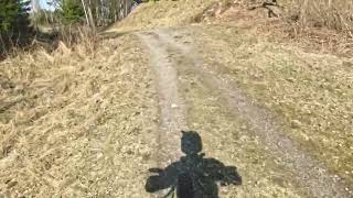
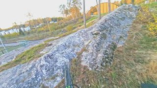
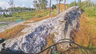
Stien er lettes nedover, men kan tas begge retninger. Fra toppen starter stien med en hump med røtter opp berget, litt opp og ned på røtter og berg, til man kommer oppå toppen av jevnt fjellet, der er det smalt og ca 1 m høyt stup, og skrått fjell på høyre side, så har man valg mellom to utganger mellom stein. Så her må man velge riktig linje for å komme seg ut, eventuelt løfte bakhjulet hvis du er for sen.

English
The trail is easy going down, but can be taken in both directions. From the top, the path starts with a hump with roots up the rock, a little up and down on roots and rock, until you reach the top of the smooth mountain, there is a narrow and approx. 1 m high drop, and sloping mountain on the right side, then you have choice between two exits between rocks. So here you have to choose the right line to get out, possibly lift the rear wheel if you are too late.

Local Trail Association

Recent Activity on Trail

Past Week
  • 0 rides
  •  
6 Months
  • 0 rides
  •  
All
  • 23 rides
  • Last: Jun 22, 2025
c1c2c3c4
January
February
March
April
May
June
July
August
September
October
November
December
update trails status or condition

Kunstgrasutsikten Trail Reports

statusdatedescription
Oct 2, 2023 @ 9:48am
Oct 2, 2023
Ideal
Nov 7, 2020 @ 1:37am
Nov 7, 2020
reporter
Jan 11, 2019 @ 7:45am
Jan 11, 2019
reporter unstable loose snow cover on the whole trail, easy to spin and lose control, a lot harder to ride, as the snow has not been packed down. it will...
Nov 23, 2018 @ 11:54am
Nov 23, 2018
reporter
Jun 15, 2018 @ 3:04pm
Jun 15, 2018
reporter
more »
Status:
on Oct 2, 2023
Ideal
Avg: 4.13 (1 votes)
Your vote: 0

view (39)
close
3D
Trail Conditions
  • Unknown
  • Snow Groomed
  • Snow Packed
  • Snow Covered
  • Snow Cover Partial
  • Freeze/thaw Cycle
  • Icy
  • Prevalent Mud
  • Wet
  • Variable
  • Ideal
  • Dry
  • Very Dry
Trail Flow (Ridden Direction)
Trailforks scans users ridelogs to determine the most popular direction each trail is ridden. A good flowing trail network will have most trails flowing in a single direction according to their intension.
The colour categories are based on what percentage of riders are riding a trail in its intended direction.
  • > 96%
  • > 90%
  • > 80%
  • > 70%
  • > 50%
  • < 50%
  • bi-directional trail
  • no data
Trail Last Ridden
Trailforks scans ridelogs to determine the last time a trail was ridden.
  • < 2 days
  • < 1 week
  • < 2 weeks
  • < 1 month
  • < 6 months
  • > 6 months
Trail Ridden Direction
The intended direction a trail should be ridden.
  • Downhill Only
  • Downhill Primary
  • Both Directions
  • Uphill Primary
  • Uphill Only
  • One Direction
Contribute Details
Colors indicate trail is missing specified detail.
  • Description
  • Photos
  • Description & Photos
  • Videos
Trail Popularity ?
Trailforks scans ridelogs to determine which trails are ridden the most in the last 9 months. Trails are compared with nearby trails in the same city region with a possible 25 colour shades. Think of this as a heatmap, more rides = more kinetic energy = warmer colors.
  • most popular
  • popular
  • less popular
  • not popular
ATV/ORV/OHV Filter
Max Vehicle Width
inches
US Cell Coverage
Legend
cell carrier legend

Radar Time
Activity Recordings
Trailforks uses anonymized public activity data. ?
Activity Recordings
Trailforks uses anonymized public activity data. ?
Personal Heatmap
Activity Types
all / none
Options
2
Date range month
Winter Trails
Warning A routing network for winter maps does not exist. Selecting trails using the winter trails layer has been disabled.
Missing Trails
Most Popular
Least Popular
Trails are colored based on popularity. The more popular a trail is, the more red. Less popular trails trend towards green.
Jump Magnitude Heatmap
Heatmap of where riders jump on trails. Zoom in to see individual jumps, click circles to view jump details.
BC Backroad Status

Service Road Atlas is a free to use, community-driven service for viewing and creating reports on the numerous back-country service roads around B.C. and Alberta.

map legend
Slope Aspect
Direction the slope faces
Flat N NE E SE S SW W NW
Trails Deemphasized
Trails are shown in grey.
disable
Only show trails with no bike usage.
Enable
Suggested Layers
Based on selected activity type

    Save the current map location and zoom level as your default home location whenever this page is loaded.

    Save
        Directions to kunstgrasutsikten trailhead (59.586480, 11.155270)

        Photos

        11 more »
        19 |
        Sep 10, 2024 @ 5:58am
        Sep 10, 2024
        20 |
        Sep 10, 2024 @ 5:58am
        Sep 10, 2024
        23 |
        Sep 10, 2024 @ 5:57am
        Sep 10, 2024
        19 |
        Sep 10, 2024 @ 5:57am
        Sep 10, 2024

        Videos

        7 more »
        youtuber 20 April 2023 Prestegårdsskogen
        6:02 | 108 | Dec 9, 2023 , Askim
        youtuber 14.11.2020 A stick broke the derailleur hanger
        5:03 | 186 | Nov 7, 2020 , Askim
        youtuber 02 Feb gnarly in the dark
        3:09 | 164 | Feb 27, 2020 , Askim
        youtuber 7 august 2019 the bare rock next to Askim...
        0:35 | 196 | Feb 8, 2020 , Askim

        Reviews / Comments

        No reviews yet, be the first to write a review or ask a question.
        Use trail reports to comment on trail conditions.


        We hope you've been enjoying Trailforks!

        Create a FREE account to view trail comments and much more.

        Frequently Asked Questions About Kunstgrasutsikten

        Where is Kunstgrasutsikten located?
        Kunstgrasutsikten is located in Prestegårdsskogen, Askim, Norway. It is part of the Prestegårdsskogen trail network. The trailhead is located at coordinates 59.58648, 11.15527.
        How hard is Kunstgrasutsikten?
        Kunstgrasutsikten is rated as Red difficulty. The physical rating is Hard. The average grade is 2.5%. The climb difficulty is rated Black Diamond.
        What is the elevation gain for Kunstgrasutsikten?
        The trail has 8 ft of elevation descent. The elevation ranges from 464 ft to 472 ft.
        Is Kunstgrasutsikten a point to point trail?
        Kunstgrasutsikten is not a point to point trail. The direction is Both Directions. The trail type is singletrack.

        Hit the Trail

        Open in App

        Get this trail on your phone instantly.
        open trail in app

        Download Trail

        Save to wishlist, Garmin & download.
        save the trail

        Find Related Routes

        Find routes and users activities that include this trail.
        find routes for this trail

        You must enter a description before submitting.