more stats
2.6 miles
Distance
486 ft
Climb
-63 ft
Descent
00:37:38
Avg time
426 ft
Altitude change
6,402 ft
Altitude min
6,827 ft
Altitude max
6,402 ft
Altitude start
6,827 ft
Altitude end
3.1%
Grade
-21%
Grade max
25.6%
Grade min
2 miles
Distance climb
1,220 ft
Distance down
1,191 ft
Distance flat
00:37:38
Avg time

La Mosca Details

  • Activities
    • Mountain Bike
    • E-Bike
    • Hike
    • Trail Running
  • Riding Area
  • Difficulty Rating
  • Local Popularity
    85 in Mountain Biking [+]
    • 75 in E-Biking
    • 75 in Trail Running
    • 5 in Hiking
  • Global Ranking
    #49141 in Mountain Biking [+]
    • #47806 in E-Biking
    • #71982 in Trail Running
    • #125126 in Hiking
  • Trail Type
    Singletrack
  • Bike Type
    AM, XC
  • Climb Difficulty
    Green
  • Physical Rating
    Moderate
  • Season
    Noviembre-julio
  • eBike Allowed
    Yes up to Class 1
  • Land Owner
    Bosque la Primavera

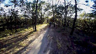
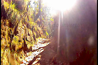
Una de las primeras y mas famosas veredas del Bosque la Primavera. La Mosca fue nombra así gracias a que el Dr. Oskar A.K.A La Mosca se atrevió a descubrir la vereda en los inicios del ciclismo de montaña, hace mas de 30 años.

Vereda con una subidas y bajadas con habilidad intermedia, en su mayoría es un single tracks en un solo sentido, esta vereda conecta con el descenso Toboganes y la vereda Glorieta.

Trail Supporters
Local Trail Association
Traditionally Indigenous Territory

Recent Activity on Trail

Past Week
  • 3 rides
  • 21 miles average
6 Months
  • 38 rides
  • 16 miles avg distance
All
  • 124 rides
  • Last: Jun 28, 2026
c1c2c3c4
January
February
March
April
May
June
July
August
September
October
November
December
Status:
on May 16, 2026
Dry
Avg: 4.1 (4 votes)
Your vote: 0

view (1,137)
close
3D
Trail Conditions
  • Unknown
  • Snow Groomed
  • Snow Packed
  • Snow Covered
  • Snow Cover Partial
  • Freeze/thaw Cycle
  • Icy
  • Prevalent Mud
  • Wet
  • Variable
  • Ideal
  • Dry
  • Very Dry
Trail Flow (Ridden Direction)
Trailforks scans users ridelogs to determine the most popular direction each trail is ridden. A good flowing trail network will have most trails flowing in a single direction according to their intension.
The colour categories are based on what percentage of riders are riding a trail in its intended direction.
  • > 96%
  • > 90%
  • > 80%
  • > 70%
  • > 50%
  • < 50%
  • bi-directional trail
  • no data
Trail Last Ridden
Trailforks scans ridelogs to determine the last time a trail was ridden.
  • < 2 days
  • < 1 week
  • < 2 weeks
  • < 1 month
  • < 6 months
  • > 6 months
Trail Ridden Direction
The intended direction a trail should be ridden.
  • Downhill Only
  • Downhill Primary
  • Both Directions
  • Uphill Primary
  • Uphill Only
  • One Direction
Contribute Details
Colors indicate trail is missing specified detail.
  • Description
  • Photos
  • Description & Photos
  • Videos
Trail Popularity ?
Trailforks scans ridelogs to determine which trails are ridden the most in the last 9 months. Trails are compared with nearby trails in the same city region with a possible 25 colour shades. Think of this as a heatmap, more rides = more kinetic energy = warmer colors.
  • most popular
  • popular
  • less popular
  • not popular
ATV/ORV/OHV Filter
Max Vehicle Width
inches
US Cell Coverage
Legend
cell carrier legend

Radar Time
Activity Recordings
Trailforks uses anonymized public activity data. ?
Activity Recordings
Trailforks uses anonymized public activity data. ?
Personal Heatmap
Activity Types
all / none
Options
2
Date range month
Winter Trails
Warning A routing network for winter maps does not exist. Selecting trails using the winter trails layer has been disabled.
Missing Trails
Most Popular
Least Popular
Trails are colored based on popularity. The more popular a trail is, the more red. Less popular trails trend towards green.
Jump Magnitude Heatmap
Heatmap of where riders jump on trails. Zoom in to see individual jumps, click circles to view jump details.
BC Backroad Status

Service Road Atlas is a free to use, community-driven service for viewing and creating reports on the numerous back-country service roads around B.C. and Alberta.

map legend
Slope Aspect
Direction the slope faces
Flat N NE E SE S SW W NW
Trails Deemphasized
Trails are shown in grey.
disable
Only show trails with no bike usage.
Enable
Suggested Layers
Based on selected activity type

    Save the current map location and zoom level as your default home location whenever this page is loaded.

    Save
        Directions to la-mosca trailhead (20.616530, -103.515800)

        Photos

        22 more »
        49 |
        Mar 9, 2025 @ 11:11pm
        Mar 9, 2025
        46 |
        Mar 9, 2025 @ 11:11pm
        Mar 9, 2025
        45 |
        Mar 9, 2025 @ 11:10pm
        Mar 9, 2025
        52 |
        Jan 10, 2025 @ 1:30pm
        Jan 10, 2025

        Videos

        5 more »
        Caida del gato
        0:30 | 303 | Apr 6, 2016 , Zapopan
        ONE PROJECT
        2:12 | 133 | May 15, 2016 , Zapopan
        La Mosca Sessions
        2:32 | 293 | Jun 16, 2012 , Zapopan
        Vereda 'La Mosca'
        5:32 | 380 | Oct 25, 2014 , Zapopan

        Routes with this trail

        16 miles 1,950 ft 6 Loop
        Loop clasico en los trails mas populares de la primavera jalisco, existen formas de hacerlo mas corto o...
        8 miles 836 ft 6 Loop
        Loop clasico simplificado
        26 miles 2,656 ft 3
        Ruta difícil de postes a

        Reviews / Comments

        No reviews yet, be the first to write a review or ask a question.
        Use trail reports to comment on trail conditions.


        We hope you've been enjoying Trailforks!

        Create a FREE account to view trail comments and much more.

        • By primaveramtb & contributors
        • #31289 - 4,135 views

        Frequently Asked Questions About La Mosca

        Where is La Mosca located?
        La Mosca is located in Bosque La Primavera Trail Network, Zapopan, México. It is part of the Bosque La Primavera Trail Network trail network. The trailhead is located at coordinates 20.61653, -103.5158.
        How hard is La Mosca?
        La Mosca is rated as Blue difficulty. The physical rating is Moderate. The average grade is 3.1%. The climb difficulty is rated Green.
        What is the elevation gain for La Mosca?
        La Mosca has 486 ft of elevation gain. The trail has 63 ft of elevation descent. The elevation ranges from 6,402 ft to 6,827 ft.
        How long is La Mosca?
        La Mosca is 2.6 miles long. The trail type is singletrack.

        Hit the Trail

        Open in App

        Get this trail on your phone instantly.
        open trail in app

        Download Trail

        Save to wishlist, Garmin & download.
        save the trail

        Find Related Routes

        Find routes and users activities that include this trail.
        find routes for this trail

        You must enter a description before submitting.