more stats
4.0 miles
Distance
340 ft
Climb
-1,060 ft
Descent
00:45:04
Avg time
-720 ft
Altitude change
2,702 ft
Altitude min
3,450 ft
Altitude max
3,422 ft
Altitude start
2,703 ft
Altitude end
-3.4%
Grade
-37.3%
Grade max
33.7%
Grade min
1 mile
Distance climb
3 miles
Distance down
1,266 ft
Distance flat
00:45:04
Avg time

La Paco Details

  • Activities
    • Mountain Bike
  • Riding Area
    Cerro Catedral
    San Carlos de Bariloche
  • Difficulty Rating
  • Voted Difficulty
    Black Diamond (3 votes)
  • Local Popularity
    100 in Mountain Biking
  • Global Ranking
    #33905 in Mountain Biking
  • Trail Type
    Singletrack
  • Bike Type
    AM, XC
  • Direction
    Downhill Primary
    Popular Direction Shown
  • Climb Difficulty
    Green
  • Physical Rating
    Easy
  • Dogs Allowed
    Yes
  • TTFs on Trail
    Bridge, Jump, Rock Face, Rock Garden

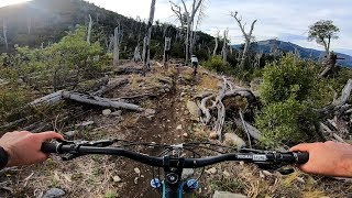
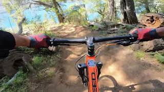
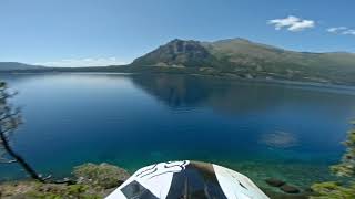
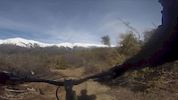
La paco es uno de los recorridos más transitados por los ciclistas tanto locales como los que visitan Bariloche. Es uno recorrido exclusivo para bicis dentro del parque nacional y conecta el cerro catedral con el Lago Gutierrez con la posibilidad de aprovechar para combinar bici y lago.
Su recorrido es bastante flow y alterna lugares más planos con algunas partes más tecnicas en el sector inferior que pueden ser dificiles cuando esta muy seco el terreno.
Sin duda es una de las que si o si tenes que hacer en Bariloche

Traditionally Indigenous Territory

Recent Activity on Trail

Past Week
  • 1 rides
  • 17 miles average
6 Months
  • 34 rides
  • 15 miles avg distance
All
  • 125 rides
  • Last: Jun 17, 2026
c1c2c3c4
January
February
March
April
May
June
July
August
September
October
November
December
update trails status or condition

La Paco Trail Reports

statusdatedescription
May 20, 2026 @ 12:49pm (America/Coyhaique)
May 20, 2026
Sep 25, 2025 @ 12:05pm (America/Coyhaique)
Sep 25, 2025
Same as aug 18
Aug 18, 2025 @ 1:12pm
Aug 18, 2025
Mucho barro hasta el cartel! Despues linda la bajada
Jan 23, 2025 @ 2:45pm
Jan 23, 2025
Minor erosion (trail braiding, small ruts developing, brake bumps)
Jan 6, 2025 @ 8:18am
Jan 6, 2025
more »
Status:
on May 20, 2026
Variable
Avg: 4.26 (12 votes)
Your vote: 0

view (734)
close
3D
Trail Conditions
  • Unknown
  • Snow Groomed
  • Snow Packed
  • Snow Covered
  • Snow Cover Partial
  • Freeze/thaw Cycle
  • Icy
  • Prevalent Mud
  • Wet
  • Variable
  • Ideal
  • Dry
  • Very Dry
Trail Flow (Ridden Direction)
Trailforks scans users ridelogs to determine the most popular direction each trail is ridden. A good flowing trail network will have most trails flowing in a single direction according to their intension.
The colour categories are based on what percentage of riders are riding a trail in its intended direction.
  • > 96%
  • > 90%
  • > 80%
  • > 70%
  • > 50%
  • < 50%
  • bi-directional trail
  • no data
Trail Last Ridden
Trailforks scans ridelogs to determine the last time a trail was ridden.
  • < 2 days
  • < 1 week
  • < 2 weeks
  • < 1 month
  • < 6 months
  • > 6 months
Trail Ridden Direction
The intended direction a trail should be ridden.
  • Downhill Only
  • Downhill Primary
  • Both Directions
  • Uphill Primary
  • Uphill Only
  • One Direction
Contribute Details
Colors indicate trail is missing specified detail.
  • Description
  • Photos
  • Description & Photos
  • Videos
Trail Popularity ?
Trailforks scans ridelogs to determine which trails are ridden the most in the last 9 months. Trails are compared with nearby trails in the same city region with a possible 25 colour shades. Think of this as a heatmap, more rides = more kinetic energy = warmer colors.
  • most popular
  • popular
  • less popular
  • not popular
ATV/ORV/OHV Filter
Max Vehicle Width
inches
US Cell Coverage
Legend
cell carrier legend

Radar Time
Activity Recordings
Trailforks uses anonymized public activity data. ?
Activity Recordings
Trailforks uses anonymized public activity data. ?
Personal Heatmap
Activity Types
all / none
Options
2
Date range month
Winter Trails
Warning A routing network for winter maps does not exist. Selecting trails using the winter trails layer has been disabled.
Missing Trails
Most Popular
Least Popular
Trails are colored based on popularity. The more popular a trail is, the more red. Less popular trails trend towards green.
Jump Magnitude Heatmap
Heatmap of where riders jump on trails. Zoom in to see individual jumps, click circles to view jump details.
BC Backroad Status

Service Road Atlas is a free to use, community-driven service for viewing and creating reports on the numerous back-country service roads around B.C. and Alberta.

map legend
Slope Aspect
Direction the slope faces
Flat N NE E SE S SW W NW
Trails Deemphasized
Trails are shown in grey.
disable
Only show trails with no bike usage.
Enable
Suggested Layers
Based on selected activity type

    Save the current map location and zoom level as your default home location whenever this page is loaded.

    Save
        Directions to la-paco trailhead (-41.173177, -71.435043)

        Photos

        21 more »
        37 |
        Jun 3, 2026 @ 4:18am
        Jun 3, 2026
        53 |
        Jan 13, 2026 @ 5:11pm
        Jan 13, 2026
        32 |
        Jan 13, 2026 @ 5:11pm
        Jan 13, 2026
        19 |
        Jan 13, 2026 @ 5:11pm
        Jan 13, 2026

        Videos

        4 more »
        youtuber La Paco - Cerro Catedral
        6:19 | 1282 | May 8, 2019 , San Carlos de Bariloche
        Sendero Mountain Bike Paco Echegaray - Cerro...
        20:05 | 655 | Dec 25, 2022 , San Carlos de Bariloche
        Dani - Night Owl - Bariloche
        8:46 | 432 | Feb 16, 2020 , San Carlos de Bariloche
        15 de septiembre 2017
        4:23 | 213 | Sep 17, 2017 , San Carlos de Bariloche

        Routes with this trail

        5.0 18 miles 5,378 ft 1 Race

        6 Reviews & Comments


        We hope you've been enjoying Trailforks!

        Create a FREE account to view trail comments and much more.

        • By MTBarTF Pro & contributors
        • #29624 - 6,457 views

        Frequently Asked Questions About La Paco

        Where is La Paco located?
        La Paco is located in Cerro Catedral, San Carlos de Bariloche, Argentina. It is part of the Cerro Catedral trail network. The trailhead is located at coordinates -41.17318, -71.43504.
        How hard is La Paco?
        La Paco is rated as Blue difficulty. The physical rating is Easy. The average grade is 3.4%. The climb difficulty is rated Green.
        What is the elevation gain for La Paco?
        La Paco has 104 m of elevation gain. The trail has 323 m of elevation descent. The elevation ranges from 824 m to 1,052 m.
        Is La Paco a point to point trail?
        La Paco is not a point to point trail. The direction is Downhill Primary. The trail type is singletrack.

        Hit the Trail

        Open in App

        Get this trail on your phone instantly.
        open trail in app

        Download Trail

        Save to wishlist, Garmin & download.
        save the trail

        Find Related Routes

        Find routes and users activities that include this trail.
        find routes for this trail

        You must enter a description before submitting.