more stats
2.9 miles
Distance
-1,765 ft
Descent
00:16:08
Avg time
-1,765 ft
Altitude change
820 ft
Altitude min
2,585 ft
Altitude max
2,585 ft
Altitude start
820 ft
Altitude end
-11.6%
Grade
-40.5%
Grade max
-0.6%
Grade min
3 miles
Distance down
00:16:08
Avg time

La Vietnam Details

  • Activities
    • Mountain Bike
    • E-Bike
  • Riding Area
    Mont-Sainte-Anne DH Park
    Beaupré, Quebec
  • Ref Number
    I
  • Difficulty Rating
  • Voted Difficulty
    Blue (1 vote)
  • Local Popularity
    100 in Mountain Biking [+]
    • 100 in E-Biking
  • Global Ranking
    #5856 in Mountain Biking
  • Trail Type
    Singletrack
  • Bike Type
    DH
  • Direction
    Downhill Only
    Popular Direction Shown
  • Trail Visibility
    Always easy to follow
  • eBike Allowed
  • TTFs on Trail
    Berm, Bridge, Drop, Jump
  • Land Owner
    Sépaq (Société des établissements de plein air du Québec)

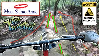
Fast Mix of flowy DH trail with old school straight wide DH trail with fast turns and berms ending with a rooty singletrack.

Un mix entre un sentier flowy nouveau genre et un sentier de type vieille école, avec ses lignes droites en ligne de pente entrecoupé de virages hyper rapides. Le sentier se finit par une section de singletrack racineux le long d'un ruisseau et de ponts de bois.

Access Info

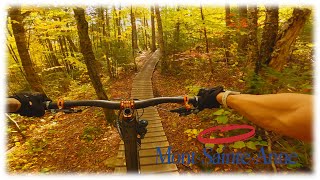
Top-to bottom from the gondola
De la gondole, du haut jusqu'en bas

Bike Park

Traditionally Indigenous Territory

Recent Activity on Trail

Past Week
  • 4 rides
  • 20 miles average
6 Months
  • 4 rides
  • 20 miles avg distance
All
  • 494 rides
  • Last: Jun 27, 2026
c1c2c3c4
January
February
March
April
May
June
July
August
September
October
November
December
update trails status or condition

La Vietnam Trail Reports

statusdatedescription
Dec 7, 2025 @ 3:31am (America/Toronto)
Dec 7, 2025
Fermé pour la saison, on se revoit en 2026! 🤠🤘 / Closed for the season, see you all in 2026! 🤠🤘
Oct 10, 2025 @ 11:17am (America/Moncton)
Oct 10, 2025
reporter
Jun 22, 2025 @ 1:02pm
Jun 22, 2025
Jan 13, 2025 @ 10:26am
Jan 13, 2025
reporter Fermée pour la saison / Closed for the season
Sep 27, 2024 @ 10:16am
Sep 27, 2024
more »
Status:
on Dec 7, 2025
Avg: 4.13 (31 votes)
Your vote: 0

view (4,125)
close
3D
Trail Conditions
  • Unknown
  • Snow Groomed
  • Snow Packed
  • Snow Covered
  • Snow Cover Partial
  • Freeze/thaw Cycle
  • Icy
  • Prevalent Mud
  • Wet
  • Variable
  • Ideal
  • Dry
  • Very Dry
Trail Flow (Ridden Direction)
Trailforks scans users ridelogs to determine the most popular direction each trail is ridden. A good flowing trail network will have most trails flowing in a single direction according to their intension.
The colour categories are based on what percentage of riders are riding a trail in its intended direction.
  • > 96%
  • > 90%
  • > 80%
  • > 70%
  • > 50%
  • < 50%
  • bi-directional trail
  • no data
Trail Last Ridden
Trailforks scans ridelogs to determine the last time a trail was ridden.
  • < 2 days
  • < 1 week
  • < 2 weeks
  • < 1 month
  • < 6 months
  • > 6 months
Trail Ridden Direction
The intended direction a trail should be ridden.
  • Downhill Only
  • Downhill Primary
  • Both Directions
  • Uphill Primary
  • Uphill Only
  • One Direction
Contribute Details
Colors indicate trail is missing specified detail.
  • Description
  • Photos
  • Description & Photos
  • Videos
Trail Popularity ?
Trailforks scans ridelogs to determine which trails are ridden the most in the last 9 months. Trails are compared with nearby trails in the same city region with a possible 25 colour shades. Think of this as a heatmap, more rides = more kinetic energy = warmer colors.
  • most popular
  • popular
  • less popular
  • not popular
ATV/ORV/OHV Filter
Max Vehicle Width
inches
US Cell Coverage
Legend
cell carrier legend

Radar Time
Activity Recordings
Trailforks uses anonymized public activity data. ?
Activity Recordings
Trailforks uses anonymized public activity data. ?
Personal Heatmap
Activity Types
all / none
Options
2
Date range month
Winter Trails
Warning A routing network for winter maps does not exist. Selecting trails using the winter trails layer has been disabled.
Missing Trails
Most Popular
Least Popular
Trails are colored based on popularity. The more popular a trail is, the more red. Less popular trails trend towards green.
Jump Magnitude Heatmap
Heatmap of where riders jump on trails. Zoom in to see individual jumps, click circles to view jump details.
BC Backroad Status

Service Road Atlas is a free to use, community-driven service for viewing and creating reports on the numerous back-country service roads around B.C. and Alberta.

map legend
Slope Aspect
Direction the slope faces
Flat N NE E SE S SW W NW
Trails Deemphasized
Trails are shown in grey.
disable
Only show trails with no bike usage.
Enable
Suggested Layers
Based on selected activity type

    Save the current map location and zoom level as your default home location whenever this page is loaded.

    Save
        Directions to la-vietnam trailhead (47.087360, -70.931730)

        Photos

        13 more »
        181 |
        Sep 1, 2021 @ 6:23pm
        Sep 1, 2021
        150 |
        Sep 1, 2021 @ 6:23pm
        Sep 1, 2021
        164 |
        Sep 1, 2021 @ 6:23pm
        Sep 1, 2021
        207 |
        Nov 24, 2018 @ 4:57pm
        Nov 24, 2018

        Videos

        20 more »
        youtuber MONT-SAINTE-ANNE 2020 - “La Tordue” - Dabs...
        20:06 | 784 | Sep 3, 2020 , Beaupré
        youtuber POV | ???????? La Vietnam - 'Improved' |...
        6:01 | 1457 | Aug 31, 2018 , Beaupré
        youtuber Forbidden Druid dans la Vietnam (review in...
        4:56 | 260 | Aug 14, 2023 , Beaupré
        youtuber All in à plus de 50km/h dans la Vietnam!
        6:57 | 469 | Mar 7, 2022 , Beaupré

        Trail Lists

        Routes with this trail

        6 miles 277 ft 4 Point to Point
        This is a very nice way to experience Mont-Sainte-Anne from the summit! Warm-up in before hitting the...
        4 miles 225 ft 6
        This is one of our favorite routes at Mont-Sainte-Anne and is featured in Freehub Magazine's Quebec City...
        1.0 25 miles 3,711 ft 85

        6 Reviews & Comments


        We hope you've been enjoying Trailforks!

        Create a FREE account to view trail comments and much more.

        Frequently Asked Questions About La Vietnam

        Where is La Vietnam located?
        La Vietnam is located in Mont-Sainte-Anne DH Park, Beaupré, Quebec, Canada. It is part of the Mont-Sainte-Anne DH Park trail network. The trailhead is located at coordinates 47.08736, -70.93173.
        How hard is La Vietnam?
        La Vietnam is rated as Black Diamond difficulty. The average grade is 11.6%.
        What is the elevation gain for La Vietnam?
        The trail has 1,765 ft of elevation descent. The elevation ranges from 820 ft to 2,585 ft.
        Is La Vietnam a point to point trail?
        Yes, La Vietnam is a point to point trail. The direction is Downhill Only. The trail type is singletrack.

        Hit the Trail

        Open in App

        Get this trail on your phone instantly.
        open trail in app

        Download Trail

        Save to wishlist, Garmin & download.
        save the trail

        Find Related Routes

        Find routes and users activities that include this trail.
        find routes for this trail

        You must enter a description before submitting.