more stats
1.2 miles
Distance
266 ft
Climb
-266 ft
Descent
00:11:47
Avg time
486 ft
Altitude min
531 ft
Altitude max
486 ft
Altitude start
486 ft
Altitude end
-43.6%
Grade max
42%
Grade min
1,808 ft
Distance climb
1,880 ft
Distance down
2,848 ft
Distance flat
00:11:47
Avg time

Lake Derby Details

  • Activities
    • Mountain Bike
    • E-Bike
    • Gravel Bike
    • Adaptive Bike
    • Winter Fat Bike
    • Hike
    • Trail Running
  • Riding Area
    Blue Derby
    Derby
  • Difficulty Rating
  • Voted Difficulty
    Green (1 vote)
  • Local Popularity
    70 in Mountain Biking [+]
    • 70 in E-Biking
    • 100 in Trail Running
    • 100 in Hiking
  • Global Ranking
    #38858 in Mountain Biking [+]
    • #47853 in E-Biking
    • #1321 in Trail Running
    • #2453 in Hiking
  • Trail Type
    Gravel Path
  • Bike Type
    AM, XC, Fat, Adaptive MTB, CX, Gravel
  • Climb Difficulty
    Green
  • Physical Rating
    Easy
  • Trail Visibility
    Always easy to follow
  • Dogs Allowed
    Yes
  • eBike Allowed
    Yes up to Class 1
  • Year Opened
    2018
  • Land Owner
    Dorset Council

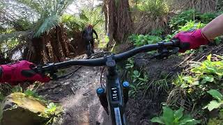
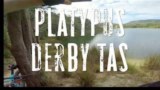
A family friendly trail that meanders and winds its way around the picturesque Lake Derby giving the rider plenty of opportunities to stop and take in the stunning surrounds. Multiple lookouts for platypus spotting or snapping photos and also a beautiful beach section is the ideal location for a swim and other water activities.

Trail Supporters
  • World Trail
    Builder
Local Trail Association
Traditionally Indigenous Territory

Recent Activity on Trail

Past Week
  • 0 rides
  •  
6 Months
  • 76 rides
  • 10 miles avg distance
All
  • 427 rides
  • Last: Jun 17, 2026
c1c2c3c4
January
February
March
April
May
June
July
August
September
October
November
December
update trails status or condition

Lake Derby Trail Reports

Status:
on Jan 1, 2026
Ideal
Avg: 3.94 (11 votes)
Your vote: 0

view (3,775)
close
3D
Trail Conditions
  • Unknown
  • Snow Groomed
  • Snow Packed
  • Snow Covered
  • Snow Cover Partial
  • Freeze/thaw Cycle
  • Icy
  • Prevalent Mud
  • Wet
  • Variable
  • Ideal
  • Dry
  • Very Dry
Trail Flow (Ridden Direction)
Trailforks scans users ridelogs to determine the most popular direction each trail is ridden. A good flowing trail network will have most trails flowing in a single direction according to their intension.
The colour categories are based on what percentage of riders are riding a trail in its intended direction.
  • > 96%
  • > 90%
  • > 80%
  • > 70%
  • > 50%
  • < 50%
  • bi-directional trail
  • no data
Trail Last Ridden
Trailforks scans ridelogs to determine the last time a trail was ridden.
  • < 2 days
  • < 1 week
  • < 2 weeks
  • < 1 month
  • < 6 months
  • > 6 months
Trail Ridden Direction
The intended direction a trail should be ridden.
  • Downhill Only
  • Downhill Primary
  • Both Directions
  • Uphill Primary
  • Uphill Only
  • One Direction
Contribute Details
Colors indicate trail is missing specified detail.
  • Description
  • Photos
  • Description & Photos
  • Videos
Trail Popularity ?
Trailforks scans ridelogs to determine which trails are ridden the most in the last 9 months. Trails are compared with nearby trails in the same city region with a possible 25 colour shades. Think of this as a heatmap, more rides = more kinetic energy = warmer colors.
  • most popular
  • popular
  • less popular
  • not popular
ATV/ORV/OHV Filter
Max Vehicle Width
inches
US Cell Coverage
Legend
cell carrier legend

Radar Time
Activity Recordings
Trailforks uses anonymized public activity data. ?
Activity Recordings
Trailforks uses anonymized public activity data. ?
Personal Heatmap
Activity Types
all / none
Options
2
Date range month
Winter Trails
Warning A routing network for winter maps does not exist. Selecting trails using the winter trails layer has been disabled.
Missing Trails
Most Popular
Least Popular
Trails are colored based on popularity. The more popular a trail is, the more red. Less popular trails trend towards green.
Jump Magnitude Heatmap
Heatmap of where riders jump on trails. Zoom in to see individual jumps, click circles to view jump details.
BC Backroad Status

Service Road Atlas is a free to use, community-driven service for viewing and creating reports on the numerous back-country service roads around B.C. and Alberta.

map legend
Slope Aspect
Direction the slope faces
Flat N NE E SE S SW W NW
Trails Deemphasized
Trails are shown in grey.
disable
Only show trails with no bike usage.
Enable
Suggested Layers
Based on selected activity type

    Save the current map location and zoom level as your default home location whenever this page is loaded.

    Save
        Directions to lake-derby trailhead (-41.145260, 147.802690)

        Photos

        4 more »
        61 |
        Apr 22, 2019 @ 6:03pm
        Apr 22, 2019
        146 |
        Apr 1, 2019 @ 12:39am
        Apr 1, 2019
        91 |
        Feb 29, 2020 @ 2:11pm
        Feb 29, 2020
        84 |
        Feb 29, 2020 @ 2:11pm
        Feb 29, 2020

        Videos

        6 more »
        Blue Derby Mountain Biking Trails - Lake Derby...
        12:17 | 66 | Oct 11, 2025 , Derby
        TAS Derby Platypus 4k
        0:31 | 259 | May 28, 2020 , Derby
        TAS Derby, Derby Lake loop trail
        2:36 | 448 | May 28, 2020 , Derby
        Briseis Hole Tasmania
        0:58 | 991 | May 5, 2020 , Derby

        1 Review & Comments


        We hope you've been enjoying Trailforks!

        Create a FREE account to view trail comments and much more.

        Nearby Trails

        • By rdlrTF Pro & contributors
        • #153036 - 3,049 views

        Frequently Asked Questions About Lake Derby

        Where is Lake Derby located?
        Lake Derby is located in Blue Derby, Derby, Australia. It is part of the Blue Derby trail network. The trailhead is located at coordinates -41.14526, 147.80269.
        How hard is Lake Derby?
        Lake Derby is rated as Green difficulty. The physical rating is Easy. The climb difficulty is rated Green.
        What is the elevation gain for Lake Derby?
        Lake Derby has 266 ft of elevation gain. The trail has 266 ft of elevation descent. The elevation ranges from 486 ft to 531 ft.
        How long is Lake Derby?
        Lake Derby is 1.2 miles long. The trail type is gravel path.

        Hit the Trail

        Open in App

        Get this trail on your phone instantly.
        open trail in app

        Download Trail

        Save to wishlist, Garmin & download.
        save the trail

        Find Related Routes

        Find routes and users activities that include this trail.
        find routes for this trail

        You must enter a description before submitting.