more stats
1.7 miles
Distance
273 ft
Climb
-157 ft
Descent
00:22:54
Avg time
116 ft
Altitude change
4,758 ft
Altitude min
4,971 ft
Altitude max
4,811 ft
Altitude start
4,928 ft
Altitude end
1.3%
Grade
-46%
Grade max
35.5%
Grade min
1 mile
Distance climb
2,172 ft
Distance down
1,155 ft
Distance flat
00:22:54
Avg time

Larch Ridge Details

  • Activities
    • Mountain Bike
    • E-Bike
    • Hike
    • Trail Running
  • Riding Area
    Neptune Creek
    Rossland, British Columbia
  • Difficulty Rating
  • Local Popularity
    95 in Mountain Biking [+]
    • 95 in E-Biking
    • 80 in Trail Running
    • 80 in Hiking
  • Global Ranking
    #34533 in Mountain Biking [+]
    • #17444 in E-Biking
    • #64059 in Trail Running
    • #54712 in Hiking
  • Hiking SAC Scale
    T1 Hiking
  • Trail Type
    Singletrack
  • Bike Type
    AM, XC, Fat
  • Direction
    Downhill Only[+]
    Popular Direction Shown
    • Downhill Only for E-Biking
    • Downhill Only for Trail Running
    • Downhill Only for Hiking
  • Climb Difficulty
    Blue
  • Physical Rating
    Moderate
  • Trail Visibility
    Always easy to follow
  • Season
    May - Nov
  • Dogs Allowed
    Yes
  • eBike Allowed
    Yes up to Class 1
  • TTFs on Trail
    Drop, Rock Face
  • Ride in Rain
    Yes
  • OSM Way

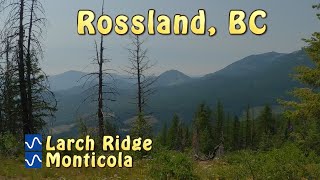
Larch Ridge is a good little cross country trail that provides a variety of different riding including some natural technical features such as rocks and roots (as should be expected in the nature) while still providing a variety of line options to cater to different skill levels. Perhaps best known as the trail that leads to Monticola or BS, however, Larch Ridge stands out on its own with stunning views and well built sustainable single track. Park at the Biathlon Parking area, and utilize the new trail developments to ride a full single-track loop. On the right day you may assume God himself built these trails, but he didn't. Dedicated volunteers and locally funded trail crews did. Please support the wonderful work done by these people by donating to the Kootenay Columbia Trails Society.

Local Trail Association

Recent Activity on Trail

Past Week
  • 9 rides
  • 7 miles average
6 Months
  • 37 rides
  • 9 miles avg distance
All
  • 576 rides
  • Last: Jun 27, 2026
c1c2c3c4
January
February
March
April
May
June
July
August
September
October
November
December
update trails status or condition

Larch Ridge Trail Reports

statusdatedescription
Jun 1, 2026 @ 5:19pm (America/Vancouver)
Jun 1, 2026
reporter Trees cleared.
May 31, 2026 @ 2:00pm (America/Vancouver)
May 31, 2026
Two trees down on downhill starting section
May 23, 2026 @ 10:20am (America/Vancouver)
May 23, 2026
reporter The KCTS trail crew have cleared the trees, but the tread is still torn up in places, and the trail is not recommended for riding at this time.
May 10, 2026 @ 8:23am (America/Vancouver)
May 10, 2026
Did a recon lap of Larch to BS, Monticola and COG. Significant blowdown on all. Volunteers will be working on clearing what we can over the next...
Oct 6, 2025 @ 5:38am (America/Vancouver)
Oct 6, 2025
reporter Cleared.
more »
Status:
on Jun 1, 2026
Ideal
Avg: 4.41 (23 votes)
Your vote: 0

view (3,066)
close
3D
Trail Conditions
  • Unknown
  • Snow Groomed
  • Snow Packed
  • Snow Covered
  • Snow Cover Partial
  • Freeze/thaw Cycle
  • Icy
  • Prevalent Mud
  • Wet
  • Variable
  • Ideal
  • Dry
  • Very Dry
Trail Flow (Ridden Direction)
Trailforks scans users ridelogs to determine the most popular direction each trail is ridden. A good flowing trail network will have most trails flowing in a single direction according to their intension.
The colour categories are based on what percentage of riders are riding a trail in its intended direction.
  • > 96%
  • > 90%
  • > 80%
  • > 70%
  • > 50%
  • < 50%
  • bi-directional trail
  • no data
Trail Last Ridden
Trailforks scans ridelogs to determine the last time a trail was ridden.
  • < 2 days
  • < 1 week
  • < 2 weeks
  • < 1 month
  • < 6 months
  • > 6 months
Trail Ridden Direction
The intended direction a trail should be ridden.
  • Downhill Only
  • Downhill Primary
  • Both Directions
  • Uphill Primary
  • Uphill Only
  • One Direction
Contribute Details
Colors indicate trail is missing specified detail.
  • Description
  • Photos
  • Description & Photos
  • Videos
Trail Popularity ?
Trailforks scans ridelogs to determine which trails are ridden the most in the last 9 months. Trails are compared with nearby trails in the same city region with a possible 25 colour shades. Think of this as a heatmap, more rides = more kinetic energy = warmer colors.
  • most popular
  • popular
  • less popular
  • not popular
ATV/ORV/OHV Filter
Max Vehicle Width
inches
US Cell Coverage
Legend
cell carrier legend

Radar Time
Activity Recordings
Trailforks uses anonymized public activity data. ?
Activity Recordings
Trailforks uses anonymized public activity data. ?
Personal Heatmap
Activity Types
all / none
Options
2
Date range month
Winter Trails
Warning A routing network for winter maps does not exist. Selecting trails using the winter trails layer has been disabled.
Missing Trails
Most Popular
Least Popular
Trails are colored based on popularity. The more popular a trail is, the more red. Less popular trails trend towards green.
Jump Magnitude Heatmap
Heatmap of where riders jump on trails. Zoom in to see individual jumps, click circles to view jump details.
BC Backroad Status

Service Road Atlas is a free to use, community-driven service for viewing and creating reports on the numerous back-country service roads around B.C. and Alberta.

map legend
Slope Aspect
Direction the slope faces
Flat N NE E SE S SW W NW
Trails Deemphasized
Trails are shown in grey.
disable
Only show trails with no bike usage.
Enable
Suggested Layers
Based on selected activity type

    Save the current map location and zoom level as your default home location whenever this page is loaded.

    Save
        Directions to larch-ridge trailhead (49.154720, -117.846260)

        Photos

        21 more »
        62 |
        Oct 8, 2023 @ 12:54pm
        Oct 8, 2023
        61 |
        Jul 24, 2021 @ 9:23pm
        Jul 24, 2021
        76 |
        Jul 24, 2021 @ 9:23pm
        Jul 24, 2021
        57 |
        Jul 24, 2021 @ 9:23pm
        Jul 24, 2021

        Videos

        1 more »
        youtuber Larch Ridge and Monticola
        11:52 | 151 | Aug 13, 2024 , Rossland

        Trail Lists

        Routes with this trail

        4.7 5 miles 1,054 ft 8 Loop
        begins the loop, starting from Highway 3B, 12 km north of Rossland. The first 2.4 km, is great x-country...
        5 miles 1,044 ft 3 Loop
        Perhaps Rossland's best introduction to the riding to expect here. Only a blue level of difficulty, but...
        36 miles 6,268 ft 58 Shuttled
        Combo of the best climbs and descents in the areas.

        5 Reviews & Comments


        We hope you've been enjoying Trailforks!

        Create a FREE account to view trail comments and much more.

        • By canadakaTF Pro Trailforks & contributors
        • #2184 - 9,768 views

        Frequently Asked Questions About Larch Ridge

        Where is Larch Ridge located?
        Larch Ridge is located in Neptune Creek, Rossland, British Columbia, Canada. It is part of the Neptune Creek trail network. The trailhead is located at coordinates 49.15472, -117.84626.
        How hard is Larch Ridge?
        Larch Ridge is rated as Blue difficulty. The physical rating is Moderate. The average grade is 1.3%. The climb difficulty is rated Blue.
        What is the elevation gain for Larch Ridge?
        Larch Ridge has 83 m of elevation gain. The trail has 48 m of elevation descent. The elevation ranges from 1,450 m to 1,515 m.
        Is Larch Ridge a point to point trail?
        Yes, Larch Ridge is a point to point trail. The direction is Downhill Only. The trail type is singletrack.

        Hit the Trail

        Open in App

        Get this trail on your phone instantly.
        open trail in app

        Download Trail

        Save to wishlist, Garmin & download.
        save the trail

        Find Related Routes

        Find routes and users activities that include this trail.
        find routes for this trail

        You must enter a description before submitting.