more stats
10.3 miles
Distance
501 ft
Climb
-544 ft
Descent
01:04:03
Avg time
-44 ft
Altitude change
377 ft
Altitude min
669 ft
Altitude max
421 ft
Altitude start
377 ft
Altitude end
-0.1%
Grade
-12.2%
Grade max
74.1%
Grade min
5 miles
Distance climb
4 miles
Distance down
1 mile
Distance flat
01:04:03
Avg time

Larkin Trail Details

  • Activities
    • Mountain Bike
    • Gravel Bike
    • Adaptive Bike
    • Winter Fat Bike
    • Horse
    • Hike
    • Trail Running
    • Snowshoe
    • Nordic Ski
  • Riding Area
    Southbury
    , Connecticut
  • Difficulty Rating
  • Local Popularity
    5 in Mountain Biking [+]
    • 5 in Trail Running
    • 5 in Hiking
    • 5 in Horseback
  • Hiking SAC Scale
    T1 Hiking
  • Trail Type
    Gravel Path
  • Bike Type
    XC, Fat, Adaptive MTB, Gravel
  • Direction
    Both Directions
  • Climb Difficulty
    Green
  • Physical Rating
    Easy
  • Trail Visibility
    Always easy to follow
  • Family Friendly
    Yes
  • Dogs Allowed
    Yes
  • Land Owner

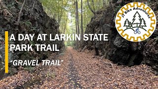
This is a rail trail with varying degrees of maintenance. The trail surface includes gravel, dirt, grass, and even a couple of areas where the path becomes part of a rocky or pebbly stream bed. Sometimes it is full rail trail width, but sometimes it shrinks down to singletrack. There will often be horse manure on the trail. During freeze/thaw cycles, there will be mud and ruts (a fatbike is the best bike during those periods). There are several road crossings where the path down to the road is narrow, steep and unimproved (especially at the western end). There are lots of scenic water views (streams, brooks, ponds, lakes).

Access Info

There are several areas to park along the way. The largest parking area is at the eastern end of the trail (Naugatuck). From the CT DEEP web site: "There are three parking areas in Southbury: 1. At the western terminus where the trail meets Kettletown Road, 2. Southeast of Smith Road where the trail crosses Route 67, 3. Where the trail intersects with Strongtown Road/Route 188. There are two parking areas in Oxford: 1. Where Prokop Road becomes Riggs Road, 2. At the northern end of Long Meadow Road at the Middlebury/Oxford town line. There is one parking area In Naugatuck: At the eastern terminus of the trail there is parking for 6 to 8 cars at Whittemore Glen State Park along Route 63.

Adaptive Bike Info
aMTB Black Rating: Advanced obstacles exist, some trail obstructions.

The biggest obstacles are some of the road crossings, where the path down to the road is steep, narrow, and rocky/rooty.

Local Trail Association
Traditionally Indigenous Territory

Recent Activity on Trail

Past Week
  • 0 rides
  •  
6 Months
  • 0 rides
  •  
All
  • 2 rides
  • Last: Jul 26, 2024
c1c2c3c4
January
February
March
April
May
June
July
August
September
October
November
December
update trails status or condition

Larkin Trail Trail Reports

statusdatedescription
Mar 26, 2026 @ 3:55pm (America/New_York)
Mar 26, 2026
Significant storm damage at site of former bridges that have washed out.
more »
Status:
on Mar 26, 2026
Ideal
Avg: 4.13 (1 votes)
Your vote: 0

view (49)
close
3D
Trail Conditions
  • Unknown
  • Snow Groomed
  • Snow Packed
  • Snow Covered
  • Snow Cover Partial
  • Freeze/thaw Cycle
  • Icy
  • Prevalent Mud
  • Wet
  • Variable
  • Ideal
  • Dry
  • Very Dry
Trail Flow (Ridden Direction)
Trailforks scans users ridelogs to determine the most popular direction each trail is ridden. A good flowing trail network will have most trails flowing in a single direction according to their intension.
The colour categories are based on what percentage of riders are riding a trail in its intended direction.
  • > 96%
  • > 90%
  • > 80%
  • > 70%
  • > 50%
  • < 50%
  • bi-directional trail
  • no data
Trail Last Ridden
Trailforks scans ridelogs to determine the last time a trail was ridden.
  • < 2 days
  • < 1 week
  • < 2 weeks
  • < 1 month
  • < 6 months
  • > 6 months
Trail Ridden Direction
The intended direction a trail should be ridden.
  • Downhill Only
  • Downhill Primary
  • Both Directions
  • Uphill Primary
  • Uphill Only
  • One Direction
Contribute Details
Colors indicate trail is missing specified detail.
  • Description
  • Photos
  • Description & Photos
  • Videos
Trail Popularity ?
Trailforks scans ridelogs to determine which trails are ridden the most in the last 9 months. Trails are compared with nearby trails in the same city region with a possible 25 colour shades. Think of this as a heatmap, more rides = more kinetic energy = warmer colors.
  • most popular
  • popular
  • less popular
  • not popular
ATV/ORV/OHV Filter
Max Vehicle Width
inches
US Cell Coverage
Legend
cell carrier legend

Radar Time
Activity Recordings
Trailforks uses anonymized public activity data. ?
Activity Recordings
Trailforks uses anonymized public activity data. ?
Personal Heatmap
Activity Types
all / none
Options
2
Date range month
Winter Trails
Warning A routing network for winter maps does not exist. Selecting trails using the winter trails layer has been disabled.
Missing Trails
Most Popular
Least Popular
Trails are colored based on popularity. The more popular a trail is, the more red. Less popular trails trend towards green.
Jump Magnitude Heatmap
Heatmap of where riders jump on trails. Zoom in to see individual jumps, click circles to view jump details.
BC Backroad Status

Service Road Atlas is a free to use, community-driven service for viewing and creating reports on the numerous back-country service roads around B.C. and Alberta.

map legend
Slope Aspect
Direction the slope faces
Flat N NE E SE S SW W NW
Trails Deemphasized
Trails are shown in grey.
disable
Only show trails with no bike usage.
Enable
Suggested Layers
Based on selected activity type

    Save the current map location and zoom level as your default home location whenever this page is loaded.

    Save
        Directions to larkin-trail trailhead (41.472260, -73.206560)

        Photos

        2 more »
        46 |
        Mar 26, 2026 @ 12:55pm
        Mar 26, 2026
        40 |
        May 31, 2023 @ 7:35am
        May 31, 2023
        53 |
        May 31, 2023 @ 7:35am
        May 31, 2023

        Videos

        1 more »
        Larkin State Park Trail | CT Gravel ride.
        2:16 | 112 | Oct 27, 2024 , Southbury

        4 Reviews & Comments


        We hope you've been enjoying Trailforks!

        Create a FREE account to view trail comments and much more.

        • By Wildbird99TF Pro CLIMB & contributors
        • #257318 - 2,244 views

        Frequently Asked Questions About Larkin Trail

        Where is Larkin Trail located?
        Larkin Trail is located in Southbury, Connecticut, United States. It is part of the Southbury trail network. The trailhead is located at coordinates 41.47226, -73.20656.
        What is the elevation gain for Larkin Trail?
        Larkin Trail has 501 ft of elevation gain. The trail has 544 ft of elevation descent. The elevation ranges from 377 ft to 669 ft.
        Is Larkin Trail a point to point trail?
        Larkin Trail is not a point to point trail. The direction is Both Directions. The trail type is gravel path.
        How long is Larkin Trail?
        Larkin Trail is 10.3 miles long. The trail type is gravel path.

        Hit the Trail

        Open in App

        Get this trail on your phone instantly.
        open trail in app

        Download Trail

        Save to wishlist, Garmin & download.
        save the trail

        Find Related Routes

        Find routes and users activities that include this trail.
        find routes for this trail

        You must enter a description before submitting.